Maps of Röcken

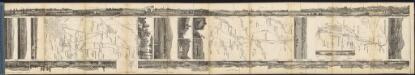
Instructio aciei Casareanorvm et Suecorvm prope Luzzenam
Lützen (Německo)
Meßtischblatt 4738 : Lützen, 1937
1 : 250000 Lützen. - Hrsg. 1905, bericht. 1930, einz. Nachtr. 1937. - 1:25000. - [Berlin]: Reichsamt für Landesaufnahme, 1937. - 1 Kt.
Meßtischblatt 2750 : Lützen, 1912
1 : 250000 Lützen. - Aufn. 1904, hrsg. 1905, einzelne Nachtr. 1912. - 1:25000. - [Berlin]: Reichsamt für Landesaufnahme, 1912. - 1 Kt.
Meßtischblatt 2750 : Lützen, 4738
1 : 250000 Lützen. - Aufn. 1904, hrsg. 1905, einz. Nachtr. 1906. - 1:25000. - [Berlin]: Reichsamt für Landesaufnahme, 1906. - 1 Kt.
Meßtischblatt 2750 : Lützen, 1905
1 : 250000 Lützen. - Aufn. 1904. - 1:25000. - [Berlin]: Reichsamt für Landesaufnahme, 1905. - 1 Kt.
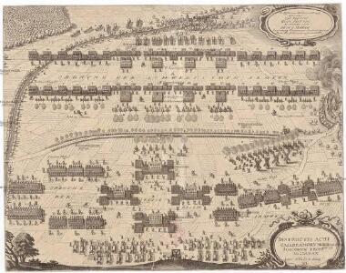
Plan der Schlacht von Gr. Goerschen den 2ten May 1813
1 : 25000 Brügner, Carl; Jäck; Prêtre, Jean Gabriel Pretre
Accurate Geographische Delineation des Hochs: Sachß. Amtes Weissenfels
1 : 80000 Mollova mapová sbírka Schenk, Pieter Xavery, Gerard Jozeph Schenk, Peter II
Praefecturae Leucopetranae delineatio geographica urbes, oppida, vicos, pagos, limitesque nova ratione complectens exhibita
1 : 80000 Mollova mapová sbírka Seutter, Matthäus Lotter, Tobias Conrad Seutter, Matthäus
Das Schlachtfeld von Leipzig oder die Gegend zwischen Wurzen und Merseburg
1 : 127600 Lipsko-oblast (Německo) Pluth, Caspar
Geometrischer General Ris des Stiffts Merseburg
1 : 80000 Mollova mapová sbírka Schenk, Pieter Schenk, Peter II
Accurate geographische Delineation des hochf. sachß. Amtes Weissenfels
1 : 80000 Sasko-Anhaltsko (Německo) Schenk, Pieter Peter Schenk
Accurate Geometrischer General Ris des Stiffts Merseburg
1 : 80000 Mollova mapová sbírka Schenk, Pieter Schenk, Peter II
Delineatio Geographica Ditionis Martisburgensis hodie regiis et electoralibus auspiciis florentis edita
1 : 80000 Mollova mapová sbírka Seutter, Matthäus Lotter, Tobias Conrad Seutter, Matthäus
Das Stifft Naumburg und Zeitz nebst einen grossen Theil derer angraentzenden Laender
1 : 130000 Mollova mapová sbírka Schreiber, Johann Georg Schreiber, Johann Georg
Chorographia Territorii Naumburgo-Citiensis
1 : 90000 Mollova mapová sbírka Schreiber, Johann Georg Homann, Johann Baptista - dědici

Episcopatus Numburgensis...

Accurate Geographische Delineation Des Stiffts Naumburg und Zeitz
1 : 120000 Mollova mapová sbírka Frankendaal, Nicolaas van Schenk, Peter II
Episcopatus Numburgensis Et Cizensis Delineatio geographica
1 : 120000 Mollova mapová sbírka Lotter, Tobias Conrad Seutter, Matthäus
Delineatio geographica Ditionis Martisburgensis...

114. Halle, uit: Topographische Uebersichtskarte des Deutschen Reiches / herausgegeben v. d. Kartogr. Abt. d. Königl. Preuß. Landesaufnahme
1 : 200000 titelvariant: Topogr. Übersichtskarte des Deutschen Reiches; Annotatie: Titel boven bladen ook: Topogr. Übersichtskarte des Deutschen Reiches; Annotatie geografische gegevens: Op elk blad twee maatstokken: 10 Kilometer = 5,5 cm; 1 geogr. Meile = 3,6 cm; Legenda onder op elk blad Königlich Preußische Landesaufnahme. Kartographische Abtheilung [S.l : Königlich Preußische Landesaufnahme, Kartographische Abtheilung]
Accurate geographische delineatio des Creis Ammtes Leipzig, nebst allen dar angrentzenden Aemtern und Gegenden
1 : 121000 Lipsko-oblast (Německo) Schenk, Pieter Lotter, Tobias Conrad P. Schenk
Charte der Sächs. Baiersch. Staats-Eisenbahn von Leipzig bis an die K. Baiersche Grenze
1 : 250000 Verlag v. J.G. Koch
Die Stiffter Merseburg und Naumburg mit dem Unter Stiffe Zeitz
1 : 380000 Mollova mapová sbírka Weigel, Johann Christoph Weigel, Christoph I.
MANSFELDIA | COMITATVS
Auctore Tilemanno Stella Sig. Apud Guiljelm. Blaeu.
Mansfeldia comitatvs / auctore Tilemanno Stella sig
1 : 170000 Annotatie: Origineel is Blad 99 in atlas factice; Annotatie geografische gegevens: Schaalvermelding op kaart: 2 Milliaria Germanica communia; Kaart toont het graafschap Mansfeld in het gebied tussen Aschersleben, Halle an der Saale, Wiehe Unstruttal en Stolberg Tilemann Stella 1525-1589 [Amsterdami : apud Guiljelm. Blaeu]
Mansfeldia Comitatus [Karte], in: Theatrum orbis terrarum, sive, Atlas novus, Bd. 1, S. 245.
1 Karte aus Atlas Blaeu, Joan Blaeu, Willem Janszoon
Mansfeldia Comitatus [Karte], in: Novus Atlas, das ist, Weltbeschreibung, Bd. 1, S. 162.
1 Karte aus Atlas Blaeu, Joan Blaeu, Willem Janszoon
Comitatus Mansfeldiae Descriptio. [Karte], in: Novus atlas absolutissimus, Bd. 2, S. 75.
1 Karte aus Atlas Janssonius Offizin