Maps of Olomouc
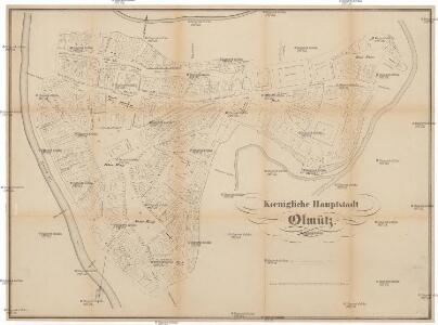
Koenigliche-Hauptstadt Olmütz
Olomouc (Česko) Rothaug, Johann Georg Netopil, Fr. F. Domek
Ollmütz - m2131-1-002 - Kaiserpflichtexemplar der Landkarten des stabilen Katasters
1 : 2880
Ollmütz - m2131-1-001 - Kaiserpflichtexemplar der Landkarten des stabilen Katasters
1 : 2880
Stadterweiterung Der Königl. Hauptstadt Olmütz
1 : 3000 Olomouc (Česko) Stadtbauamt Olmütz
Plan der königl. Hauptstadt Olmütz
1 : 4000 Olomouc (Česko) Ed. Hölzel
Olomouc

Entwurff der Stadt Olmütz
Olomouc (Česko) Salzer, Ignác Ign. Saltzer
Grundris. der Stadt Olmüz
Olomouc (Česko) Storch, Kajetán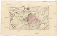
Accurater Grund Riß der Stadt und Vestung Ollmütz
Olomouc (Česko) in der Raspischen Buchhandlung
Accurater GrundRiss der Stadt und Vestung Ollmütz
Olomouc (Česko)
Plan. Von der Attaque der Festung Ollmütz
Morava, řeka Bonom, Franz Xa. de
Neumittergasse (Nowa Ulice) - m2024-1-003 - Kaiserpflichtexemplar der Landkarten des stabilen Katasters
1 : 2880
Neumittergasse (Nowa Ulice) - m2024-1-002 - Kaiserpflichtexemplar der Landkarten des stabilen Katasters
1 : 2880
Neumittergasse (Nowa Ulice) - m2024-1-001 - Kaiserpflichtexemplar der Landkarten des stabilen Katasters
1 : 2880
Neumittergasse (Nowa Ulice) - m2024-1-004 - Kaiserpflichtexemplar der Landkarten des stabilen Katasters
1 : 2880
Bez Titulu: Okolí Olomouce


III. vojenské mapování 4158/4
1 : 25000
III. vojenské mapování 4158/4
1 : 25000
Gradkartenblatt
1 : 25000 Morava (Česko) Duré, Friedrich
Übersichtskarte der Gegend um Olmütz
Olomouc-oblast (Česko) Domek
Olomouc
1 : 75000 Morava (Česko) Vojenský zeměpisný ústav
Prostějov a okolí
1 : 75000 Prostějov (Česko : oblast) Vojenský zeměpisný ústav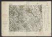
[Tschechoslowakie, Maßstab 1:75 000]. 4158, Olomouc : sonderausgabe : nur fur den dienstgebrauch
1 : 75000
Olmutz.; Spezialkarte der osterreichisch-ungarischen Monarchie.
from Spezialkarte der osterreichisch-ungarischen Monarchie. Austro-Hungarian Monarchy. Militärgeographisches Institut.,
Plan der königl. Hauptstadt Olmütz und Umgebung
1 : 2880 Olomouc-oblast (Česko) Schnizer, E. von Ed. Hölzel
Geologische Spezialkarte der... Österreichisch-Ungarischen Monarchie... Olmütz

Okolí olomucké
1 : 150000 Olomouc-oblast (Česko)
Geologische Spezialkarte der im Reichsrate vertretenen Königreiche und Länder der Österreichisch-Ungarischen Monarchie
1 : 75000 Olomouc (Česko : oblast) Tietze, Emil Ernst August Lipold, Markus Vincenc K. k. geologischen Reichsanstalt