Maps of Leicester

Insurance Plan of Leicester: sheet 36-1
1 : 960 This detailed 1892 plan of Leicester is one of a series of fifteen sheets in an atlas originally produced to aid insurance companies in assessing fire risks. The building footprints, their use (commercial, residential, educational, etc.), the number of floors and the height of the building, as well as construction materials (and thus risk of burning) and special fire hazards (chemicals, kilns, ovens) were documented in order to estimate premiums. Names of individual businesses, property lines, and addresses were also often recorded. Together these maps provide a rich historical shapshot of the commercial activity and urban landscape of towns and cities at the time. The British Library holds a comprehensive collection of fire insurance plans produced by the London-based firm Charles E. Goad Ltd. dating back to 1885. These plans were made for most important towns and cities of the British Isles at the scales of 1:480 (1 inch to 40 feet), as well as many foreign towns at 1:600 (1 inch to 50 feet). Chas E Goad Limited Chas E Goad Limited
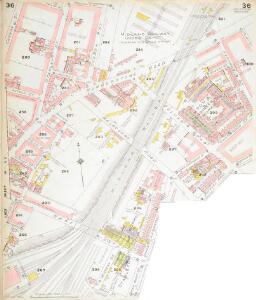
Insurance Plan of Leicester: sheet 36-4
1 : 960 This detailed 1892 plan of Leicester is one of a series of fifteen sheets in an atlas originally produced to aid insurance companies in assessing fire risks. The building footprints, their use (commercial, residential, educational, etc.), the number of floors and the height of the building, as well as construction materials (and thus risk of burning) and special fire hazards (chemicals, kilns, ovens) were documented in order to estimate premiums. Names of individual businesses, property lines, and addresses were also often recorded. Together these maps provide a rich historical shapshot of the commercial activity and urban landscape of towns and cities at the time. The British Library holds a comprehensive collection of fire insurance plans produced by the London-based firm Charles E. Goad Ltd. dating back to 1885. These plans were made for most important towns and cities of the British Isles at the scales of 1:480 (1 inch to 40 feet), as well as many foreign towns at 1:600 (1 inch to 50 feet). Chas E Goad Limited Chas E Goad Limited
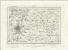
Leicestershire XXXI.11 (includes: Leicester) - 25 Inch Map
1 : 2500 Topographic maps Ordnance Survey Ordnance Survey
Leicestershire XXXI.11 (includes: Leicester) - 25 Inch Map
1 : 2500 Topographic maps Ordnance Survey Ordnance Survey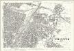
Leicestershire XXXI.11 (includes: Leicester) - 25 Inch Map
1 : 2500 Topographic maps Ordnance Survey Ordnance Survey
Insurance Plan of Leicester: sheet 32-1
1 : 960 This detailed 1892 plan of Leicester is one of a series of fifteen sheets in an atlas originally produced to aid insurance companies in assessing fire risks. The building footprints, their use (commercial, residential, educational, etc.), the number of floors and the height of the building, as well as construction materials (and thus risk of burning) and special fire hazards (chemicals, kilns, ovens) were documented in order to estimate premiums. Names of individual businesses, property lines, and addresses were also often recorded. Together these maps provide a rich historical shapshot of the commercial activity and urban landscape of towns and cities at the time. The British Library holds a comprehensive collection of fire insurance plans produced by the London-based firm Charles E. Goad Ltd. dating back to 1885. These plans were made for most important towns and cities of the British Isles at the scales of 1:480 (1 inch to 40 feet), as well as many foreign towns at 1:600 (1 inch to 50 feet). Chas E Goad Limited Chas E Goad Limited
Insurance Plan of Leicester: Key Plan 2
1 : 480 This "key plan" indicates coverage of the Goad 1892 series of fire insurance maps of Leicester that were originally produced to aid insurance companies in assessing fire risks. The building footprints, their use (commercial, residential, educational, etc.), the number of floors and the height of the building, as well as construction materials (and thus risk of burning) and special fire hazards (chemicals, kilns, ovens) were documented in order to estimate premiums. Names of individual businesses, property lines, and addresses were also often recorded. Together these maps provide a rich historical shapshot of the commercial activity and urban landscape of towns and cities at the time. The British Library holds a comprehensive collection of fire insurance plans produced by the London-based firm Charles E. Goad Ltd. dating back to 1885. These plans were made for most important towns and cities of the British Isles at the scales of 1:480 (1 inch to 40 feet), as well as many foreign towns at 1:600 (1 inch to 50 feet). Chas E Goad Limited Chas E Goad Limited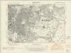
Leicestershire XXXI.SE - OS Six-Inch Map
1 : 10560 Topographic maps Ordnance Survey Ordnance Survey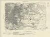
Leicestershire XXXI.SE - OS Six-Inch Map
1 : 10560 Topographic maps Ordnance Survey Ordnance Survey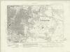
Leicestershire XXXI.SE - OS Six-Inch Map
1 : 10560 Topographic maps Ordnance Survey Ordnance Survey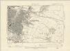
Leicestershire XXXI.SE - OS Six-Inch Map
1 : 10560 Topographic maps Ordnance Survey Ordnance Survey
Leicestershire XXXI.SE - OS Six-Inch Map
1 : 10560 Topographic maps Ordnance Survey Ordnance Survey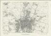
Leicestershire XXXI - OS Six-Inch Map
1 : 10560 Topographic maps Ordnance Survey Ordnance Survey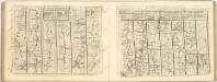
Leicester (Outline) - OS One-Inch Revised New Series
1 : 63360 Topographic maps Ordnance Survey Ordnance Survey
Leicester (Hills) - OS One-Inch Revised New Series
1 : 63360 Topographic maps Ordnance Survey Ordnance Survey
Burton Overy
1 : 31680 Light brushwork interlining ('hachuring')is used to represent the gently undulating clay vales and ridges that make up much of the area covered by this drawing. Enclosed farmland dominates the landscape. There are only small areas of woodland, indicated by dark green washes. Leicester is shown at middle left along the Fosse Way, the Roman road from Exeter to Lincoln, via Bath, Cirencester, and Leicester. Stevens, Henry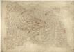
Leicester and Loughborough
1 : 31680 This plan covers part of Leicestershire, with the River Soar Valley forming the right-hand margin. In the middle of the sheet, the rocky peaks of Charnwood Forest are represented rising above the Leicestershire lowlands. Areas of ancient woodland and a significant proportion of wet woodland comprise the forest landscape. The underlying rocks are some of the oldest in England and Wales. The City of Leicester is depicted at middle-right along the banks of the Soar. Stevens, Henry
Derby and Leicester - OS One-Inch Map
1 : 63360 Topographic maps Ordnance Survey Ordnance Survey
Melton Mowbray - OS One-Inch Map
1 : 63360 Topographic maps Ordnance Survey Ordnance Survey
The counti of Warwick the shire towne and citie of Coventre described
1 : 1
Leicestrensis comitatvs
1 Karte : Kupferdruck ; 37 x 48 cm Blaeu Joan Blaeu
Leicestrensis Comitatus cum Rutlandiae vulgo Leicester & Rutland Shire
1 : 160000 Amstelodami : ex. Joannes Janssonius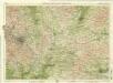
Birmingham, Leicester, Sheet 18 - Bartholomew's "Half Inch to the Mile Maps" of England & Wales
1 : 126720 Topographic maps Bartholomew, John George John Bartholomew & Co
An accurate map of the counties of Leicester and Rutland
1 Karte : Kupferdruck ; 52 x 68 cm Bowen; Tinney; Bowles; Sayer; Bowles; Bowles printed for I. Tinney at the Golden Lion and R. Sayer at the Golden Buck in Fleet street T. Bowles in St. Paul's Church yard and I. Bowles and son at the Black Horse in Cornhill
Leicestrensis comitatvs cum Rvtlandiæ vulgo Leicester [and] Rutland Shire
1 Karte : Kupferdruck ; 42 x 52 cm Valck; Schenk penes Gerardum Valk et Petrum Schenk
LEICESTRENSIS | COMITATVS. | LEICESTER SHIRE.
[Amsterdam : Joan Blaeu]
Leicestrensis Comitatus cum Rutlandiae. Vulgo Leicester & Rutland Shire. [Karte], in: Novus atlas absolutissimus, Bd. 7, S. 316.
1 Karte aus Atlas Janssonius Offizin
Leicestrensis Comitatus. Leicester Shire. [Karte], in: Le théâtre du monde, ou, Nouvel atlas contenant les chartes et descriptions de tous les païs de la terre, Bd. 4, S. 287.
1 Karte aus Atlas Blaeu, Willem Janszoon und Blaeu, Joan Blaeu, Willem Janszoon
An accurate map of Northampton Shire
1 Karte : Kupferdruck ; 68 x 51 cm Bowen; Hinton sold by I. Hinton at the Kings Arms in Newgate street
Comitatvs Northantonensis vernacule Northamton Shire
1 Karte : Kupferdruck ; 37 x 49 cm Valck; Schenk prostant in officina penes Gerardi Valk et Petri Schenk