Maps of Flemish Brabant

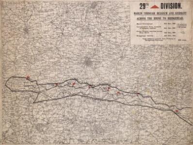
29th Division. March through Belgium and Germany across the Rhine to Bridghead. Sheet 1
1 : 250000 29th Division. March through Belgium and Germany across the Rhine to Bridghead. Sheet 1. Shows route of 29th Division who marched from Renaix in Belgium to Cologne in Germany to secure Rhine bridgehead immediately following the end of the First World War. War Office
[18], uit: Hydro-Oro und Chorographische General Karte des Koenigreichs der Niederlande und der angrenzenden Länder bis Paris : mit der Angabe der Kunst und Heer-Strassen und der Entfernung der Poststationen / ... zusammengetragen und reducirt von ... Wilhelm Müller
1 : 400000 titelvariant: Generalkarte des Koenigreichs Hannover; Annotatie: 1e supplement bij: Generalkarte des Koenigreichs Hannover (1818) Müller, Wilhelm (fl. 1818) [Hannover : Wilhelm Müller]
Le Brabant Espagnols et L'Eveché de Liege &c.
Mollova mapová sbírka Nolin, Jean-Baptiste Nolin, Jean Baptiste
Das Herzogthum Brabant
1 : 310000 Brabantsko
Le Duché De Brabant [...] [Karte], in: Atlas nouveau, contenant toutes les parties du monde [...], Bd. 2, S. 32.
1 Karte aus Atlas Sanson, Nicolas Jaillot, Alexis Hubert und Mortier, Pieter
Pars Meridionalis Brabantiae continens Dominium Mechliniense Ducatum Arschotanum [...] [Karte], in: Gerardi Mercatoris et I. Hondii Newer Atlas, oder, Grosses Weltbuch, Bd. 1, S. 387.
1 Karte aus Atlas Mercator, Gerhard und Hondius, Jodocus Jansson, Jan
Stoel des Oorlogs in Henegouwen, namen enz. Teatre de la Guerre en Hainaut et Namur &c.
1 : 250000 Mollova mapová sbírka Allard, Abraham Allart, Abraham

Le Pais d'Entre Sambre et Meuse
1 : 316000 Mollova mapová sbírka Fer, Nicolas de Inselin, Charles Danet, Guillaume
Brabantiae ducatus cum adjacentibus provinciis
1 : 310000 Brabantsko Seutter, Matthäus impensis Matthaei Seutteri
[Beschreibung deß Theils in Flandern, das dem Römischen Reich zugehöret.] [Karte], in: Gerardi Mercatoris et I. Hondii Newer Atlas, oder, Grosses Weltbuch, Bd. 1, S. 428.
1 Karte aus Atlas Mercator, Gerhard und Hondius, Jodocus Jansson, Jan
Brussel, uit: [Choro-mineralogische en algemeene hijdrographische kaart van een gedeelte der Zuidelijke provincien van het Koningrijk der Nederlanden] / ontworpen en volgens onder eigene directie verrigte opnemingen vervaardigd ... door den generaal-majoor en directeur der militaire verkenningen J.E. van Gorkum
1 : 200000 titelvariant: Choro-mineralogische en algemeene hydrographische kaart van een gedeelte der Zuidelijke provincien van het Koningrijk der Nederlanden; Algemeene kaart der fundamenteele of hoofddriehoeken getrokken over de Zuidelijke provincien van het Koningrijk der Nederlanden; Verdeeelings-blad der geologische en mineralogische kaart van een zuidelijk gedeelte der Nederlanden; Annotatie: Titel op het blad Bapaume: Algemeene kaart der fundamenteele of hoofddriehoeken getrokken over de Zuidelijke provincien van het Koningrijk der Nederlanden : tevens aanwijzende de verdeeling der bladen van de voor de militaire zowel als de civiele dienst ingerigte Choro-mineralogische en algemeene hijdrographische kaart van een gedeelte dezer genoemde provincien op de schaal van 1 el voor 200.000 ellen; Titel van bijlageblad: Verdeeelings-blad der geologische en mineralogische kaart van een zuidelijk gedeelte der Nederlanden; Van het blad Chimay zijn twee staten aanwezig; Annotatie geografische gegevens: 4 schaalstokken (op het blad Chimay) Jan Egbert van Gorkum 1781-1862 [S.l. : Directie der Militaire Verkenningen]
Brabant, Namur Partie Meridionale.
1 : 217500 Robert de Vaugondy, Gilles, 1688-1766
Brabant méridional, divisé en arrondissemens et cantons de justice de paix
1 : 190000 dressé et gravé par C. van Baarsel et Fils. A Amsterdam [etc.] : chez F.J. Weygand
Le Theatre de Bellone :
Mollova mapová sbírka Schenk, Pieter Braakman, Adriaan
[118][121] Pars meridionalis Brabantiae ..., uit: Atlas sive Descriptio terrarum orbis
Annotatie: Gedigitaliseerde versie. Amsterdam. Heiloo : Picturae (vervaardiger), 2015. tiff-bestand. Gedigitaliseerd: 07-01-2015; Origineel: Universiteitsbibliotheek Vrije Universiteit (XL.05127.-) ; Netherlands; Titelpagina ontbreekt Wit, Frederik de Amsterdam : Frederick de Wit
Pars Medionalis Brabantiae
1 : 220000 Mollova mapová sbírka Wit, Frederik de Covens, Johannes I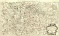
Le Duché de Brabant :
1 : 146000 Mollova mapová sbírka Jaillot, Alexis-Hubert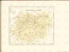

Bruxellensis tetrarchia
1 : 130000 Brusel-oblast (Belgie) Visscher, Nicolaus Schenk, Pieter apud Petr Schenk
Nieuwe Kaart van T' Graafschap Namen, met een Groot Gedeelte van T'Hertogdom Brabant
1 : 140000 Mollova mapová sbírka Visscher, Nicolaes Schenk, Peter II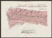
Secunda Pars Brabantiae cuius urbs primaria Bruxellae [Karte], in: Le théâtre du monde, ou, Nouvel atlas contenant les chartes et descriptions de tous les païs de la terre, Bd. 1, S. 346.
1 Karte aus Atlas Blaeu, Willem Janszoon und Blaeu, Joan Blaeu, Willem Janszoon
Tetrarchia Lovaniensis una cum Arschotano Ducatu
1 : 135000 quam emendatam [...] dedicat consecratque M. van Medtman Lovanii A Amsterdam : chez R. & I. Ottens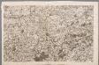
VIII, uit: Carte chorographique des Pays-Bas Autrichiens / ... par le Comte de Ferraris ; gravée par L.A. Dupuis
1 : 86400 Annotatie: Lit.: Les militaires et la cartographie des Pays-Bas méridionaux et de la Principauté de Liège à la fin du XVIIe et au XVIII siècle / Claire Lemoine-Isabeau. - Bruxelles, 1984, p. 206-212; La cartographie au XVIIIe siècle et l'oeuvre du Comte de Ferraris (1726-1814) : colloque international, Spa, 8-11 sept. 1976. - Bruxelles, 1978; Met opdracht aan keizer Joseph II (bl.XVI); Met plattegrond van Brussel (bl. XXI), overzichtskaart (bl. XXII) en bladwijzer (bl. XXIII); Ontbreekt: bl. I-III en XXI; Voor aanwezige bladen zie overzichtsblad Ferraris, Johann Joseph; Dupuis, L. A. [S.l. : s.n.]
Secunda Pars Brabantiae cuius urbs primaria Bruxellae [Karte], in: Novus atlas absolutissimus, Bd. 3, S. 47.
1 Karte aus Atlas Janssonius Offizin
Brüssel 82, uit: [W. Liebenow's Special-Karte von Mittel-Europa]
1 : 300000 titelvariant: W. Liebenow's Mittel-Europa; Annotatie: Titel boven de bladen: W. Liebenow's Mittel-Europa Johannes Wilhelm Liebenow 1822-1897 Hannover : Hermann Oppermann
Secunda Pars Brabantiae cuius urbs primaria Bruxellae [Karte], in: Novus Atlas, das ist, Weltbeschreibung, Bd. 1, S. 319.
1 Karte aus Atlas Blaeu, Joan Blaeu, Willem Janszoon
Carte particulière des mouvements faits, et des postes occupez par les armées des aliez commandées par le Roy de la Grande Bretagne et celles de France commandées par le Marechal de Villeroy pendant le siège de namur, 1695
1 : 160000 A Amsteldam : chez N. Visscher
Secunda Pars Brabantiae cuius urbs primaria Bruxellae [Karte], in: Theatrum orbis terrarum, sive, Atlas novus, Bd. 1, S. 340.
1 Karte aus Atlas Blaeu, Joan Blaeu, Willem Janszoon