Maps of Flemish Region

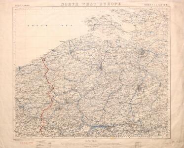
North West Europe: front line, June 27th, 1916, from Nieuport to Lens
1 : 250000 First World War map of North West Europe. Front line, June 27th, 1916, from Nieuport to Lens. War Office
[Belgie a Nizozemí]
Belgie Schraembl, Franz Anton F.A. Schraembl
Flandriae Comitatus Accuratissima Descriptio [Karte], in: Novus atlas absolutissimus, Bd. 3, S. 109.
1 Karte aus Atlas Janssonius Offizin
[105][108] Comitatus Flandriae tabula, uit: Atlas sive Descriptio terrarum orbis
Annotatie: Gedigitaliseerde versie. Amsterdam. Heiloo : Picturae (vervaardiger), 2015. tiff-bestand. Gedigitaliseerd: 07-01-2015; Origineel: Universiteitsbibliotheek Vrije Universiteit (XL.05127.-) ; Netherlands; Titelpagina ontbreekt Wit, Frederik de Amsterdam : Frederick de Wit
FLANDRIA | ET | ZEELANDIA | COMITATVS.
Apud Guiljelmum Blaeuw.
Comitatus Flandria
1 : 440000 Mollova mapová sbírka Visscher, Claes Jansz. Visscher, Claes Janszoon
FLANDRIA | ET | ZEELANDIA | COMITATVS.
Apud Guiljelmum Blaeuw.

Flandriae Comitatus accuratissima descriptio
1 : 320000 edita per Nicolaum Visscher. 't Amsteldam : by Nicolaes Visscher
Flandria. [Karte], in: Theatrum orbis terrarum, S. 48.
1 Karte aus Atlas Ortelius, Abraham
Flandriae Comitatus Descriptio. [Karte] [Walcheren. Borsele. Suitbeverlandt.] [Nebenkarte], in: Theatrum orbis terrarum, S. 186.
1 Karte aus Atlas Ortelius, Abraham Vrients, Jan Baptista
Caarte van T'Graafschap Vlaanderen :
1 : 250000 Mollova mapová sbírka Delisle, Guillaume
Flandriae Comitatus
1 : 166000 Mollova mapová sbírka Schenk, Pieter Schenk, Peter I
Flandria et Zeelandia Comitatvs
1 : 310000 Mollova mapová sbírka Blaeu, Willem Janszoon
Comitatus Flandriae tabula
1 : 284000 Flandry Wit, Frederick de Deur, Abraham F. de Wit
Comitatus Flandriae tabula
1 : 280000 Flandry Wit, Frederick de Deur, Abraham Frederico de Wit
Carte routiere du théatre de la guerre, contenant la Flandre, partie du Brabant et du Comte de Namur : dressée d'après la grande carte de Ferraris ...
1 : 250000 Annotatie: Het impressum vermeldt als jaar van uitgave: l'an 2eme de la République Française Paris : Basset
Flandriae comitatus
1 : 300000 Flandry Visscher, Nicolaus Nicolaes Visscher
FLANDRIAE COMITATUS Accuratissima Descriptio
1 : 300000 Flandry Visscher, Nicolaus by Nicolaes Visscher

Flandriae Comitatus
1 : 290000 Mollova mapová sbírka Visscher, Nicolaes Jansz. Visscher, Nicolaus II.
Flandriae comitauts in sua stoparchias optimé distinctus, uná cum vicinis et finitimis
1 : 330000 Flandry Schenk, Pieter Petr Schenck
Water supply Map of France and Belgium
1 : 250000 First World War map of water supply Map of France and Belgium. Showing relative abundance of water during dry summer months. War Office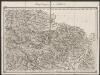
Flandria Comit: [Karte], in: Gerardi Mercatoris Atlas, sive, Cosmographicae meditationes de fabrica mundi et fabricati figura, S. 290.
1 Karte aus Atlas Mercator, Gerhard Montanus, Petrus
Comitatus Flandriae descriptio
1 : 250000 per observationes astronomicas Academiae Regiae Scientiarum quae est Parisiis per G. de L'Isle Augustae Vindelicorum : correcta nunc impensis Tobiae Conradi Lotter [...] edita
Flandria maximus et pulcherrimus Europae comitatus
1 : 310000 Flandry Seutter, Matthäus
Flandre.
1 : 258000 Robert de Vaugondy, Gilles, 1688-1766
Flandria
1 : 600000 Mollova mapová sbírka Mercator, Gerhard
Comitatus Flandriae in omnes ejusdem subjacentes ditio[n]es cum adjacentibus accuratißime divisus
1 : 300000 Flandry Homann, Johann Baptist sumtibus Ioh. Bapt. Homanni
Comitatus Flandriae in omnes ejusdem subjacentes ditio[n]es cum adjacentibus accuratißime divisus
1 : 300000 Flandry Homann, Johann Baptist sumtibus Ioh. Bapt. Homanni