Maps of Nord-Pas-de-Calais

Flandriae Comitatus Descriptio. [Karte] [Walcheren. Borsele. Suitbeverlandt.] [Nebenkarte], in: Theatrum orbis terrarum, S. 186.
1 Karte aus Atlas Ortelius, Abraham Vrients, Jan Baptista
Flandria. [Karte], in: Theatrum orbis terrarum, S. 48.
1 Karte aus Atlas Ortelius, Abraham

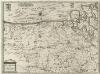
Flandriae Comitatus Accuratissima Descriptio [Karte], in: Novus atlas absolutissimus, Bd. 3, S. 109.
1 Karte aus Atlas Janssonius Offizin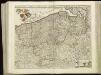
[105][108] Comitatus Flandriae tabula, uit: Atlas sive Descriptio terrarum orbis
Annotatie: Gedigitaliseerde versie. Amsterdam. Heiloo : Picturae (vervaardiger), 2015. tiff-bestand. Gedigitaliseerd: 07-01-2015; Origineel: Universiteitsbibliotheek Vrije Universiteit (XL.05127.-) ; Netherlands; Titelpagina ontbreekt Wit, Frederik de Amsterdam : Frederick de Wit
FLANDRIA | ET | ZEELANDIA | COMITATVS.
Apud Guiljelmum Blaeuw.
FLANDRIA | ET | ZEELANDIA | COMITATVS.
Apud Guiljelmum Blaeuw.
Comitatus Flandriae Nova Tabula. [Karte], in: Novus atlas absolutissimus, Bd. 3, S. 106.
1 Karte aus Atlas Janssonius Offizin
Flandria Et Zeelandia Comitatus. [Karte], in: Theatrum orbis terrarum, sive, Atlas novus, Bd. 1, S. 365.
1 Karte aus Atlas Blaeu, Joan Blaeu, Willem Janszoon
Flandria Et Zeelandia Comitatus. [Karte], in: Le théâtre du monde, ou, Nouvel atlas contenant les chartes et descriptions de tous les païs de la terre, Bd. 1, S. 383.
1 Karte aus Atlas Blaeu, Willem Janszoon und Blaeu, Joan Blaeu, Willem Janszoon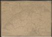
Comitatus Flandriae Nova Tabula. [Karte], in: Gerardi Mercatoris et I. Hondii Newer Atlas, oder, Grosses Weltbuch, Bd. 1, S. 416.
1 Karte aus Atlas Mercator, Gerhard und Hondius, Jodocus Jansson, Jan
Flandria Et Zeelandia Comitatus. [Karte], in: Novus Atlas, das ist, Weltbeschreibung, Bd. 1, S. 354.
1 Karte aus Atlas Blaeu, Joan Blaeu, Willem Janszoon
Flandriae Comitatus accuratissima descriptio
1 : 320000 edita per Nicolaum Visscher. 't Amsteldam : by Nicolaes Visscher
[Kaart], uit: Nord de la France Belgique (Ouest)
1 : 250000 titelvariant: Carte routière; Annotatie: Gevouwen, in pochette (19 x 13,5 cm); Titel op pochette: Carte routière; Met bladwijzer op pochette; Annotatie geografische gegevens: Met schaalstok; Legenda Paris : Taride / (Paris : Gaillac-Monrocq et Cie)
Flandria et Zeelandia Comitatvs
1 : 310000 Mollova mapová sbírka Blaeu, Willem Janszoon
Flandriae comitatus
1 : 300000 Flandry Visscher, Nicolaes Jansz. Gouwen, Giliam van der apud Petrum Schenk junior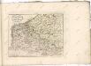

Flandriae comitauts in sua stoparchias optimé distinctus, uná cum vicinis et finitimis
1 : 330000 Flandry Schenk, Pieter Petr Schenck
Flandria maximus et pulcherrimus Europae comitatus
1 : 310000 Flandry Seutter, Matthäus
Flandriae Comitatus
1 : 290000 Mollova mapová sbírka Visscher, Nicolaes Jansz. Visscher, Nicolaus II.
Comitatus Flandriae tabula
1 : 284000 Flandry Wit, Frederick de Deur, Abraham F. de Wit
Comitatus Flandriae tabula
1 : 280000 Flandry Wit, Frederick de Deur, Abraham Frederico de Wit
Carte routiere du théatre de la guerre, contenant la Flandre, partie du Brabant et du Comte de Namur : dressée d'après la grande carte de Ferraris ...
1 : 250000 Annotatie: Het impressum vermeldt als jaar van uitgave: l'an 2eme de la République Française Paris : Basset
Le Comte de Flandre
1 : 300000 Mollova mapová sbírka Tralage, Jean-Nicolas de Nolin, Jean Baptiste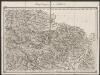
Flandria Comit: [Karte], in: Gerardi Mercatoris Atlas, sive, Cosmographicae meditationes de fabrica mundi et fabricati figura, S. 290.
1 Karte aus Atlas Mercator, Gerhard Montanus, Petrus
Le Comté De Flandre Devisé En Ses Chastellenies et Balliages, &c. Le Franc De Bruges et Le Pays De Waes Dedié Au Roy [Karte], in: Atlas nouveau, contenant toutes les parties du monde [...], Bd. 2, S. 50.
1 Karte aus Atlas Sanson, Nicolas Jaillot, Alexis Hubert und Mortier, Pieter
Les provinces des Pais Bas Autrichiens
Belgie Seutter, Matthäus par Matthieu Seutter
Flandria
1 : 600000 Mollova mapová sbírka Mercator, Gerhard
![Flandriae Comitatus Descriptio. [Karte] [Walcheren. Borsele. Suitbeverlandt.] [Nebenkarte], in: Theatrum orbis terrarum, S. 186.](https://images-2.georeferencer.com/images/iiif/647258787833/full/,300/0/native.jpg)

