Maps of Virginia
Lloyd's Military Campaign Charts: Virginia
Lloyd's Military Campaign Charts, showing the principal places of interest, compiled from official data by Gen. E.L. Viele and C. Haskins. Published under the auspices of the American Geographical and Statistical Society. Virginia.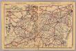
Del., Md., Va., W. Va.
1 : 1970000 Rand McNally and Company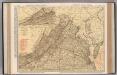
Virginia.
1 : 868000 Rand McNally and Company
Map of Virginia, Maryland and Delaware / I. Mutlow sc. 6 James St. Covt. Gardn.
I. Mutlow,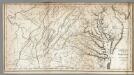
Virginia, Maryland and Delaware.
1 : 1584000 Morse, Jedidiah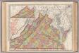
Virginia.
1 : 887000 Rand McNally and Company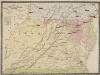
Pocket Map, showing the probable Theatre of the War. Compiled by G.A. Aschbach
Pocket Map, showing the probable Theatre of the War. Compiled by G.A. Aschbach. Published in Philadelphia, Pocket Map Showing the Probable Theatre of the War, complied by G.A. Aschbach, details the states of Virginia, Maryland and Pennsylvania. Published in 1860, before any major fighting had occurred, this map highlights areas that would see the bulk of fighting in the conflict. The map shows the balance on military power on either side by pointing out camps and forts. The Union held military bases are underlined in red, while Confederate holdings are in blue. The map also shows railway lines running across the states.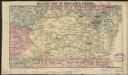
Military map of Maryland & Virginia
1 : 4400000 Charles
DOMINIA ANGLORUM in AMERICA SEPTENTRIONALI
1 : 1340000 Akádie Moll, Herman Homannianis Hered.
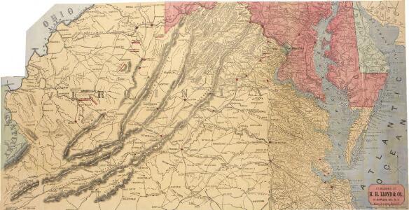
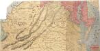
Lloyd's official map of the State of Virginia.
1 : 650000 Lloyd, J. T.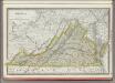
Virginia.
1 : 1480000 Rand McNally and Company
A map of the most inhabited part of Virginia: containing the whole province of Maryland with part of Pensilvania, New Jersey and North Carolina / drawn by Joshua Fry & Peter Jefferson in 1775.
from Charts and maps Joshua Fry & Peter Jefferson,
A map of Virginia: formed from actual surveys and the latest as well as the most accurate observations / by James Madison; drawn by Wm. Davis; with extensive additions and corrections to the year 1818.
from Charts and maps James Madison; William Davis,
A map of Virginia: formed from actual surveys and the latest as well as the most accurate observations / by James Madison; drawn by Wm. Davis; with extensive additions and corrections to the year 1818.
from Charts and maps James Madison; William Davis,
A map of Virginia: formed from actual surveys, and the latest as well as most accurate observations / by James Madison, D.D., president of Wm. & Mary College.; drawn by Wm. Davis; engraved by Fred. Bossler, Richmd.
from Charts and maps James Madison; William Davis; Fred. Bossler,
Virginia, Maryland & Delware.
1 : 3200000 Black, Adam & Charles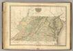
Virginia, Maryland, Delware.
1 : 1120000 Tanner, Henry S.
Virginia, Maryland, Washington D.C.
1 : 1518000 Finley, Anthony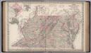
Delaware, Maryland, Virginia.
1 : 1267000 Colton, G.W.
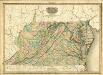
Virginia.
1 : 2500000 Tanner, Henry S.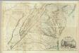
Composite: Virginia.
1 : 650000 Jefferys, Thomas
Virginia.
1 : 1650000 DeSilver, Robert
Virginia.
1 : 1700000 Cram, George Franklin; Davis, Ellis Arthur
Virginia. West Virginia.
1 : 2000000 Colton, G.W.
Del., Md., Va., W. Va.
1 : 1200000 Mitchell, Samuel Augustus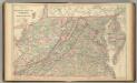
Del., Md., Va., W. Va.
1 : 1200000 Mitchell, Samuel Augustus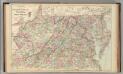
Del., Md., Va., W. Va.
1 : 1200000 Mitchell, Samuel Augustus Jr.
Map of Virginia, Maryland and Delaware.
1 : 633600 Burr, David H., 1803-1875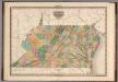
Virginia, Maryland and Delaware.
1 : 1200000 Tanner, Henry S.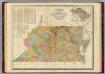
Map Of Virginia And Maryland.
1 : 1520000 Finley, Anthony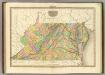
Virginia Maryland And Delaware.
1 : 1140480 Tanner, Henry S.
Virginia, Maryland and Delaware.
1 : 1200000 Tanner, Henry S.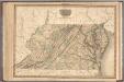
Virginia, Maryland and Delaware.
1 : 1200000 Tanner, Henry S.