Maps of St. Thomas the Apostle Rural

South Petherwin, Cornwall
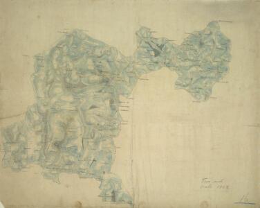
A triangulation diagram covers this whole drawing. This was used to plot the location of significant features around which other topographical details could be added., Trigonometric altitudes are recorded at the summit of inclines, while short disconnected lines are drawn in blue watercolour to represent relief - a technique known as 'hachuring'.,Several archaeological sites are recorded on this drawing, although this did not become obligatory until 1816.,In the lower section of the map to the left of Upton, a darkened triangular point is marked,'Cheese Wring'.,Below this is a stone circle named 'The Hurlers'.,Field boundaries are marked, with darker lines indicating the division between cultivated and uncultivated land.,A table of figures appears in pencil,to the lower right of the drawing.,Sealing wax is apparent on the reverse.,The paper is watermarked W. ELGAR 1796., Dawson, Robert
Tavistock (Hills) - OS One-Inch Revised New Series
1 : 63360 Topographic maps Ordnance Survey Ordnance Survey
Tavistock (Outline) - OS One-Inch Revised New Series
1 : 63360 Topographic maps Ordnance Survey Ordnance Survey
Callington, Cornwall
.Draughtsmen sometimes had to fit the area they were mapping on to an irregular shaped sheet of paper by changing its orientation. This is why this plan is not oriented northwards and Dunterton appears to the far right of Callington rather than above it. The Meridian of Kitt Hill is marked along the base of the drawing with Kit Hill Beacon as the centre point. Relief is indicated by grey brushwork and trigonometrical altitudes marked in red. The accuracy with which the Ordnance Survey drawings indicate relief set them apart from the earlier county maps and qualified them for military use. Holberton, R. R.
SX27 - OS 1:25,000 Provisional Series Map
1 : 25000 Topographic maps Ordnance Survey Ordnance Survey
SX37 - OS 1:25,000 Provisional Series Map
1 : 25000 Topographic maps Ordnance Survey Ordnance Survey
Launceston, Cornwall
This drawing of the area around Launceston in Cornwall displays several of the,characteristic techniques,of draughtsman, Robert Dawson (1771-1860).,He used dense colour washes and short, hatched lines pointing in the direction of slopes ('hachures') to,represent relief,,combining them,with numerical estimates of relative altitude.,Magnetic north is decoratively indicated just off the coast at Tintagell Castle, the legendary birthplace of King Arthur, to the central left of the picture.,Launceston Castle is,shown at the most easterly point of the smaller inland landmass.,Slate quarries are marked at Delaboule, in the centre of the left landmass, and Tresmarrow, in the centre of the right.,Pencil lines are clearly visible, recording the,angles between fixed points used for triangulation.,The paper carries an Edmeads,,amp; Pine watermark. Dawson, Robert
Cornwall XVII.SW - OS Six-Inch Map
1 : 10560 Topographic maps Ordnance Survey Ordnance Survey
Cornwall XVII.SW - OS Six-Inch Map
1 : 10560 Topographic maps Ordnance Survey Ordnance Survey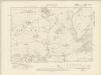
Cornwall XXIII.NW - OS Six-Inch Map
1 : 10560 Topographic maps Ordnance Survey Ordnance Survey
Cornwall XXIII.NW - OS Six-Inch Map
1 : 10560 Topographic maps Ordnance Survey Ordnance Survey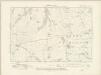
Cornwall XXIII.SW - OS Six-Inch Map
1 : 10560 Topographic maps Ordnance Survey Ordnance Survey
Cornwall XXIII.SW - OS Six-Inch Map
1 : 10560 Topographic maps Ordnance Survey Ordnance Survey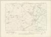
Cornwall XXIX.NW - OS Six-Inch Map
1 : 10560 Topographic maps Ordnance Survey Ordnance Survey
Cornwall XXIX.NW - OS Six-Inch Map
1 : 10560 Topographic maps Ordnance Survey Ordnance Survey
Cornwall XVI.SE - OS Six-Inch Map
1 : 10560 Topographic maps Ordnance Survey Ordnance Survey
Cornwall XVI.SE - OS Six-Inch Map
1 : 10560 Topographic maps Ordnance Survey Ordnance Survey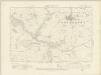
Cornwall XXIX.SW - OS Six-Inch Map
1 : 10560 Topographic maps Ordnance Survey Ordnance Survey
Cornwall XXIX.SW - OS Six-Inch Map
1 : 10560 Topographic maps Ordnance Survey Ordnance Survey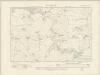
Cornwall XXII.NE - OS Six-Inch Map
1 : 10560 Topographic maps Ordnance Survey Ordnance Survey
Cornwall XXII.NE - OS Six-Inch Map
1 : 10560 Topographic maps Ordnance Survey Ordnance Survey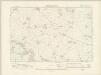
Cornwall XXII.SE - OS Six-Inch Map
1 : 10560 Topographic maps Ordnance Survey Ordnance Survey
Cornwall XXII.SE - OS Six-Inch Map
1 : 10560 Topographic maps Ordnance Survey Ordnance Survey
Cornwall XXVIII.NE - OS Six-Inch Map
1 : 10560 Topographic maps Ordnance Survey Ordnance Survey
Cornwall XXVIII.NE - OS Six-Inch Map
1 : 10560 Topographic maps Ordnance Survey Ordnance Survey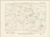
Cornwall XVI.SW - OS Six-Inch Map
1 : 10560 Topographic maps Ordnance Survey Ordnance Survey
Cornwall XVI.SW - OS Six-Inch Map
1 : 10560 Topographic maps Ordnance Survey Ordnance Survey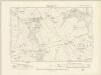
Cornwall XXVIII.SE - OS Six-Inch Map
1 : 10560 Topographic maps Ordnance Survey Ordnance Survey
Cornwall XXVIII.SE - OS Six-Inch Map
1 : 10560 Topographic maps Ordnance Survey Ordnance Survey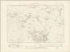
Cornwall XXII.NW - OS Six-Inch Map
1 : 10560 Topographic maps Ordnance Survey Ordnance Survey