Maps of North Atlantic Ocean

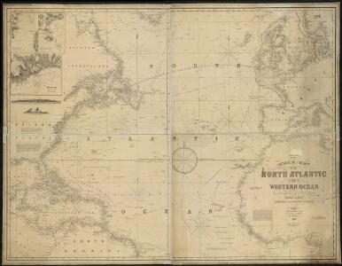
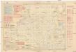
General chart, of the North Atlantic, or Western Ocean, from the equator to 62° north latitude, according to the latest, surveys and observations
1 : 9000000
North Atlantic Ocean.
1 : 8000000 Blunt, Edmund M. (Edmund March), 1770-1862
A chart of the Atlantic or Western Ocean / drawn from the latest surveys & astronomical observations by J. & A. Walker, London & Liverpool 1830.
from Atlantic Ocean J. & A. Walker,
Mar Del Nort. [Karte], in: Het vijfde Deel Des Grooten Atlas : Vervatende De Water-Weereld, S. 56.
1 Karte aus Atlas Jansson, Jan Jansson, Jan
Ueberfahrts-Karte.
1 : 30000000 Radefeld, Carl Christian Franz, 1788-1874
Mar del Nort / [Joannes Janssonius]
1 : 30000000 Annotatie: Origineel is Blad 3 in atlas factice Janssonius, Joannes (jr.) (1588-1664) [Amsterdam : Joannes Janssonius]
Mar Del Nort. [Karte], in: Novus atlas absolutissimus, Bd. 9, S. 58.
1 Karte aus Atlas Janssonius Offizin
Mar del nort
1 : 30000000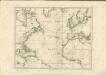
Pilot chart of the North Atlantic Ocean
1 : 14300000 Atlantský oceán (oblast) Maury, Matthew Fontaine Hydrographic Office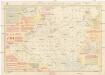
Pilot chart of the North Atlantic Ocean
1 : 14300000 Atlantský oceán (oblast) Maury, Matthew Fontaine Hydrographic Office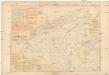
Pilot chart of the North Atlantic Ocean
1 : 14300000 Atlantský oceán (oblast) Maury, Matthew Fontaine Hydrographic Office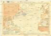
Pilot chart of the North Atlantic Ocean
1 : 11300000 Atlantský oceán (oblast) Hydrographic Office
Ueberfahrts-Karte
Grosser Hand-Atlas über alle Theile der Erde in 170 Karten Meyer, J. Verlag des Bibliographischen Instituts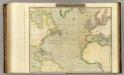
N. Atlantic Ocean.
1 : 22500000 Thomson, John
A new chart of the Atlantic or Western Ocean
1 : 9350000 Heather, W. (William) Heather, W. (William)
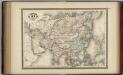
Asia.
1 : 31680000 Colton, G.W.
Carte de l'ocean Atlantique
1 Karte : Kupferdruck ; 47 x 61 cm Jefferys; Le Rouge chez Le Rouge rue des g.ds Augustins
Carte de l'océan Atlantique
1 Karte : Kupferdruck ; 48 x 61 cm Lattré chéz Lattré graveur du roy rue St. Jacques la porte cochère vis avis la rue de la Parcheminerie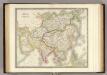
Asia.
1 : 27500000 Teesdale, Henry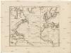
Karte des Atlantischen Oceans
1 : 7500000 Atlantský oceán-oblast Schraembl, Franz Anton F.A. Schraembl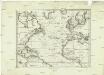
Karte des Atlantischen Oceans
1 : 22500000 Atlantský oceán-oblast Schraembl, Franz Anton F.A. Schraembl
Karte des Atlantischen Oceans
Atlantský oceán-oblast Schraembl, Franz Anton F.A. Schraembl
Karte des Atlantischen Oceans
1 Karte : Kupferdruck ; 48 x 60 cm Schrämbl zu finden in eigenem Verlage Schrämbl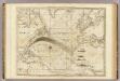
The Atlantic Ocean.
1 : 22500000 Pownall, Thomas
L'Asie, 1227 a 1840.
1 : 43000000 Houze, Antoine Philippe
Nord-Atlantischer Ocean
Hand-Atlas über alle Theile der Erde und über das Weltgebäude Stieler, Adolf Justus Perthes
Die Luftstromungen auf dem Nordatlantishcen Ocean.
1 : 29000000 Berghaus, Heinrich
Chart of the Atlantic Ocean.
1 : 43000000 Melish, John