Maps of Cumberland Plat.
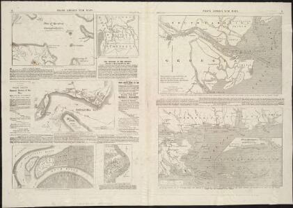
Frank Leslie's war maps
Leslie, Frank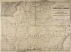
Railway Map of the Southern States, showing the Railway Lines, their Stations and intermediate distances between Louisville and the Gulf of Mexico and Southern Atlantic Coast, etc. Scale of miles, 20 to one inch.
Railway Map of the Southern States, showing the Railway Lines, their Stations and intermediate distances between Louisville and the Gulf of Mexico and Southern Atlantic Coast, etc.
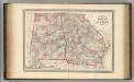
Georgia.
1 : 6336000 Scott, Joseph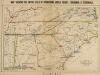
Map, shewing the Entire Field of Operations under Grant, Sherman & Thomas
Map, shewing the Entire Field of Operations under Grant, Sherman & Thomas. Published in London by Bacon & Co., this image of a Map Shewing the Entire Field of Operations, Under Grant, Sherman & Thomas details the Deep South Confederate States, principally of Tennessee, North Carolina, South Carolina, Georgia and Alabama, as well Virginia and the Union state of Kentucky. These areas witnessed the Union Army push in the last year and a half of the war, under the leadership of General Ulysses S. Grant. General George H. Thomas predominately fought in the western theatre of the conflict, while General William T. Sherman was responsible for the Army’s ultimately devastating march through the Southern states in 1864 and 1865. His marches through Georgia and the Carolinas, which crippled the home–front, remain a vital part of Civil War military history and Southern memory of the conflict. Bacon & Co.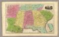
Southern States. (with) South Part of Florida.
1 : 3450000 Smiley, Thomas T.
County map of Georgia and Alabama.
from New general atlas.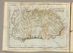
Georgia.
1 : 6000000 Carey, Mathew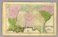
Southern States.
1 : 3500000 Olney, J. (Jesse), 1798-1872
Georgia.
1 : 2914560 Carey, Mathew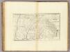
Georgia.
1 : 977920 Carey, Mathew
Georgia.
1 : 3000000 Lewis, Samuel
Georgia.
1 : 977920 Carey, Mathew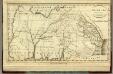
Georgia.
1 : 3000000 Winterbotham, W.
Campaigns in which the Army Of The Cumberland Took part during the War of the Rebellion.
1 : 1267200 Ruger, Edward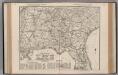
South Carolina. Florida. Georgia. Mississippi. Alabama. North Carolina. South Carolina.
1 : 1165000 Rand McNally and Company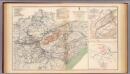
Army of the Cumberland campaigns.
1 : 2200000 United States. War Department
Georgia.
1 : 6500000 Henshaw, Frances A.
The State of Tennessee.
from Carey's general atlas, improved and enlarged : being a collection of maps of the world and quarters, their principal empires, kingdoms, &c.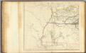
United States 2.
1 : 1750000 Arrowsmith, Aaron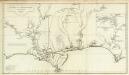
Carte de la Louisiane.
1 : 830000 Anville, Jean Baptiste Bourguignon d, 1697-1782
Virginiae partis australis, et Floridae partis orientalis, interjacentiumq[ue] regionum, nova descriptio.
from John H. Levine Collection Meurs, Jacob van; Montanus, Arnoldus,
Virginiae partis australis, et Floridae partis orientalis, interjacentiumq[ue] regionum nova descriptio.
from Parts J. and C. Blaeu: [Amsterdam]; Blaeu, Joan; Blaeu, Willem Janszoon,
Virginiae partis australis et Floridae partis orientalis interjacentimq[ue] regionum, nova descriptio.
from Charts and maps Ioannem Ianssonium?: [Amstelodami?]; Jansson, Jan,
Virginiae partis australis, et Floridae partis orientalis, interjacentiumq[ue] regionum nova descriptio.
from Parts J. and C. Blaeu: [Amsterdam]; Blaeu, Joan; Blaeu, Willem Janszoon,
Virginiae partis australis, et Floridae partis orientalis, interjacentiumq[ue] regionum nova descriptio.
from John H. Levine Collection J. and C. Blaeu: [Amsterdam]; Blaeu, Joan; Blaeu, Willem Janszoon,
Virginiae partis australis, et Floridae partis orientalis, interjacentiumq[ue] regionum nova descriptio.
from Charts and maps J. and C. Blaeu: [Amsterdam]; Blaeu, Joan; Blaeu, Willem Janszoon,
Virginiae partis australis, et Floridae partis orientalis, interjacentiumq[ue] regionum nova descriptio.
from Parts J. and C. Blaeu: [Amsterdam]; Blaeu, Joan; Blaeu, Willem Janszoon,
County map of Georgia, and Alabama
1 : 2500000 Mitchell, Samuel Augustus Jr.
The State of Georgia.
from Carey's general atlas, improved and enlarged : being a collection of maps of the world and quarters, their principal empires, kingdoms, &c.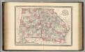
Georgia and Alabama.
1 : 1300000 Johnson, A.J.