Maps of Sabah
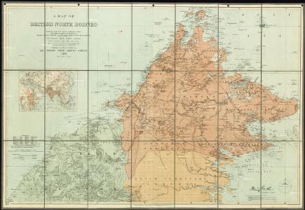
A map of British North Borneo.

Sabah

North Borneo / Topografische Dienst
Topografische Dienst Batavia Batavia : Reproductiebedrijf Topografische Dienst
North Borneo / U.S. Army Map Service
U.S. Army Map Service Washington D.C. Washington D.C. : U.S. Army Map Service
Blad XXIV Boven Serawai, blad b, uit: Residentie Wester-Afdeeling van Borneo : weg- en rivierkaart / Topographisch Bureau
1 : 50000 Annotatie: Voor aanwezige bladen zie overzichtsblad Topographisch Bureau, Batavia Batavia : Topographisch Bureau
Blad XXI Boven Embaloeh (2) en Blad XXII Boven Kapoewas, uit: Residentie Wester-Afdeeling van Borneo / Topographisch Bureau
1 : 200000 titelvariant: Residentie Westerafdeeling van Borneo; Annotatie: Titelvariant: Residentie Westerafdeeling van Borneo; Voor aanwezige bladen zie overzichtsblad; Annotatie geografische gegevens: Opname: 1886-1895 Topographisch Bureau, Batavia Batavia : Topographisch Bureau
Brunei / Survey of India
Survey of India [S.l.] : Survey of India
Blad VII Siding, blad b, uit: Residentie Wester-Afdeeling van Borneo : weg- en rivierkaart / Topographisch Bureau
1 : 50000 Annotatie: Voor aanwezige bladen zie overzichtsblad Topographisch Bureau, Batavia Batavia : Topographisch Bureau
Blad IV Padang Tikar, blad q, uit: Residentie Wester-Afdeeling van Borneo : weg- en rivierkaart / Topographisch Bureau
1 : 50000 Annotatie: Voor aanwezige bladen zie overzichtsblad Topographisch Bureau, Batavia Batavia : Topographisch Bureau
Miri / compilation: LHQ Cartographic Coy., Aust. Svy. Corps
Australian Survey Corps . LHQ Cartographic Company [S.l.] : LHQ Cartographic Coy
Kudat / compilation: LHQ Cartographic Coy., Aust. Svy. Corps
Australian Survey Corps . LHQ Cartographic Company [S.l.] : LHQ Cartographic Coy
Brunei Bay / compilation: LHQ Cartographic Coy., Aust. Svy. Corps
Australian Survey Corps . LHQ Cartographic Company [S.l.] : LHQ Cartographic Coy
Sindumin / compilation: LHQ Carthographic Coy., Aust. Svy. Corps
Australian Survey Corps . LHQ Cartographic Company [S.l.] : LHQ Carthographic Coy
Jesselton / compilation: LHQ Cartographic Coy., Aust. Svy. Corps
Australian Survey Corps . LHQ Cartographic Company [S.l.] : LHQ Cartographic Coy
Tawau / prepared under the direction of the Chief of Engineers by the Army Map Service, US Army
US Army Washington D.C. . Army Map Service Washington D.C. : Army Map Service, US Army
Tarakan / prepared under the direction of the Chief of Engineers by the Army Map Service, US Army
US Army Washington D.C. . Army Map Service Washington D.C. : Army Map Service, US Army
S. Lutong / compilation: LHQ Cartographic Coy., Aust. Svy. Corps
Australian Survey Corps . LHQ Cartographic Company [S.l.] : LHQ Cartographic Coy
Eiland Tarakan : Opgenomen door den Topografische Dienst (Luchtfotogrammetrische Sectie) in 1935
Topografische Dienst Batavia Batavia : Reproductiebedrijf Topografische Dienst
T[angoen]g Simaja / published by Survey Directorate H.Q. SEALF ; prepared under the direction of the Chief of Engineers
Survey Directorate H.Q. SEALF Washington D.C. : Army Map Service
Sipitang / compilation: LHQ Carthograpic Coy., Aust. Svy. Corps
Australian Survey Corps . LHQ Cartographic Company [S.l.] : LHQ Cartographic Coy
Labuan North / compilation: LHQ Cartographic Coy., Aust. Svy. Corps
Australian Survey Corps . LHQ Cartographic Company [S.l.] : LHQ Cartographic Coy
T[angoen]g Batoe / published by Survey Directorate H.Q. SEALF ; prepared under the direction of the Chief of Engineers
Survey Directorate H.Q. SEALF Washington D.C. : Army Map Service
Bt. Agok / compilation: LHQ Cartographic Coy., Aust. Svy. Corps
Australian Survey Corps . LHQ Cartographic Company [S.l.] : LHQ Cartographic Coy
Kota Belud / compilation: LHQ Cartographic Coy., Aust. Svy. Corps
Australian Survey Corps . LHQ Cartographic Company [S.l.] : LHQ Cartographic Coy
S. Mumiang / compilation: LHQ Cartographic Coy., Aust. Svy. Corps
Australian Survey Corps . LHQ Cartographic Company [S.l.] : LHQ Cartographic Coy
P. Kalampunian / compilation: LHQ Cartographic Coy., Aust. Svy. Corps
Australian Survey Corps . LHQ Cartographic Company [S.l.] : LHQ Cartographic Coy
Bt. Puan / compilation: LHQ Cartographic Coy., Aust. Svy. Corps
Australian Survey Corps . LHQ Cartographic Company [S.l.] : LHQ Cartographic Coy
Boeang / published by Survey Directorate H.Q. SEALF ; prepared under the direction of the Chief of Engineers
Survey Directorate H.Q. SEALF Washington D.C. : Army Map Service
Beluran / compilation: LHQ Cartographic Coy., Aust. Svy. Corps
Australian Survey Corps . LHQ Cartographic Company [S.l.] : LHQ Cartographic Coy