Maps of South America
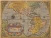
Americae Sive Novi Orbis, Nova Descriptio. [Karte], in: Theatrum orbis terrarum, S. 16.
1 Karte aus Atlas Ortelius, Abraham
America septentrionalis novissima
1 : 37000000 [Amstelodami] : P. Schenk ex.
Isles, caps et ports de mer de l'Amerique
1 Karte : Kupferdruck ; 30 x 33 cm, Blattgrösse 32 x 55 cm Clouet Mondhare
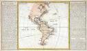
Composite: North and South America
1 : 1641836 Vandermaelen, Philippe, 1795-1869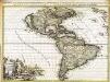
L'Amerique
1 Karte : Kupferdruck ; 44 x 58 cm Aa; Goere; Baptist chez I. Cóvens et C. Mortier
America
1 : 25370000 Amerika Kiepert, Heinrich Gräf, Carl Geographisches Institut
America 1841 mit Benutzung der neuesten Vermessungen
1 : 37600000 Amerika Arrowsmith, David K. Geographischen Anstalt des Bibliographischen Instituts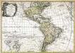
Carte d'Amerique
1 Karte : Kupferdruck ; 51 x 72 cm Nolin; Mondhare; Jean chez Monhare et Jean rue St. Jean de Beauvais
Západnj polokaule
Amerika Merklas, Václav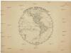
Západnj polokaule
Amerika Merklas, Václav
Západnj polokaule
Amerika Merklas, Václav
Západnj polokaule
Amerika Pluth Merklas, Václav
America
1 : 29000000 Amerika Weiland, Karl Ferdinand Geographisches Institut
America
1 : 28000000 Amerika Weiland, Karl Ferdinand Geographisches Institut
Western hemisphere
1 : 65000000 Amerika Walker, C. Society for the diffusion of useful knowledge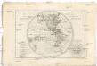
Mappe-monde sur le plan d'un méridien
Jižní Amerika André
AMERICÆ | nova Tabula
Auct: Guiljelmo Blaeuw [Amsterdam : Joan Blaeu]
Nouvelle carte de l'Amerique
1 Karte : Kupferdruck ; 42 x 52 cm Aa Pieter van der Aa
America
Hand-Atlas über alle Theile der Erde nach dem neuesten Zustande und über das Weltgebäude Stieler, Adolf bei Justus Perthes
Carte physique de la mer des Indes
1 Karte : Kupferdruck ; 27 x 34 cm, Blattgrösse 46 x 60 cm Buache; Desbruslins Philippe Buache
AMERICAE Aucta DELINEATIO
Amerika
Novae Insulae, XXVI. Nova Tabula. [Karte], in: Claud. Ptolemaeus. Geographia lat. cum mappis [...], S. 440.
1 Karte aus Atlas Münster, Sebastian [und Ptolemaeus, Claudius]
Amérique historique, physique et politique actuelle
Amerika Renouard, Paul Paul Renouard
Novissima et accuratissima totius Americæ descriptio
1 Karte : Kupferdruck ; 42 x 53 cm Visscher Nicolaes Visscher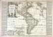
Amérique ou Nouveau Continent
1 Karte : Kupferdruck ; 46 x 52 cm, Gesamtgrösse 47 x 67 cm Nolin; Basset; Denis; Basset chès Basset rüe St. Jacques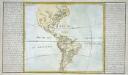
Lacs, fleuves, rivieres et principales montagnes de l'Amerique
1 Karte : Kupferdruck ; 31 x 36 cm, Bildgrösse 32 x 55 cm Clouet Mondhare
America.
1 : 67000000 Radefeld, Carl Christian Franz, 1788-1874
America siue India Nova
1 Karte : Kupferdruck ; Durchmesser 34 cm, Bildgrösse 37 x 46 cm Mercator; Mercator; Hondius Henricus Hondius
![Americae Sive Novi Orbis, Nova Descriptio. [Karte], in: Theatrum orbis terrarum, S. 16.](https://images-2.georeferencer.com/images/iiif/969682294145/full/,300/0/native.jpg)

