Maps of Jordan

Palaestinae Sive Totius Terrae Promissionis Nova Descriptio [Karte], in: Theatrum orbis terrarum, S. 425.
1 Karte aus Atlas Ortelius, Abraham
Palaestinae Sive Totius Terrae Promissionis Nova Descriptio [Karte], in: Theatrum orbis terrarum, S. 435.
1 Karte aus Atlas Ortelius, Abraham Vrients, Jan Baptista
Situs Terrae Promissionis. S.S. Bibliorum intelligentiam exacte aperiens [Karte], in: Novus atlas absolutissimus, Bd. 6, S. 108.
1 Karte aus Atlas Janssonius Offizin
Abrahami Patriarchae Peregrinatio, Et Vita. [Karte], in: Theatrum orbis terrarum, S. 444.
1 Karte aus Atlas Ortelius, Abraham Vrients, Jan Baptista
Situs Terrae Promissionis. S.S. Bibliorum intelligentiam exacte aperiens [Karte], in: Gerardi Mercatoris et I. Hondii Newer Atlas, oder, Grosses Weltbuch, Bd. 2, S. 347.
1 Karte aus Atlas Mercator, Gerhard und Hondius, Jodocus Jansson, Jan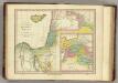
Places Recorded in the Five Books of Moses. (1826)
1 : 4600000 Tanner, Henry S.
Palestinae Sive Totius Terrae Promissionis Nova Descriptio [Karte], in: Theatrum orbis terrarum, S. 117.
1 Karte aus Atlas Ortelius, Abraham
Afbeelding van 't Koningryk Israëls, benevens de door 't zelve overheerde landen; gedurende de regering der koningen Saul, David, en Salomo
1 : 2300000 door W.A. Bachiene J. van Jagen mapp. sculpsit, et figur. apposit. sculpturam curavit ; J. Folkema f. Uitgegeven te Gorinchem : by Nicolaas Goetzee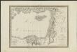
Carte physique & politique de la Syrie, pour servir à l'histoire des conquêtes du général Bonaparte en Orient
faite au Kaire en l'an 8, par Charles Paultre [...] dessiné par Lapie [...] ; gravé par Blondeau [...] ; l'écriture gravée par L. Aubert [...] A Paris [etc.] : chez Lapie [...] ; Picquet [...] [etc.]
Feuille 48 (F VII), uit: Carte géologique internationale de l'Europe : la carte, votée au congrès géologique international de Bologne en 1881, est exécutée conformément aux décisions d'une commission internationale, avec le concours des gouvernements, sous le dir. de M.M. Beyrich et Hauchecorne
Annotatie: Blad 48 gamme des couleurs; blad 49: bladwijzer en titelblad Heinrich Ernst Beyrich 1815-1896; Wi. Hauchecorne Berlin : Reimer / (Berlin: Institut lithographique)
Terra Sancta quae in Sacris Terra Promissionis olim Palestina [Karte], in: Novus Atlas, das ist, Weltbeschreibung, Bd. 2, S. 300.
1 Karte aus Atlas Blaeu, Joan Blaeu, Willem Janszoon
Syrien u. Aegypten
[Allgemeiner Atlas über alle Theile der Erde in 29 Blättern] Ziegler, Jakob Melchior Top. Anstalt v. J. Wurster u. Comp.
[Syrien und Aegypten]
Hypsometrischer Atlas Ziegler, Jakob Melchior Topogr. Anstalt v. J. Wurster u. Comp.
Terra Sancta quae in Sacris Terra Promissionis olim Palestina [Karte], in: Theatrum orbis terrarum, sive, Atlas novus, Bd. 2, S. 283.
1 Karte aus Atlas Blaeu, Joan Blaeu, Willem Janszoon
Iudaea seu Terra Sancta quae Hebraeorum sive Israelitarum in suas duodecim Tribus divisa; secretis ab invicem Regnis Iuda, et Israel [...] [Karte], in: Atlas nouveau, contenant toutes les parties du monde [...], Bd. 2, S. 212.
1 Karte aus Atlas Sanson, Nicolas Jaillot, Alexis Hubert und Mortier, Pieter
De beyde koningryken Juda en Israël, die na Salomo's dood zig van elkanderen afgescheurt hebben; benevens de overheerde landen aan elk dier beiden behorende
1 : 1400000 afgebeeldt door W.A. Bachiene J. van Jagen mapp. sculpsit, et figur. apposit. sculpturam curavit ; S. Fokke fec. Uitgegeven te Gorinchem : by Nicolaas Goetzee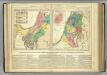
Canaan.
Lavoisne, M.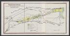
Terra Sancta quae in Sacris Terra Promissionis olim Palestina [Karte], in: Le théâtre du monde, ou, Nouvel atlas contenant les chartes et descriptions de tous les païs de la terre, Bd. 2, S. 276.
1 Karte aus Atlas Blaeu, Willem Janszoon und Blaeu, Joan Blaeu, Willem Janszoon
[Recto], uit: Situs terrae promissionis. S.S. Bibliorum intelligentiam exacte aperiens / per Chr. Adrichom ; sculpserunt Everardus Sim. Hamers-veldt et Salomon Rogeri
1 : 830000 Annotatie: Oorspr. verschenen in: L'Appendice de l'atlas de Gerard Mercator et Iudocus Hondius ... - A Amsterdam : chez Henry Hondius, 1633; Annotatie geografische gegevens: Zuidoost boven Adrichom, Christiaan van; Hamersveldt, Everard Symonsz. van; Rogiers, Salomon Amstelodami : sumptibus Henrici Hondii
Biblische-Karte
Jeruzalém Růžička, Jan Hichmann, A.
[Syrien, die Sinai-Halbinsel und Aegypten]
Geographischer Atlas über alle Theile der Erde Ziegler, Jakob Melchior Verlag von Dietrich Reimer
Palaestina seu Terra olim Sancta
Jordánské údolí (Jordánsko a Izrael) Harenberg, Johann Christoph ediderunt Heredes Homan[n]iani
PALAESTINA seu TERRA olim SANCTA
Jordánské údolí (Jordánsko a Izrael) Harenberg, Johann Christoph ediderunt Heredes Homan[n]iani

[Recto], uit: Terra Sancta qua in Sacris Terra Promissionis olim Palestina / [Willem Jansz. Blaeu]
1 : 1000000 Annotatie: Uit: Tweede deel van 't Toonneel des Aerdriicx, ofte Nieuwe atlas. - Amsterdami : apud Guiljelmum et Iohannem Blaeu, 1635 [of latere editie]; Annotatie geografische gegevens: Noordwest boven Blaeu, Willem Jansz. Amstelodami : ex officina Guiljelmi Blaeu
Historische Karte von Palestinae und Arabia Petraea mit einen grossen Theil von AEgypten
1 : 1100000 Egypt Mayr, Georg Wilkendorf, Fr. Mey & Widmayer
Palestine - Physical Geography.
Milner, Thomas
[Syrien, die Sinai-Halbinsel u. Aegypten]
Geographischer Atlas über alle Theile der Erde Ziegler, Jakob Melchior Verlag von Joh. Wurster um Comp.
Syrien, Sinai u. Aegypten.
1 : 1600000 Ziegler, J. M.
![Palaestinae Sive Totius Terrae Promissionis Nova Descriptio [Karte], in: Theatrum orbis terrarum, S. 425.](https://images-2.georeferencer.com/images/iiif/963566045898/full/,300/0/native.jpg)

