Maps of Jordan

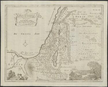
De beyde koningryken Juda en Israël, die na Salomo's dood zig van elkanderen afgescheurt hebben; benevens de overheerde landen aan elk dier beiden behorende
1 : 1400000 afgebeeldt door W.A. Bachiene J. van Jagen mapp. sculpsit, et figur. apposit. sculpturam curavit ; S. Fokke fec. Uitgegeven te Gorinchem : by Nicolaas Goetzee
Palestinae Sive Totius Terrae Promissionis Nova Descriptio [Karte], in: Theatrum orbis terrarum, S. 117.
1 Karte aus Atlas Ortelius, Abraham
Iudaea seu Terra Sancta quae Hebraeorum sive Israelitarum in suas duodecim Tribus divisa; secretis ab invicem Regnis Iuda, et Israel [...] [Karte], in: Atlas nouveau, contenant toutes les parties du monde [...], Bd. 2, S. 212.
1 Karte aus Atlas Sanson, Nicolas Jaillot, Alexis Hubert und Mortier, Pieter
La Palestine...

Situs Terrae Promissionis. S.S. Bibliorum intelligentiam exacte aperiens [Karte], in: Novus atlas absolutissimus, Bd. 6, S. 108.
1 Karte aus Atlas Janssonius Offizin
Terra Sancta quae in Sacris Terra Promissionis olim Palestina [Karte], in: Novus Atlas, das ist, Weltbeschreibung, Bd. 2, S. 300.
1 Karte aus Atlas Blaeu, Joan Blaeu, Willem Janszoon
Terra Sancta quae in Sacris Terra Promissionis olim Palestina [Karte], in: Theatrum orbis terrarum, sive, Atlas novus, Bd. 2, S. 283.
1 Karte aus Atlas Blaeu, Joan Blaeu, Willem Janszoon
Syrien und die angraenzenden Laender zur Zeit der Kreuzzuge.
1 : 3000000 Spruner von Merz, Karl
[Recto], uit: Situs terrae promissionis. S.S. Bibliorum intelligentiam exacte aperiens / per Chr. Adrichom ; sculpserunt Everardus Sim. Hamers-veldt et Salomon Rogeri
1 : 830000 Annotatie: Oorspr. verschenen in: L'Appendice de l'atlas de Gerard Mercator et Iudocus Hondius ... - A Amsterdam : chez Henry Hondius, 1633; Annotatie geografische gegevens: Zuidoost boven Adrichom, Christiaan van; Hamersveldt, Everard Symonsz. van; Rogiers, Salomon Amstelodami : sumptibus Henrici Hondii
Terra Sancta quae in Sacris Terra Promissionis olim Palestina [Karte], in: Le théâtre du monde, ou, Nouvel atlas contenant les chartes et descriptions de tous les païs de la terre, Bd. 2, S. 276.
1 Karte aus Atlas Blaeu, Willem Janszoon und Blaeu, Joan Blaeu, Willem Janszoon
[Syrien, die Sinai-Halbinsel und Aegypten]
Geographischer Atlas über alle Theile der Erde Ziegler, Jakob Melchior Verlag von Dietrich Reimer
Palaestina seu Terra olim Sancta
Jordánské údolí (Jordánsko a Izrael) Harenberg, Johann Christoph ediderunt Heredes Homan[n]iani
PALAESTINA seu TERRA olim SANCTA
Jordánské údolí (Jordánsko a Izrael) Harenberg, Johann Christoph ediderunt Heredes Homan[n]iani
Canaan.
Lavoisne, M.
[Syrien, die Sinai-Halbinsel u. Aegypten]
Geographischer Atlas über alle Theile der Erde Ziegler, Jakob Melchior Verlag von Joh. Wurster um Comp.
Syrien, Sinai u. Aegypten.
1 : 1600000 Ziegler, J. M.
Palestine - Physical Geography.
Milner, Thomas
TERRA SANCTA | quae in Sacris | Terra Promissionis olim | PALESTINA
Amstelodami | Ex officina Guiljelmi Blaeuw 1629
[Recto], uit: Terra Sancta qua in Sacris Terra Promissionis olim Palestina / [Willem Jansz. Blaeu]
1 : 1000000 Annotatie: Uit: Tweede deel van 't Toonneel des Aerdriicx, ofte Nieuwe atlas. - Amsterdami : apud Guiljelmum et Iohannem Blaeu, 1635 [of latere editie]; Annotatie geografische gegevens: Noordwest boven Blaeu, Willem Jansz. Amstelodami : ex officina Guiljelmi Blaeu
Syrie et Palestine. Asie 63.
1 : 1641836 Vandermaelen, Philippe, 1795-1869
Syrie et de la Palestine, 624 ans apres J.C.
1 : 3300000 Houze, Antoine Philippe
Biblische-Karte
Jeruzalém Růžička, Jan Hichmann, A.
Historische Karte von Palestinae und Arabia Petraea mit einen grossen Theil von AEgypten
1 : 1100000 Egypt Mayr, Georg Wilkendorf, Fr. Mey & Widmayer
Terre Sainte, pendant la premiere croisade de 1096 a 1144.
1 : 3300000 Houze, Antoine Philippe
Palestine.
1 : 1027000 Colton, G. Woolworth
Carte De La Mer Mediterranee. X.
Roux, Joseph
Terre Sainte en 1839.
1 : 3300000 Houze, Antoine Philippe
Terra Sancta XXIII. Nova Tabula. [Karte], in: Claud. Ptolemaeus. Geographia lat. cum mappis [...], S. 431.
1 Karte aus Atlas Münster, Sebastian [und Ptolemaeus, Claudius]