Maps of Cabo de Santo Agostinho

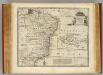
Capitaniarum De Phernambuca, Itamaraca, Paraiba, Et Rio Grande Nova Delineatio. [Karte], in: Novus atlas absolutissimus, Bd. 9, S. 82.
1 Karte aus Atlas Janssonius Offizin
PRÆFECTURÆ | DE PARAIBA, ET | RIO GRANDE
[Amsterdam : Joan Blaeu]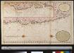
Een gedeelte van de cust van Brazilia tussen Punto de Lucena en Cabo St. Augustino int groot
Brazil Gerard van Keulen
PRÆFECTURÆ | PARANAMBUCÆ | PARS | BOREALIS, | una cum | PRÆFECTURA | de | ITÂMARACÂ.
[Amsterdam : Joan Blaeu]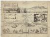
Olinda de Phernambuco
Olinda (Brazílie) Hollar, Václav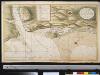
Het Zuijder Gadt bij t eijland Tamarica aen de kust van Brazilia op 7 graaden 42 minute(n) zuijder breeten
Brazil Gerard van Keulen
Eygentlicher abris und gelegenheit der vornemen hauptstadt des Königreichs Brasilien Phernambuco auch Olinda genandt inn America gelegen ...
1 : 1
Afteeckeninge vande Cap S. Augustyn
1 : 3500 Annotatie: Facs. van de uitg: Amsterdam : Iacob Kyns, [ca. 1635]. - Naar origineel Kaartenverzameling UBVU; Annotatie geografische gegevens: Legenda: Verclaringe der cyfer getallen, A-K, 1-6 [S.l. : s.n.]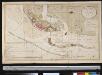
Caerte van de haven van Pharnambocque met de stad Mauritia geleegen aen de kust van Brazilia op 8 graaden 8 min. Zuijder Breeten
Brazil Gerard van Keulen
Afteeckeninge vande Cap S. Augustyn
1 : 3500 Annotatie geografische gegevens: Legenda: Verclaringe der cyfer getallen, A-K, 1-6 Amsterdam : Jacob Kyns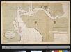
Ilho de Antonij Vaaz geleegen in Brazilia op 8 graden 8 min. Zuijder Breeten
Brazil Gerard van Keulen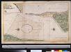
Rio Grande in Brazilia, op 5 graade 30 min Zuijder brete
Brazil Gerard van Keulen
Partie du Bresil. Amer. Merid. 19.
1 : 1641836 Vandermaelen, Philippe, 1795-1869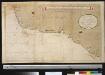
Een gedeelte van Brazilia tussen Bahia Baxa en Punto de Lucena
Brazil Gerard van Keulen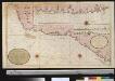
Een gedeelte van de kust van Brazilia tussen Bahia Baxa en Punto de Lucena
Brazil Gerard van Keulen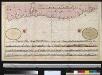
Een gedeelte van den kust van Brazilia tussen Cabo St. Augostino en Rio Coroipo int groodt
Brazil Gerard van Keulen
Maritima Brasiliae Universae
Blaeu, Joan [Blaeu]
Roteiro em Brazil no 1817-1821 do Dr. Pohl
1 : 16480000 Brazílie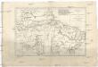
Brésil et pays des Amazones
1 : 10700000 Amazonka-oblast Bonne, Rigobert André
[Süd-Amerika in 6 Blättern, Blatt 2]
Adolf Stieler's Handatlas über alle Theile der Erde und über das Weltgebäude Stieler, Adolf Justus Perthes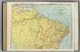
Brazil, Paraguay, and Uruguay (northern half).
1 : 5020000 Rand McNally and Company
Accuratissima Brasiliae tabula
1 : 4000000 Henricus Hondius excudit Amstelodami : Henricus Hondius
Nova et accurata Brasiliae totius tabula
1 : 6000000 Blaeu, Joan, 1596-1673 Nunc apud Petrum Schenk Junior
Accuratissima Brasiliae Tabula. [Karte] Baya de todos os Sanctos [Nebenkarte] Villa d'Olinda de Pernambuco [Nebenkarte], in: Gerardi Mercatoris et I. Hondii Newer Atlas, oder, Grosses Weltbuch, Bd. 2, S. 407.
1 Karte aus Atlas Mercator, Gerhard und Hondius, Jodocus Jansson, Jan
Novus Brasiliae Typus
Blaeu, Willem Janszoon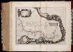
Maritima Brasiliæ universæ / [Joan Blaeu]
1 : 6375000 Annotatie: Kaart vertoont de plaatsen aan de westkust van Brazilië; Origineel is Blad 216 in atlas factice; Annotatie geografische gegevens: Schaalstokken op kaart: 60 Milliaria Germanica 15 uni gradui respondentia (=7,2 cm), en: 70 Milliaria Hispanica 17 1/2 gradui respondentia (=7,2 cm); West boven Joan Blaeu 1597/98-1673 [Amsterdam] : [Blaeu]
Nova et accurata Brasiliae totius tabula
1 : 6000000 Auctore Ioanne Blaeu I.F. [engraver: Johannes de Broen] [Amsterdam] : nunc apud Petrum Schenk Junior
Recens elaborata mappa geographica regni Brasiliae in America Meridionali maxime celebris
1 : 6000000
![Capitaniarum De Phernambuca, Itamaraca, Paraiba, Et Rio Grande Nova Delineatio. [Karte], in: Novus atlas absolutissimus, Bd. 9, S. 82.](https://images-2.georeferencer.com/images/iiif/154766137061/full/,300/0/native.jpg)

