Maps of Brazilian Highlands

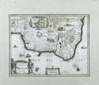
Novus Brasiliae Typus
Blaeu, Willem Janszoon
Brasilia [Karte], in: Le théâtre du monde, ou, Nouvel atlas contenant les chartes et descriptions de tous les païs de la terre, Bd. 2, S. 338.
1 Karte aus Atlas Blaeu, Willem Janszoon und Blaeu, Joan Blaeu, Willem Janszoon
Maritima Brasiliæ universæ / [Joan Blaeu]
1 : 6375000 Annotatie: Kaart vertoont de plaatsen aan de westkust van Brazilië; Origineel is Blad 216 in atlas factice; Annotatie geografische gegevens: Schaalstokken op kaart: 60 Milliaria Germanica 15 uni gradui respondentia (=7,2 cm), en: 70 Milliaria Hispanica 17 1/2 gradui respondentia (=7,2 cm); West boven Joan Blaeu 1597/98-1673 [Amsterdam] : [Blaeu]
Accuratissima Brasiliae Tabula. [Karte] Baya de todos os Sanctos [Nebenkarte] Villa d'Olinda de Pernambuco [Nebenkarte], in: Novus atlas absolutissimus, Bd. 6, S. 243.
1 Karte aus Atlas Janssonius Offizin
General chart of the coasts of Brasil, &c. from the River Para to Buenos-Ayres.
1 : 2500000 Purdy, John
[146][149] Littora Brasiliae ... Pascaert van Brasil, uit: Atlas sive Descriptio terrarum orbis
Annotatie: Gedigitaliseerde versie. Amsterdam. Heiloo : Picturae (vervaardiger), 2015. tiff-bestand. Gedigitaliseerd: 07-01-2015; Origineel: Universiteitsbibliotheek Vrije Universiteit (XL.05127.-) ; Netherlands; Titelpagina ontbreekt Wit, Frederik de Amsterdam : Frederick de Wit
Paskaart van Brasil : van Rio de los Amazones, tot Rio de la Plata
1 : 4500000 Annotatie: Uit: De zee-atlas, ofte water-weereld ... - Amsterdam : Pieter Goos, 1666 [Amsterdam : Pieter Goos]
Recens elaborata mappa geographica regni Brasiliae in America Meridionali
1 : 5800000 Brazílie Seutter, Matthäus per Matth. Seutterum
Brasilia [Karte], in: Theatrum orbis terrarum, sive, Atlas novus, Bd. 2, S. 351.
1 Karte aus Atlas Blaeu, Joan Blaeu, Willem Janszoon
Chart of the lighthouses of the Brazilian coast
1 : 8538000 Jaceguay, Arthur 1843-1914; Mission brésilienne d'expansion économique Paris : Mission brésilienne d'expansion économique
Littora Brasiliæ
1 Karte : Kupferdruck ; 47 x 56 cm Renard apud L. Renard
227-228. South America, East. The World Atlas.
1 : 7500000 USSR (Union of Soviet Socialist Republics).
Brazil.
1 : 9700000 Carey, Mathew
Map of Brazil.
1 : 9500000 Carey, Mathew
Composite: Brazil, Paraguay, and Uruguay.
1 : 5020000 Rand McNally and Company
Accuratissima Brasiliae Tabula. [Karte] Baya de todos os Sanctos [Nebenkarte] Villa d'Olinda de Pernambuco [Nebenkarte], in: Gerardi Mercatoris et I. Hondii Newer Atlas, oder, Grosses Weltbuch, Bd. 2, S. 407.
1 Karte aus Atlas Mercator, Gerhard und Hondius, Jodocus Jansson, Jan
Nova et accurata Brasiliae totius tabula
1 : 6000000 Blaeu, Joan, 1596-1673 Nunc apud Petrum Schenk Junior
Nova et accurata Brasiliae totius tabula
1 : 6000000 Auctore Ioanne Blaeu I.F. [engraver: Johannes de Broen] [Amsterdam] : nunc apud Petrum Schenk Junior

Recens elaborata mappa geographica regni Brasiliae in America Meridionali maxime celebris
1 : 6000000
Accuratissima Brasiliae tabula
1 : 4000000 Henricus Hondius excudit Amstelodami : Henricus Hondius
Brazil.
1 : 35000000 Fenner, Rest.
South America 4.
1 : 2800000 Arrowsmith, Aaron
Roteiro em Brazil no 1817-1821 do Dr. Pohl
1 : 16480000 Brazílie
Brasil.
1 : 9000000 Bowen, Emanuel
Maritima Brasiliae Universae
Blaeu, Joan [Blaeu]
A map of Brazil, now called New Portugal
1 : 9600000 Carey, Mathew, 1760-1839 M. Carey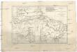
Brésil et pays des Amazones
1 : 10700000 Amazonka-oblast Bonne, Rigobert André
Eastern Brazil.
1 : 8400000 Sharpe, J.