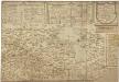
Maps of Västmanland

Dale Carliae et Westmanniae, Nova et Accurata descriptio. [Karte], in: Novus atlas absolutissimus, Bd. 1, S. 64.
1 Karte aus Atlas Janssonius Offizin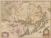
Uplandia. [Karte], in: Novus atlas absolutissimus, Bd. 1, S. 61.
1 Karte aus Atlas Janssonius Offizin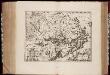
Vplandia
1 : 600000 Annotatie: Rechtsboven: XXIII; Origineel is Blad 142 in atlas factice; Annotatie geografische gegevens: Schaalstok op kaart: Milliaria Uplandica quorum 12 uni grad. altit. respondent [Oxford : apud Janssonio-Waesbergios et Mosem Pitt]
Finnskog
1 : 250000
Blad LVI
1 : 250000 Scott Ruud | O. Engh
Finnskog
1 : 250000
Geologisk karta öfver Fyris Åns Dalbäcken
1 : 100000 Annotatie geografische gegevens: 6 profielen. - 1:50.000. - hoogte 1:5.000 [S.l. : s.n.]
Karta öfver Sotholms Härad
1 : 50000 Stockholm (Švédsko : oblast) Rikets allmänna kartverk
Karta öfver Stockholm och dess omgifning
1 : 35000 Stockholm-oblast (Švédsko) Funck, Carl Oscar Carl Oscar Funck
Karta öfver Öknebo Härad
1 : 50000 Stockholm (Švédsko : oblast) Generalstabens litografiska anstalt
Karta öfver Trakten omkring Fahlun i Petridelauniskt afseende
1 : 25000 af N. G. Seftström Lith. af Spong & Cardon Stockholm : Theelz
Accurater Grundriß und Prospect DER KÖN. SCHWED. REICHS U. HAUPTSTADT STOCKHOLM
1 : 12000 Stockholm-oblast (Švédsko) Homann, Johann Baptist Ioh. Baptist Homann
Accurater Grundriß und Pospect der kön. schwed. Reichs u. Haupt Stadt Stockholm mit aller herumligenden Gegend, und annehmlicher Situation von innen u. aussen
Stockholm-oblast (Švédsko) Herzberg Homann, Johann Baptist Ioh. Baptist Homann
Environs of Copenhagen, Stockholm, Christiana, the Faroe Islands. Denmark and Schleswig-Holstein.
W. & A.K. Johnston Limited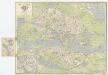
[Kaart], uit: Stockholm
1 : 12000 Annotatie: Met straatnamenregister; Annotatie geografische gegevens: Inzet: Staden : Mellan Broarna. - Schaal 1:6.000 Stockholm : Generalstabens Lithogr. Anstalts Förlag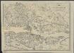
Stockholm
1 : 25000 gr. af C.G. Lundgren [S.l.] : [s.n.]
Plan von Stockholm
Grosser Hand-Atlas über alle Theile der Erde in 170 Karten Meyer, J. Verlag des Bibliographischen Instituts
Stockholm

PLAN von STOCKHOLM
1 : 30000 Stockholm (Švédsko)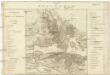
Plan von Stockholm
1 : 3000 Stockholm (Švédsko)
Plan-Karta öfver Stockholm
1 : 16000 [S.l.] : [s.n.]
Plan von Stockholm

Stockholm

Karta öfver Swearike och norra delen af Swerige
1 : 720000 författad af C.P. Hällström S. Anderson sc. [Stockholm] : Geografiska Inrättningen
SUEONIA | Proprie sic dicta
Auctore Andrea Buræo. [Amsterdam : Joan Blaeu]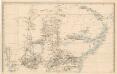
Trigonometrisk grunnlag, vedlegg 64b: Ort-Bestämmelsen i Södra Delen af Swerige
1 : 500000
Norgesavdelingen 38c sør: Græntse-Carte imellom Norge og Swerrige
1 : 800000 Jens Christian Spidberg
Ducatus Uplanida. [Karte], in: Theatrum orbis terrarum, sive, Atlas novus, Bd. 1, S. 61.
1 Karte aus Atlas Blaeu, Joan Blaeu, Willem Janszoon
![Dale Carliae et Westmanniae, Nova et Accurata descriptio. [Karte], in: Novus atlas absolutissimus, Bd. 1, S. 64.](https://images-2.georeferencer.com/images/iiif/919402266093/full/,300/0/native.jpg)

