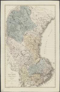
Maps of Svealand

Karta öfver Swearike och norra delen af Swerige
1 : 720000 författad af C.P. Hällström S. Anderson sc. [Stockholm] : Geografiska Inrättningen
SUEONIA | Proprie sic dicta
Auctore Andrea Buræo. [Amsterdam : Joan Blaeu]
Nordlandiae et quibies Gestricia et Helsingicae regiones
1 : 1285000 auctore Andrea Buraeo Sueco [Amsterdam] : J. Blaeu
NORDLANDIÆ | et quibies | GESTRICIA | et | HELSINGICÆ | REGIONES
Auct. Andrea Buræo Sueco. [Amsterdam : Joan Blaeu]
Dale Carliae et Westmanniae, Nova et Accurata descriptio. [Karte], in: Novus atlas absolutissimus, Bd. 1, S. 64.
1 Karte aus Atlas Janssonius Offizin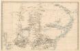
Trigonometrisk grunnlag, vedlegg 64b: Ort-Bestämmelsen i Södra Delen af Swerige
1 : 500000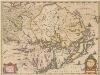
Uplandia. [Karte], in: Novus atlas absolutissimus, Bd. 1, S. 61.
1 Karte aus Atlas Janssonius Offizin
Vplandia
1 : 600000 Annotatie: Rechtsboven: XXIII; Origineel is Blad 142 in atlas factice; Annotatie geografische gegevens: Schaalstok op kaart: Milliaria Uplandica quorum 12 uni grad. altit. respondent [Oxford : apud Janssonio-Waesbergios et Mosem Pitt]
Norge 55-3: Accurat landcaart over Norges Rige anden Part
1 : 300000 G. Bordin
Norge 55-2: Accurat landcaart over Norges Rige anden Part
1 : 300000 G. Bordin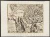
Ducatus Uplanida. [Karte], in: Theatrum orbis terrarum, sive, Atlas novus, Bd. 1, S. 61.
1 Karte aus Atlas Blaeu, Joan Blaeu, Willem Janszoon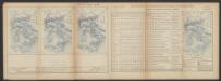
Ducatus Uplandia. [Karte], in: Le théâtre du monde, ou, Nouvel atlas contenant les chartes et descriptions de tous les païs de la terre, Bd. 1, S. 61.
1 Karte aus Atlas Blaeu, Willem Janszoon und Blaeu, Joan Blaeu, Willem Janszoon

Ducatus Uplandia. [Karte], in: Novus Atlas, das ist, Weltbeschreibung, Bd. 1, S. 49.
1 Karte aus Atlas Blaeu, Joan Blaeu, Willem Janszoon
DVCATVS | VPLANDIA.
Joh. et Cornelius Blaeu exc.
Blad LVI
1 : 250000 Scott Ruud | O. Engh
Vonsjøen
1 : 250000
Finnskog
1 : 250000
Ljørdalen
1 : 250000
Spesielle kart 41: Oversigtskroki over projekterede Banelinier Flisen-Halsjøen-Støa-Orsa
1 : 200000
Norge 55-7: Accurat landcaart over Norges Rige anden Part
1 : 300000 G. Bordin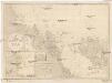
Ostsee
1 : 200000 Alandské ostrovy (Finsko : souostroví) Reichs-Marine-Amt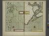
The channell of ABBO or UTTOY; A chart of STOCKHOLM Leith
from The sea-atlas : containing an hydrographical description of most of the sea-coasts of the known parts of the world.
XV
1 : 400000 R. Haavin
XV
1 : 400000 R. Haavin
XII
1 : 400000 N. Franck
XII
1 : 400000 N. Franck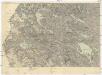
Östersund - Storlien
1 : 200000 Östersund (Švédsko) Generalstabens Litografiska Anstalt
Finnskog
1 : 250000