Maps of Belarus

Magni Ducatus Lithuaniae, Caeterarumque Regionum Illi Adiacentium Exacta Descriptio [...] [Karte], in: Novus Atlas, das ist, Weltbeschreibung, Bd. 1, S. 68.
1 Karte aus Atlas Blaeu, Joan Blaeu, Willem Janszoon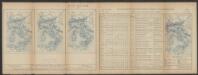
Magni Ducatus Lithuaniae, Caeterarumque Regionum Illi Adiacentium Exacta Descriptio [Karte], in: Le théâtre du monde, ou, Nouvel atlas contenant les chartes et descriptions de tous les païs de la terre, Bd. 1, S. 82.
1 Karte aus Atlas Blaeu, Willem Janszoon und Blaeu, Joan Blaeu, Willem Janszoon
Magni Ducatus Lithuaniae, caeterarumque Regionum Illi Adiacentium Exacta Descriptio [Karte], in: Theatrum orbis terrarum, sive, Atlas novus, Bd. 1, S. 84.
1 Karte aus Atlas Blaeu, Joan Blaeu, Willem Janszoon
Polens Umwandelungen von 1772-1809
1 : 2100000 Polsko zu finden in der Dykischen Buchhandlung
Paasche's Frontenkarte, Nr.6. Der Krieg gegen Russland

Polens Umwandelungen von 1772-1809
1 : 2100000 Bělorusko in der Dykischen Buchhandlung
Karta voennych dějstvīj 1768 - 1771 i 1794 g.g.
Polen Krieg
Het Koningkryk Polen, volgens de nieuwste waarneminge opgesteld
1 : 16000000 te Amsterdam : bij S. v. Esveldt

Charte von Polen
1 : 2300000 Bělorusko Kipferling, Karl Joseph Artaria
Historisch- statistisch- geographische Darstellung Koenigreichs Polen, 1770, 1773, 1793, 1795, 1807, 1815
Bělorusko Schlicht, Rudolph Rudolph Schlicht
Poland: Natural increase
1 : 3000000 Series of maps on various aspects of Poland. Natural increase. Annual increase of population. War Office
(La Pologne)
1 : 13000000 Bruyset, Jean-Marie; Schneider, J. H.
Estats de la couronne de Pologne
1 : 2800000 Evropa východní Jaillot, Alexis-Hubert H. Jaillot
ESTATS DE LA COURONNE DE POLOGNE
1 : 2800000 Evropa východní Jaillot, Alexis-Hubert H. Jaillot
Nyugat – Oroszország

Pohlen und Lithauen
1 : 2775000 Bělorusko Engelman, J. W.
Westliches Russland
1 : 2000000 Evropa východní Handtke, Friedrich Carl Flemming
Poland, Lithuania.
1 : 2600000 Cary, John, ca. 1754-1835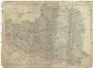
Das Königreich Polen nebst den angränzenden Ländern
1 : 1910000 Polsko Sotzmann, Daniel Friedrich im Verlag der Schneider u. Weigelschen Kunst- und Buchhandlung
MAGNI DVCATVS | LITHVANIÆ | et Regionum Adiacentium
exacta Descriptio | Ill.mi ac Excell.mi Principis et Dni. D. Nicolai Christophori Radziwil... opera, cura et impensis olim facta, ac nunc denuo hac forma edita a I. Blaeu. Ioannes Blaeu | Excudebat.
Poland, previous to 1772.
1 : 10000000 Fenner, Rest.
Poland.
1 : 5068800 Lucas, Fielding Jr.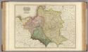
Poland.
1 : 2460000 Pinkerton, John, 1758-1826
Carte generale & itineraire de Pologne
1 : 5000000 Bělorusko Dorn, Sebastian Michel Gröll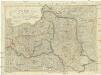
Polen unter Oestereich, Russland und Preussen getheilt
1 : 2100000 Evropa střední a východní Mollo, Tranquillo T. Mollo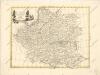
La polonia divisa ne ́suoi Palatinati

Carte Generale & Itineraire de Pologne
1 : 5000000 Mollova mapová sbírka Dorn, Sebastian Gröll, Michael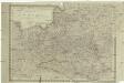
Königreich Pohlen
1 : 2055000 Bělorusko Schönberg, Johann Müller, And. Johann Schönberg
![Magni Ducatus Lithuaniae, Caeterarumque Regionum Illi Adiacentium Exacta Descriptio [...] [Karte], in: Novus Atlas, das ist, Weltbeschreibung, Bd. 1, S. 68.](https://images-2.georeferencer.com/images/iiif/379963633554/full/,300/0/native.jpg)

