Maps of Highland

Scotia Regnum [Karte] Orcades Insulae. [Nebenkarte], in: Le théâtre du monde, ou, Nouvel atlas contenant les chartes et descriptions de tous les païs de la terre, Bd. 3, S. 316.
1 Karte aus Atlas Blaeu, Willem Janszoon und Blaeu, Joan Blaeu, Willem Janszoon

Scotia Regnum [Karte] Orcades Insulae. [Nebenkarte], in: Novus Atlas, das ist, Weltbeschreibung, Bd. 3, S. 378.
1 Karte aus Atlas Blaeu, Joan Blaeu, Willem Janszoon
Scotia Regnum [Karte] Orcades Insulae [Nebenkarte], in: Gerardi Mercatoris et I. Hondii Newer Atlas, oder, Grosses Weltbuch, Bd. 1, S. 66.
1 Karte aus Atlas Mercator, Gerhard und Hondius, Jodocus Jansson, Jan
Scotia Regnum [Karte] Orcades Insulae. [Nebenkarte], in: Theatrum orbis terrarum, sive, Atlas novus, Bd. 4, S. 542.
1 Karte aus Atlas Blaeu, Joan Blaeu, Willem Janszoon
Scotia Regnum [Karte] Orcades Insulae. [Nebenkarte], in: Novus atlas absolutissimus, Bd. 8, S. 124.
1 Karte aus Atlas Janssonius Offizin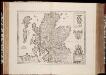
Scotia Regnum / [Joannes Janssonius]
1 : 1300000 Annotatie: Oorspr. verschenen in: Gerardi Mercatoris et I. Hondii appendix atlas ... - Amsterdam : bey Johan Jansson, 1636; Origineel is Blad 31 in atlas factice Janssonius, Joannes (jr.) (1588-1664) Amstelodami : apud Ioannem Ianssonium

Scotland or N. Britain.
1 : 1500000 Bowen, Emanuel
Nieuwe kaart van 't noorder gedeelte van Grootbritannie behelzelde het Koningryk Schotland
1 : 1750000 Annotatie: Uit: Nieuwe en beknopte hand-atlas ... - Amsterdam : Isaak Tirion, [na 1769] Amsterdam : Isaak Tirion
Scotia, Regnum. [Karte], in: Atlas, sive, Cosmographicae meditationes de fabrica mundi et fabricati figura, S. 83.
1 Karte aus Atlas Mercator, Gerhard
Scotland.
1 : 1930000 Tanner, Henry S.
L'Ecosse
1 Karte : Kupferdruck ; 47 x 55 cm Robert de Vaugondy; Santini; Remondini chez M. Remondini
L'Ecosse
1 Karte : Kupferdruck ; 47 x 56 cm Robert de Vaugondy G. et D. Robert de Vaugondy

Schotland
1 : 1380000 Shetlandy (Skotsko) bei Marco Berra
[Schotland mit der Nördlichen Spitze von England]
Hand-Atlas über alle Theile der Erde nach dem neuesten Zustande und über das Weltgebäude Stieler, Adolf bei Justus Perthes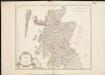
L'Ecosse divisée en shires ou comtés
1 : 845000
Scotia Regnum. [Karte], in: Gerardi Mercatoris Atlas, sive, Cosmographicae meditationes de fabrica mundi et fabricati figura, S. 100.
1 Karte aus Atlas Mercator, Gerhard Montanus, Petrus
Composite: Scotland.
1 : 450000 Robert Laurie & James Whittle
Neueste Karte von Schotland
Grosser Hand-Atlas über alle Theile der Erde in 170 Karten Meyer, J. Verlag des Bibliographischen Instituts
Nouvelle carte d'Ecosse
1 : 1400000 Orkneje (Skotsko) Chatelain, Henri-Abraham Chatelain
Airfields, UK
Great Britain. War Office. General Staff. Geographical Section
Scotland.
1 : 1950000 Mitchell, Samuel Augustus
Scotland.
1 : 1950000 Mitchell, Samuel Augustus
A new and correct map of Scotland and the Isles, containing all ye cities, market towns, boroughs &c., the principal roads, with ye computed miles from town to town
1 : 2100000
Exactissima Regni Scotiae tabula tam in septentrionalem et meridionalem quam in minores earundem provincias, insulasque ei undique praetensas accurate divisa
1 : 950000 per Nicolaum Visscher Amst. Bat. [Amsterdam] : nunc apud P. Schenk Junior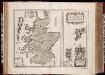
Scotia Regnvm cum insulis adjacentibus / Robertus Gordonius a Straloch descripsit
1 : 1400000 titelvariant: Scotia Regnvm; Annotatie: Met opdracht door Robertus Gordonius aan Jacobus Hamiltonius; Origineel is Blad 30 in atlas factice; Annotatie geografische gegevens: Met 2 schaalstokken Robert Gordon 1580-1661 [Amsterdam : Joan Blaeu]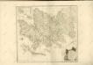

Karte von Scotland
1 : 900000 Skotsko Dorret, J. Schraembl, Franz Anton F.A. Schraembl
![Scotia Regnum [Karte] Orcades Insulae. [Nebenkarte], in: Le théâtre du monde, ou, Nouvel atlas contenant les chartes et descriptions de tous les païs de la terre, Bd. 3, S. 316.](https://images-2.georeferencer.com/images/iiif/725584208588/full/,300/0/native.jpg)

