Maps of Highland

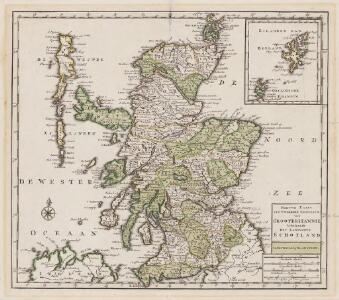
Nieuwe kaart van 't noorder gedeelte van Grootbritannie behelzelde het Koningryk Schotland
1 : 1750000 Annotatie: Uit: Nieuwe en beknopte hand-atlas ... - Amsterdam : Isaak Tirion, [na 1769] Amsterdam : Isaak Tirion
Scotia, Regnum. [Karte], in: Atlas, sive, Cosmographicae meditationes de fabrica mundi et fabricati figura, S. 83.
1 Karte aus Atlas Mercator, Gerhard

Scotland.
1 : 3000000 Seaman, James V.
[Schotland mit der Nördlichen Spitze von England]
Hand-Atlas über alle Theile der Erde nach dem neuesten Zustande und über das Weltgebäude Stieler, Adolf bei Justus Perthes
Ancient Britain II.
1 : 1830000 Society for the Diffusion of Useful Knowledge (Great Britain)
Scotland or N. Britain.
1 : 1500000 Bowen, Emanuel
Exactissima Regni Scotiae tabula tam in septentrionalem et meridionalem quam in minores earundem provincias, insulasque ei undique praetensas accurate divisa
1 : 950000 per Nicolaum Visscher Amst. Bat. [Amsterdam] : nunc apud P. Schenk Junior
Scotland.
1 : 1950000 Mitchell, Samuel Augustus
Scotland.
1 : 1950000 Mitchell, Samuel Augustus
Schottland.
1 : 1750000 Flemming, Carl
Scotia Regnum. [Karte], in: Gerardi Mercatoris Atlas, sive, Cosmographicae meditationes de fabrica mundi et fabricati figura, S. 100.
1 Karte aus Atlas Mercator, Gerhard Montanus, Petrus
Composite: Scotland.
1 : 450000 Robert Laurie & James Whittle
Scotland ancient, modern.
1 : 2200000 Patteson, Edward
Scotland (outline)
1 : 2200000 Patteson, Edward
Scotia Regnvm cum insulis adjacentibus / Robertus Gordonius a Straloch descripsit
1 : 1400000 titelvariant: Scotia Regnvm; Annotatie: Met opdracht door Robertus Gordonius aan Jacobus Hamiltonius; Origineel is Blad 30 in atlas factice; Annotatie geografische gegevens: Met 2 schaalstokken Robert Gordon 1580-1661 [Amsterdam : Joan Blaeu]
[87][87] Scotia Regnum ..., uit: Atlas sive Descriptio terrarum orbis
Annotatie: Gedigitaliseerde versie. Amsterdam. Heiloo : Picturae (vervaardiger), 2015. tiff-bestand. Gedigitaliseerd: 07-01-2015; Origineel: Universiteitsbibliotheek Vrije Universiteit (XL.05127.-) ; Netherlands; Titelpagina ontbreekt Wit, Frederik de Amsterdam : Frederick de Wit
Scotia Regnum [Karte] Orcades Insulae. [Nebenkarte], in: Novus atlas absolutissimus, Bd. 8, S. 124.
1 Karte aus Atlas Janssonius Offizin
Karte von Scotland
1 : 900000 Skotsko Dorret, J. Schraembl, Franz Anton F.A. Schraembl
Karte von Scotland
1 : 900000 Skotsko Dorret, J. Schraembl, Franz Anton F.A. Schraembl
Schotland
1 : 1380000 Shetlandy (Skotsko) bei Marco Berra
Scotland.
1 : 1930000 Tanner, Henry S.
Scotia Regnum / [Joannes Janssonius]
1 : 1300000 Annotatie: Oorspr. verschenen in: Gerardi Mercatoris et I. Hondii appendix atlas ... - Amsterdam : bey Johan Jansson, 1636; Origineel is Blad 31 in atlas factice Janssonius, Joannes (jr.) (1588-1664) Amstelodami : apud Ioannem Ianssonium
Scotia Regnum [Karte] Orcades Insulae. [Nebenkarte], in: Theatrum orbis terrarum, sive, Atlas novus, Bd. 4, S. 542.
1 Karte aus Atlas Blaeu, Joan Blaeu, Willem Janszoon
Scotia Regnum [Karte] Orcades Insulae [Nebenkarte], in: Gerardi Mercatoris et I. Hondii Newer Atlas, oder, Grosses Weltbuch, Bd. 1, S. 66.
1 Karte aus Atlas Mercator, Gerhard und Hondius, Jodocus Jansson, Jan
Scotia antiqva
2 Karten auf 1 Blatt : Kupferdruck ; Bildgrösse 42 x 54 cm Blaeu; Gordon Joan Blaeu
Partie, l'Angleterre. Europe 7.
1 : 1641836 Vandermaelen, Philippe, 1795-1869
Neueste Karte von Schotland
Grosser Hand-Atlas über alle Theile der Erde in 170 Karten Meyer, J. Verlag des Bibliographischen Instituts