Maps of Appennini
Estats de L'Eglise et de Toscane. [Karte], in: Atlas nouveau, contenant toutes les parties du monde [...], Bd. 2, S. 132.
1 Karte aus Atlas Sanson, Nicolas Jaillot, Alexis Hubert und Mortier, Pieter
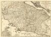
Stato Della Chiesa. Dominium Ecclesiasticum In Italia. [Karte], in: Gerardi Mercatoris et I. Hondii Newer Atlas, oder, Grosses Weltbuch, Bd. 2, S. 299.
1 Karte aus Atlas Mercator, Gerhard und Hondius, Jodocus Jansson, Jan
Stato della Chiesa con la Toscana
1 : 1035000 Annotatie: Met opdracht van Henricus Hondius; Origineel is Blad 162 in atlas factice; Annotatie geografische gegevens: Schaalstokken op de kaart: 60 Milliaria Italica communia (=10 cm), en: 12 Milliaria Germanica communia (=8,6 cm) Amstelodami : Sumptibus Ioannis Ianssonii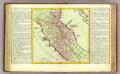
Etat de l'Eglise.
1 : 1500000 Clouet, J. B. L. (Jean-Baptiste Louis), b. 1730
Stato Della Chiesa Con La Toscana [Karte], in: Novus atlas absolutissimus, Bd. 5, S. 142.
1 Karte aus Atlas Janssonius Offizin
Italy, North Part.
1 : 2500000 Tanner, Henry S.
Stato Della Chiesa, Con La Toscana. [Karte], in: Le théâtre du monde, ou, Nouvel atlas contenant les chartes et descriptions de tous les païs de la terre, Bd. 3, S. 165.
1 Karte aus Atlas Blaeu, Willem Janszoon und Blaeu, Joan Blaeu, Willem Janszoon
Stato Della Chiesa, Con La Toscana. [Karte], in: Novus Atlas, das ist, Weltbeschreibung, Bd. 3, S. 157.
1 Karte aus Atlas Blaeu, Joan Blaeu, Willem Janszoon
STATO DELLA | CHIESA | CON LA TOSCANA
Guiljelmus Blaeu | excudit
Estats de l'Eglise et de Toscane
1 : 780000 Mollova mapová sbírka Jaillot, Jean-Baptiste-Michel Renou de Chauvigné dit Jaillot, Jean-Baptiste Michel
Stato Della Chiesa, Con La Toscana. [Karte], in: Theatrum orbis terrarum, sive, Atlas novus, Bd. 3, S. 137.
1 Karte aus Atlas Blaeu, Joan Blaeu, Willem Janszoon
X, uit: General-Karte von Mittel-Europa in 12 Blättern, im Masse 1:1.200.000 / entworfen, bearb. und hrsg. von Josef Schlacher
1 : 1200000 Annotatie: Blad 6 ontbreekt; Annotatie geografische gegevens: 21 maatstokken op blad 9; Legenda op blad 9 Wien : K.K. Militär Geografisches Institut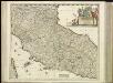
[31][31] Status Ecclesiasticus et Magnus Ducatus Thoscanae, uit: Atlas sive Descriptio terrarum orbis
Annotatie: Gedigitaliseerde versie. Amsterdam. Heiloo : Picturae (vervaardiger), 2015. tiff-bestand. Gedigitaliseerd: 07-01-2015; Origineel: Universiteitsbibliotheek Vrije Universiteit (XL.05127.-) ; Netherlands; Titelpagina ontbreekt Wit, Frederik de Amsterdam : Frederick de Wit
Italy. North Part.
1 : 2450000 Tanner, Henry S.
Italy North Part.
1 : 2450000 Tanner, Henry S.
Northern Italy.
1 : 1270000 Mitchell, Samuel Augustus
Northern Italy.
1 : 1270000 Mitchell, Samuel Augustus
Etats de l'Eglise
1 : 850000 Mollova mapová sbírka Nolin, Jean-Baptiste Nolin, Jean Baptiste II.
Status Ecclesiastici Magnique Ducatus Florentini
1 : 870000 Mollova mapová sbírka Homann, Johann Baptist Homann, Johann Baptista
Status Ecclesiastici nec non Magni Ducatus Toscanae nova tabula geographica
1 : 930000 secundum principia legitimae delineationis descripta a Tob. Majero curantibus Homannianis Heredibus. Norimbergae : Homanniani Heredes
Italy. North Part.
1 : 2500000 Mitchell, Samuel Augustus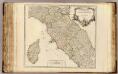
Etat de l'Eglise, Toscane et Corse.
1 : 930000 Robert de Vaugondy, Gilles, 1688-1766
Status Ecclesiastici nec non magni dvcatvs Toscanae nova tabvla geographica
1 : 937000 Papežský stát Mayer, Tobias curantibus Homannianis Heredibus
STATVS ECCLESIASTICI nec non MAGNI DVCATVS TOSCANAE NOVA TABVLA GEOGRAPHICA
1 : 960000 Papežský stát Mayer, Tobias curantibus Homannianis Heredibus
Status Ecclesiasticus et magnus ducatus Thoscanae
1 : 800000 per Fredericum de Wit [Amsterdam] : [Frederick de Wit]
Continentis Italiae Pars Media, Seu Prima Meridionalis; Ecclesiae Status Tredecim, et Magni Ducatus Toscani Dominium ac Territoria exhibens
1 : 870000 Mollova mapová sbírka Schenk, Pieter Schenk, Peter II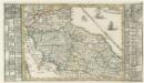
Italien Eigendlich also genandt
1 : 2900000 Mollova mapová sbírka Bodenehr, Gabriel Bodenehr, Gabriel
Stato della Chiesa
1 : 1000000 Itálie střední Hondius, Henricus sumptibus Henrici Hondii
![Estats de L'Eglise et de Toscane. [Karte], in: Atlas nouveau, contenant toutes les parties du monde [...], Bd. 2, S. 132.](https://images-2.georeferencer.com/images/iiif/460989138461/full/,300/0/native.jpg)

