Maps of Normandy
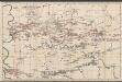
Le Duché et Gouvernement De Normandie divisée en Haute et Basse Normandie [...] [Karte], in: Atlas nouveau, contenant toutes les parties du monde [...], Bd. 1, S. 117.
1 Karte aus Atlas Sanson, Nicolas Jaillot, Alexis Hubert und Mortier, Pieter
Le Duché et gouvernement de Normandie
1 Karte : Kupferdruck ; 47 x 59 cm Jaillot A.-H. Jaillot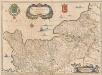
Normandia Ducatus. [Karte], in: Novus atlas absolutissimus, Bd. 4, S. 109.
1 Karte aus Atlas Janssonius Offizin
Le Duché et gouvernement de Normandie
1 Karte : Kupferdruck ; 47 x 59 cm Jaillot chez J. Cóvens et C. Mortier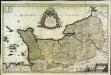
Le Duché et gouvernement de Normandie
1 Karte : Kupferdruck ; 55 x 87 cm Sanson; Jaillot chez H. Iaillot au deux Globes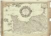
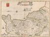
Le gouvernement general de Normandie, divisé en Haute et Basse
1 : 600000 Normandie (Francie) Fer, Nicolas de Danet, Guillaume Danet
Normandia Ducatus. [Karte], in: Gerardi Mercatoris et I. Hondii Newer Atlas, oder, Grosses Weltbuch, Bd. 2, S. 65.
1 Karte aus Atlas Mercator, Gerhard und Hondius, Jodocus Jansson, Jan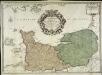
Le gouvernement general de Normandie
1 Karte : Kupferdruck ; 45 x 63 cm Desnos chez Desnos géographe ingénieur pour les globes spheres et instruments de mathématique rue St. Jacques au globe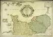
Le gouvernement general de Normandie
1 Karte : Kupferdruck ; 45 x 65 cm Fer; Danet; Starckman chez Danet gendre de l'auteur sur le pont Notre Dame a la Sphere royale
Gouvernement général de Normandie
1 Karte : Kupferdruck ; 47 x 57 cm Robert de Vaugondy G. et D. Robert de Vaugondy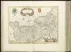
[16][16] Normandia Ducatus, uit: Atlas sive Descriptio terrarum orbis
Annotatie: Gedigitaliseerde versie. Amsterdam. Heiloo : Picturae (vervaardiger), 2015. tiff-bestand. Gedigitaliseerd: 07-01-2015; Origineel: Universiteitsbibliotheek Vrije Universiteit (XL.05127.-) ; Netherlands; Titelpagina ontbreekt Wit, Frederik de Amsterdam : Frederick de Wit
Normandia Ducatus. [Karte], in: Theatrum orbis terrarum, sive, Atlas novus, Bd. 2, S. 74.
1 Karte aus Atlas Blaeu, Joan Blaeu, Willem Janszoon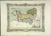
Carte des départemens de la Manche, du Calvados, de l'Orne, de l'Eure et de la Seine inférieure
1 Karte : Kupferdruck ; 22 x 32 cm, Bildgrösse 32 x 42 cm Brion de la Tour; Desnos chez le S. Desnos rue St. Jacques au globe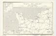
Coast of France : Dieppe to St. Brieuc
1 : 885000 Provisional ed. Inset: [Location map]. Shows main roads and railroads. Dated: 12 June 1944. United States. Office of Strategic Services. Research and Analysis Branch [Washington, D.C.] : R & A, OSS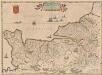
Normandia Ducatus. [Karte], in: Novus Atlas, das ist, Weltbeschreibung, Bd. 2, S. 121.
1 Karte aus Atlas Blaeu, Joan Blaeu, Willem Janszoon
Normannia ducatus, tum superior ad ortum, tum inferior ad occasum, præfectura generalis
1 Karte : Kupferdruck ; 46 x 58 cm Valck; Valck Gerard und Leonardus Valck
Normandia ducatus
1 Karte : Kupferdruck ; 37 x 51 cm Janssonius Joannes Janssonius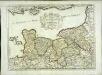
Duché et gouvernement de Normandie
1 Karte : Kupferdruck ; 37 x 50 cm Sanson; Cordier s.n.
Normandia Ducatus. [Karte], in: Le théâtre du monde, ou, Nouvel atlas contenant les chartes et descriptions de tous les païs de la terre, Bd. 2, S. 120.
1 Karte aus Atlas Blaeu, Willem Janszoon und Blaeu, Joan Blaeu, Willem Janszoon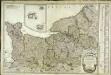
Carte du gouvernement de Normandie
1 Karte : Kupferdruck ; 47 x 64 cm Robert de Vaugondy; Fortin chés Fortin mécanicien du roy rue de la Harpe

Duché et gouvernement general de Normandie, divise en haut et bas en divers pays et balliages avec le gouvernement general de Havre de Grace
1 : 450000 par F. de Witt A Amsterdam : [F. de Wit]
Duche et gouvernement general de Normandie
1 Karte : Kupferdruck ; 48 x 59 cm Wit se vend chez J. Cóvens et C. Mortier
Duche et gouvernement general de Normandie
1 Karte : Kupferdruck ; 48 x 59 cm Wit F. de Wit
Duche et gouvernement general de Normandie
1 Karte : Kupferdruck ; 49 x 58 cm Seutter; Lotter M. Seutter
NORMANDIA | DVCATVS.
Excudit Guiljelmus Blaeu.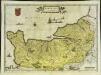
Normandia dvcatvs
1 Karte : Kupferdruck ; 37 x 51 cm Blaeu Willem Janszoon Blaeu
Carte du gouvernement de Normandie avec celui du Maine et Perche
1 Karte : Kupferdruck ; 42 x 57 cm Bonne; Santini; Remondini chez Mr. Remondini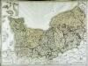
![Le Duché et Gouvernement De Normandie divisée en Haute et Basse Normandie [...] [Karte], in: Atlas nouveau, contenant toutes les parties du monde [...], Bd. 1, S. 117.](https://images-2.georeferencer.com/images/iiif/231741515740/full/,300/0/native.jpg)

