Maps of Arras

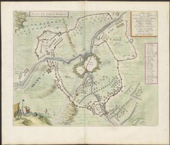
PLAN ET SIEGE D'ARRAS
[Amsterdam : Joan Blaeu]
Disegno della citta d'Arras e suo territorio
1 : 53300 Arras (Francie)
Plan de la ville et citadelle d'Arras: place forte Evêché capitalle du Comté d'Artois située sur la petite Piviere d'Escarpe
1 : 8650
[Arras et environs]
1 : 20000 Annotatie: Herdruk van originele koperplaat; Oorspr. uitg.: ca. 1850 [Paris : I.G.N.]
ATREBATVM, | Gallis ARRAS, | Belgis ATRECHT dicta
[Amsterdam : Joan Blaeu]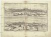
Montes, Hannoniae metropolis
Arras (Francie) Braun, Georg Hogenberg, Franz
Western Road. Secret. December 1917
1 : 10000 First World War map Western Road. Dec.1917. Secret - Not to be taken beyond Brigade H.Q. War Office
Arras Mitt Nahe anliegender Gegend
1 : 150000 Mollova mapová sbírka Bodenehr, Gabriel Bodenehr, Gabriel
Carte particuliere des environs de Lille, Tournay, Valenciennes, Bouchain, Douay, Arras, Bethune
1 : 110000 Arras (Francie) Fricx, Eugene Henry Harrewyn, Jacques chez Eugene Henry Friex
Cambrai-Saint Quentin. Scale, 1 : 100,000 or 1 inch to 1.58 miles
Cambrai-Saint Quentin.
[Abbeville - Arras]
1 Blatt : 60 x 91 cm Le Roy s.n.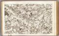
4 Abbeville.
1 : 86400 Cassini family; Cassini, Cesar-Francois, 1714-1784
Lille La Bassée

Carte particuliere des environs de Lille, Tournay, Valenciennes, Bouchain, Douay, Arras, Bethune
1 : 116600 Mollova mapová sbírka Fricx, Eugène Henry Harrewyn, Jacques Fricx, Eugené Henry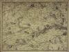
Carte particuliere des environs de Lille, Tournay, Valenciennes, Bouchain, Douay, Arras, Bethune
1 Karte : Kupferdruck ; 40 x 55 cm Fricx; Harrewijn chez Eugene Henry Fricx ruë de la Madelene
Das Kampfgebiet an der Somme
1 : 200000 Somme, řeka (Francie) Velhagen & Klasing
Map showing progress in Arras area
1 : 40000 First World War map showing progress in Arras area. War Office
Archiepiscopatvs Cameracensis
1 : 200000 Mollova mapová sbírka Blaeu, Willem Janszoon Blaeu, Willem Jansz.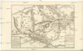
Carte Tres particuliere des Environs de Douay ou L'on voit les Lignes de Circonvalation, Comme aussy l'Innondation faite par la Scarpe
1 : 93000 Douai (Francie) Fricx, Eugene Henry Harrewyn, Jacques chez Eugene Henry Fricx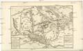
Carte Tres particuliere des Environs de Douay ou L'on voit les Lignes de Circonvalation, Comme aussy l'Innondation faite par la Scarpe
1 : 93000 Douai (Francie) Fricx, Eugene Henry Harrewyn, Jacques chez Eugene Henry Fricx
Carte du gouuernement de Lens
1 Karte : Kupferdruck ; 11 x 15 cm s.n.
L'Archevesche de Cambray [Karte], in: Gerardi Mercatoris et I. Hondii Newer Atlas, oder, Grosses Weltbuch, Bd. 2, S. 26.
1 Karte aus Atlas Mercator, Gerhard und Hondius, Jodocus Jansson, Jan

Archiepiscopatus Cameracensis. Archevesché de Cambray. [Karte], in: Le théâtre du monde, ou, Nouvel atlas contenant les chartes et descriptions de tous les païs de la terre, Bd. 2, S. 26.
1 Karte aus Atlas Blaeu, Willem Janszoon und Blaeu, Joan Blaeu, Willem Janszoon
Archiepiscopatus Cameracensis. Archebesché de Cambray. [Karte], in: Novus Atlas, das ist, Weltbeschreibung, Bd. 2, S. 26.
1 Karte aus Atlas Blaeu, Joan Blaeu, Willem Janszoon
Artesia vulgo Artois, et Sedes Belli in Picardia &c Stoel des OOrlogs in Artois en Picardy, enz
1 : 250000 Mollova mapová sbírka Allard, Abraham Allart, Abraham
Atrebates: Evesché d'Arras comté d'Artois subdivisé en toutes ses Iurisdictions scav. Gouvernance d'Arras, com.te de St Pol ... Bappaumes &c.
1 : 211000
Arras, Peronne, Noyon, uit: Le conflict mondial : front occidental
1 : 170000 Annotatie: Ontbreekt: no. 1 en 5-8 Gand : Th. de Graeve
Tabula Comitatvs Artesiae
1 : 200000 Mollova mapová sbírka Wit, Frederik de Wit, Frederick