Maps of Mont-Saint-Éloi
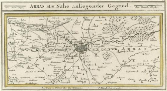
Arras Mitt Nahe anliegender Gegend
1 : 150000 Mollova mapová sbírka Bodenehr, Gabriel Bodenehr, Gabriel
PLAN ET SIEGE D'ARRAS
[Amsterdam : Joan Blaeu]
Disegno della citta d'Arras e suo territorio
1 : 53300 Arras (Francie)
Plan de la ville et citadelle d'Arras: place forte Evêché capitalle du Comté d'Artois située sur la petite Piviere d'Escarpe
1 : 8650
Western Road. Secret. December 1917
1 : 10000 First World War map Western Road. Dec.1917. Secret - Not to be taken beyond Brigade H.Q. War Office
[Arras et environs]
1 : 20000 Annotatie: Herdruk van originele koperplaat; Oorspr. uitg.: ca. 1850 [Paris : I.G.N.]
ATREBATVM, | Gallis ARRAS, | Belgis ATRECHT dicta
[Amsterdam : Joan Blaeu]
Montes, Hannoniae metropolis
Arras (Francie) Braun, Georg Hogenberg, Franz
Map showing progress in Arras area
1 : 40000 First World War map showing progress in Arras area. War Office
Das Kampfgebiet an der Somme
1 : 200000 Somme, řeka (Francie) Velhagen & Klasing
Carte Tres particuliere des Environs de Douay ou L'on voit les Lignes de Circonvalation, Comme aussy l'Innondation faite par la Scarpe
1 : 93000 Douai (Francie) Fricx, Eugene Henry Harrewyn, Jacques chez Eugene Henry Fricx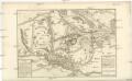
Carte Tres particuliere des Environs de Douay ou L'on voit les Lignes de Circonvalation, Comme aussy l'Innondation faite par la Scarpe
1 : 93000 Douai (Francie) Fricx, Eugene Henry Harrewyn, Jacques chez Eugene Henry Fricx
Carte du gouuernement de Lens
1 Karte : Kupferdruck ; 11 x 15 cm s.n.
Atrebates: Evesché d'Arras comté d'Artois subdivisé en toutes ses Iurisdictions scav. Gouvernance d'Arras, com.te de St Pol ... Bappaumes &c.
1 : 211000
Arras, Peronne, Noyon, uit: Le conflict mondial : front occidental
1 : 170000 Annotatie: Ontbreekt: no. 1 en 5-8 Gand : Th. de Graeve
Tabula Comitatvs Artesiae
1 : 200000 Mollova mapová sbírka Wit, Frederik de Wit, Frederick
Stanford's half-inch map of the British front in France and Flanders
1 : 126720 Shows line of battle in June 1916 and updated line of battle in June 1917.Relief shown as gradient tints.Shows: railways, roads, woods. Edward Stanford Ltd. [London] : Edward Stanford Ltd.
Flandria Gallica Continens Castellanias Insulensem Duacensem Orchianensem Civitatem Dominiumque Tornacense [Karte], in: Novus atlas absolutissimus, Bd. 3, S. 129.
1 Karte aus Atlas Janssonius Offizin
Amiens 95, uit: Special-Karte von Mittel-Europa / nach amtlichen Quellen bearbeitet von W. Liebenow
1 : 300000 titelvariant: W. Liebenow's Mittel-Europa; Annotatie: Titel boven de bladen: W. Liebenow's Mittel-Europa Johannes Wilhelm Liebenow 1822-1897 Frankfurt a. M. : Ludwig Ravenstein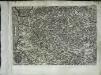
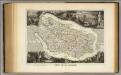
Artesia
1 Karte : Kupferdruck ; 21 x 30 cm Quad; Bussemacher Johannes Bussemacher
Atrebates
1 Karte : Kupferdruck ; 41 x 54 cm Sanson; Robert de Vaugondy chés le Sr. Robert geogr. du roi quai de l'Horloge du palais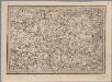
[20], uit: Hydro-Oro und Chorographische General Karte des Koenigreichs der Niederlande und der angrenzenden Länder bis Paris : mit der Angabe der Kunst und Heer-Strassen und der Entfernung der Poststationen / ... zusammengetragen und reducirt von ... Wilhelm Müller
1 : 400000 titelvariant: Generalkarte des Koenigreichs Hannover; Annotatie: 1e supplement bij: Generalkarte des Koenigreichs Hannover (1818) Müller, Wilhelm (fl. 1818) [Hannover : Wilhelm Müller]
Amiens 95, uit: [W. Liebenow's Special-Karte von Mittel-Europa]
1 : 300000 titelvariant: W. Liebenow's Mittel-Europa; Annotatie: Titel boven de bladen: W. Liebenow's Mittel-Europa Johannes Wilhelm Liebenow 1822-1897 Hannover : Hermann Oppermann
Carte d'Artois et des Environs
1 : 208000 Mollova mapová sbírka Delisle, Guillaume L'Isle, Guillaume de
Artois : Atrebatum regionis vera descriptio
1 : 310000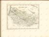
Dept. Des De La Somme.
1 : 378000 Levasseur, Victor.
Geographica Artesiæ comitatus tabula
1 Karte : Kupferdruck ; 45 x 55 cm Visscher Nicolaes Visscher
Geographica Artesiae comitatus tabula
1 : 200000 Artois (Francie) Visscher, Nicolaus per Nicolaum Visscher edita