Maps of Spain

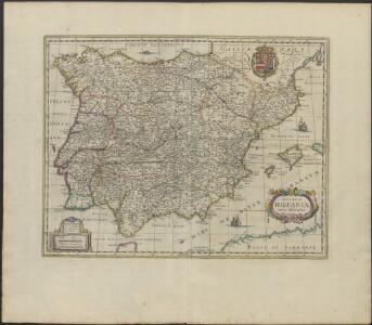
REGNORVM | HISPANIÆ | nova descriptio
Amsterdami | Apud Guiljelmum Blaeuw
L'Espagne
1 Karte : Kupferdruck ; 19 x 25 cm Crépy chez Crepy
Accuratissima totius regni Hispaniae Portugalliaeq[ue] tabula et typus novissimus
1 : 2370000 Portugalsko Wit, Frederick de x [officina Frederici de Witt
Spanien und Portugal
Stieler's Hand-Atlas Stieler, Adolf bei Justus Perthes
Hispaniarum Portugalliæque coronarum typus novus
1 Karte : Kupferdruck ; 48 x 59 cm Valck s.n.
Spanien und Portugal
1 : 2300000 entworfen und gezeichnet von C. F. Weiland L.G. Jaeger sc. Weimar : Verlag des Geograph. Instituts
Spanien und Portugal
1 : 2300000 entworfen und gezeichnet von C. F. Weiland L.G. Jaeger sc. Weimar : Verlag des Geograph. Instituts
Spanien und Portugal
Schul-Atlas über alle Theile der Erde nach dem neuesten Zustande, und über das Weltgebäude Stieler, Adolf bei Justus Perthes
Totius regnorum Hispaniae et Portugaliae descriptio / auct. F. de Wit
1 : 2500000 Annotatie: Origineel is Blad 5 in atlas factice Wit, Frederik de Gedruckt tot Amsterdam : by Frederick de Wit ...
Espagne, Portugal.
1 : 3600000 Janvier, Jean
Weg-wyzer der legertogten in Spanje en Portugaal
1 Karte : Kupferdruck ; 49 x 57 cm Allard Abraham Allard
Accuratissima totius regni Hispaniæ Portugalliæ[que] tabula et typus novissimus
1 Karte : Kupferdruck ; 48 x 57 cm Wit ex officina Frederici de Witt
Novissima regnorum Hispaniæ et Portugalliæ tabula
1 Karte : Kupferdruck ; 48 x 56 cm Homann; Funck edita per Davidem Funcken
Hispaniae et Portugalliae regna [et]c
1 Karte : Kupferdruck ; 48 x 56 cm Homann; Funck ex officina Davidis Funckii
Hispaniæ et Portugalliæ regna
1 Karte : Kupferdruck ; 45 x 55 cm Visscher s.n.
Accuratissima totius regni Hispaniæ tabula
1 Karte : Kupferdruck ; 48 x 56 cm Danckerts ex officina Justi Danckerts
Accuratissima totius regni Hispaniae tabula
1 : 2400000 1 Karte : Kupferdruck ; 48 x 56 cm Danckerts, Justus [Danckerts]
Typus Hispaniae ab Hesselo Gerardo delineata [...] [Karte], in: Novus atlas absolutissimus, Bd. 6, S. 15.
1 Karte aus Atlas Janssonius Offizin
Novissima et accuratissima regnorum Hispaniæ et Portugalliæ mappa geographica
1 Karte : Kupferdruck ; 48 x 56 cm Seutter; Probst anjezo in Verlag bey Ioh. Michael Probst chalcogr
Novissima et accuratissima regnorum Hispaniæ et Portugalliæ tabula
1 Karte : Kupferdruck ; 48 x 58 cm Wit ex officina I. Covens et C. Mortier
Novissima et accuratissima regnorum Hispaniæ et Portugalliæ tabula
1 Karte : Kupferdruck ; 48 x 58 cm Wit s.n.
Carte d'Espagne et de Portugal
1 Karte auf 6 Blatt : Kupferdruck ; 73 x 82 cm Brion de la Tour; Jean chez Jean rue Jean de Beauvais. no. 10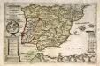
Hispaniæ et Lvsitaniæ regna. quorum potentia in orientem et occidentem longius est extensa
1 Karte : Kupferdruck ; Bildgrösse 22 x 34 cm Leopold s.n.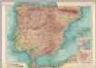
Spain and Portugal. Pergamon World Atlas.
1 : 2500000 Polish Army Topography Service
Spanien und Portugal
1 Karte : Kupferdruck ; 25 x 29 cm Sotzmann; Ramberg s.n.
Regnorum Hispaniæ et Portvgalliæ tabula generalis
1 Karte : Kupferdruck ; 45 x 57 cm Güssefeld; López chez les Heret. de Homann
Regnorum Hispaniæ et Portvgalliæ tabula generalis
1 Karte : Kupferdruck ; 45 x 57 cm Güssefeld; López chez les Heret. de Homann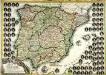
El reyno de España
1 Karte : Kupferdruck ; 51 x 73 cm Mondhare casa de L. Mondhare calle de st. Tiago
Typus Hispaniae [Karte], in: Gerardi Mercatoris et I. Hondii Newer Atlas, oder, Grosses Weltbuch, Bd. 2, S. 168.
1 Karte aus Atlas Mercator, Gerhard und Hondius, Jodocus Jansson, Jan