Maps of Spain
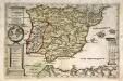
Hispaniæ et Lvsitaniæ regna. quorum potentia in orientem et occidentem longius est extensa
1 Karte : Kupferdruck ; Bildgrösse 22 x 34 cm Leopold s.n.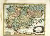
L'Espagne
1 Karte : Kupferdruck ; 19 x 25 cm Crépy chez Crepy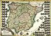
El reyno de España
1 Karte : Kupferdruck ; 51 x 73 cm Mondhare casa de L. Mondhare calle de st. Tiago
Spanien u. Portugal in vier Blättern
1 : 1820000 Portugalsko Theinert, A.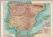
Spain and Portugal. Pergamon World Atlas.
1 : 2500000 Polish Army Topography Service
REGNORVM | HISPANIÆ | nova descriptio
Amsterdami | Apud Guiljelmum Blaeuw
Accuratissima totius regni Hispaniae Portugalliaeq[ue] tabula et typus novissimus
1 : 2370000 Portugalsko Wit, Frederick de x [officina Frederici de Witt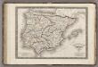
Espagne Ancienne ou Iberie.
1 : 3800000 Monin, C.V.
Novissima et accuratissima regnorum Hispaniæ et Portugalliæ mappa geographica
1 Karte : Kupferdruck ; 48 x 56 cm Seutter; Probst anjezo in Verlag bey Ioh. Michael Probst chalcogr
Novissima et accuratissima regnorum Hispaniæ et Portugalliæ tabula
1 Karte : Kupferdruck ; 48 x 58 cm Wit ex officina I. Covens et C. Mortier
Novissima et accuratissima regnorum Hispaniæ et Portugalliæ tabula
1 Karte : Kupferdruck ; 48 x 58 cm Wit s.n.
Peninsule Iberique.
1 : 2500000 Vivien St Martin, L.
Composite: Spanien, Portugal in 4 Blattern.
1 : 1500000 Vogel, C.
Spanien und Portugal
1 : 2300000 entworfen und gezeichnet von C. F. Weiland L.G. Jaeger sc. Weimar : Verlag des Geograph. Instituts
Spanien und Portugal
1 : 2350000 Cádiz (Španělsko) Weiland, Karl Ferdinand im Verlage des Geographischen Instituts
Spanien und Portugal
1 : 2350000 Cádiz (Španělsko) Weiland, Karl Ferdinand im Verlage des Geographischen Instituts
Hispaniarum Portugalliæque coronarum typus novus
1 Karte : Kupferdruck ; 48 x 59 cm Valck s.n.
L'Espagne sous les Romains 409 ans apres J.C.
1 : 4800000 Houze, Antoine Philippe
Spanien und Portugal
Stieler's Hand-Atlas Stieler, Adolf bei Justus Perthes
Novissima et accuratissima regnorum Hispaniae et Portugalliae mappa geographica
1 : 2430000 Portugalsko Seutter, Matthäus sumptibus Matthaei Seutteri

El reyno de Espan[n]a
1 Karte : Kupferdruck ; 47 x 61 cm López; Julien; Nolin en casa de Thomas Lopez pensionista de S.M.C.a, chez le Sr. Julien a l'Hotel de soubise
El reyno de Espan[n]a
1 Karte : Kupferdruck ; 48 x 61 cm Nolin; Guérard en casa del autor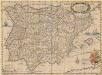
Typus Hispaniae ab Hesselo Gerardo delineata [...] [Karte], in: Novus atlas absolutissimus, Bd. 6, S. 15.
1 Karte aus Atlas Janssonius Offizin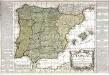
L'Espagne
1 Karte : Kupferdruck ; 46 x 54 cm Nolin; Basset; Basset chez Basset rue St. Jacques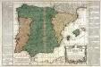
L'Espagne
1 Karte : Kupferdruck ; 45 x 54 cm Nolin; Daumont chez Daumont rue de la Feronnerie a l aigle d'or
Spanien und Portugal
1 : 2300000 entworfen und gezeichnet von C. F. Weiland L.G. Jaeger sc. Weimar : Verlag des Geograph. Instituts
Cartes Blondel : Espagne-Portugal au 2.000.000e
1 : 2000000 Blondel la Rougery. Paris Paris : Blondel La Rougery
Géographie. croquis n8, Espagne et Portugal
1 : 2000000 Molard, Jules, Commandant [Paris] : Service Géographique de l'Armée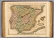
Spain, Portugal.
1 : 2450000 Lizars, Daniel
Spain, Portugal.
1 : 5200000 Arrowsmith, Aaron; Lewis, Samuel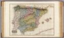
Spain and Portugal.
1 : 1920000 Pinkerton, John, 1758-1826
Spain, Portugal.
1 : 5200000 Arrowsmith, Aaron; Lewis, Samuel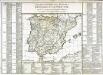
Tableau général des royaumes d'Espagne et de Portugal
1 Karte : Kupferdruck ; 34 x 43 cm, Bildgrösse 51 x 73 cm Brion de la Tour; Le Campion; Le Campion chez les Campion freres rue St. Jacques à la ville de Rouen
(L'Espagne)
1 : 12000000 Bruyset, Jean-Marie; Schneider, J. H.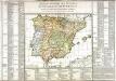
Tableau général des royaumes d'Espagne et de Portugal
1 Karte : Kupferdruck ; 34 x 43 cm, Bildgrösse 51 x 73 cm Brion de la Tour; Le Campion; Le Campion chez les Campion freres rue St. Jacques à la ville de Rouen


