Maps of Midtjylland

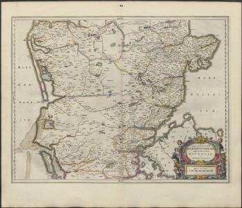
PARS AVSTRALIOR | IVTIÆ SEPTENTRIONALIS, | in qua DIOECESES | RIPENSIS | et | ARHVSIENSIS.
[Amsterdam : Joan Blaeu]
Jutia Australis, in qua Dioeceses Ripensis et Arhusiensis. [Karte], in: Novus atlas absolutissimus, Bd. 1, S. 140.
1 Karte aus Atlas Janssonius Offizin
Jutland II.
1 : 480000 Berghaus, Heinrich; Flemming, Carl; Sohr, Karl
Frederica 2, uit: Special-Karte von Mittel-Europa / nach amtlichen Quellen bearbeitet von W. Liebenow
1 : 300000 titelvariant: W. Liebenow's Mittel-Europa; Annotatie: Titel boven de bladen: W. Liebenow's Mittel-Europa Johannes Wilhelm Liebenow 1822-1897 Frankfurt a. M. : Ludwig Ravenstein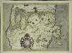
Ivtia septentrionalis
1 Karte : Kupferdruck ; 27 x 38 cm Mercator; Hondius Henricus Hondius
Ringkjöbing 1, uit: Special-Karte von Mittel-Europa / nach amtlichen Quellen bearbeitet von W. Liebenow
1 : 300000 titelvariant: W. Liebenow's Mittel-Europa; Annotatie: Titel boven de bladen: W. Liebenow's Mittel-Europa Johannes Wilhelm Liebenow 1822-1897 Frankfurt a. M. : Ludwig Ravenstein
Kolding nach der Schlacht
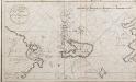
Netto afteekening van de Bay van Ebeltuds Wyk en het eyland Sampsoen in't groot
Denmark Johannes van Keulen
PARS ORIENTALIS | PRÆFECTVRÆ | HADERSLEBEN | Vulgo dictæ Baringsijßel.
Matthias Vnd Clauss Petersen | G.S. gebr. | Husumenss. sculps. [Amsterdam : Joan Blaeu]
Fionia
1 Karte : Kupferdruck ; 34 x 38 cm Mercator; Hondius Henricus Hondius
4. hadersleben, uit: Topographische Uebersichtskarte des Deutschen Reiches / herausgegeben v. d. Kartogr. Abt. d. Königl. Preuß. Landesaufnahme
1 : 200000 titelvariant: Topogr. Übersichtskarte des Deutschen Reiches; Annotatie: Titel boven bladen ook: Topogr. Übersichtskarte des Deutschen Reiches; Annotatie geografische gegevens: Op elk blad twee maatstokken: 10 Kilometer = 5,5 cm; 1 geogr. Meile = 3,6 cm; Legenda onder op elk blad Königlich Preußische Landesaufnahme. Kartographische Abtheilung [S.l : Königlich Preußische Landesaufnahme, Kartographische Abtheilung]
4. Hadersleben (papieren versie, niet op linnen), uit: Topographische Uebersichtskarte des Deutschen Reiches / herausgegeben v. d. Kartogr. Abt. d. Königl. Preuß. Landesaufnahme
1 : 200000 titelvariant: Topogr. Übersichtskarte des Deutschen Reiches; Annotatie: Titel boven bladen ook: Topogr. Übersichtskarte des Deutschen Reiches; Annotatie geografische gegevens: Op elk blad twee maatstokken: 10 Kilometer = 5,5 cm; 1 geogr. Meile = 3,6 cm; Legenda onder op elk blad Königlich Preußische Landesaufnahme. Kartographische Abtheilung [S.l : Königlich Preußische Landesaufnahme, Kartographische Abtheilung]
3. Lügumkloster, uit: Topographische Uebersichtskarte des Deutschen Reiches / herausgegeben v. d. Kartogr. Abt. d. Königl. Preuß. Landesaufnahme
1 : 200000 titelvariant: Topogr. Übersichtskarte des Deutschen Reiches; Annotatie: Titel boven bladen ook: Topogr. Übersichtskarte des Deutschen Reiches; Annotatie geografische gegevens: Op elk blad twee maatstokken: 10 Kilometer = 5,5 cm; 1 geogr. Meile = 3,6 cm; Legenda onder op elk blad Königlich Preußische Landesaufnahme. Kartographische Abtheilung [S.l : Königlich Preußische Landesaufnahme, Kartographische Abtheilung]
Topographische Karte der Umgegend von Fredericia
1 : 160000 Fredericia (Dánsko) C. Flemming
7. Hadersleben. (Germany)
1 : 100000 Reichsamt fur Landesaufnahme
Composite: 7. Hadersleben. (Germany)
1 : 100000 Reichsamt fur Landesaufnahme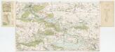
[Kaart], uit: Turistkort Silkeborg og omegn
1 : 40000 Köbenhavn : Geodaetisk Institut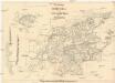
Die Festung Fredericia
1 : 70000 Fredericia (Dánsko) Brüder Bohm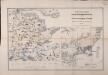
Special-Karte der Gegend zwischen Kolding, Veile, Fredericia in 1:75,000 und Plan der Festung Fredericia mit Umgegend in 1:25,000
1 : 75000 Doemming, F. v. Neumann
Plan der Gegend von Friedericia
1 : 50000 Liebenow, Wilhelm Schropp
5. Hvidding. (Germany)
1 : 100000 Reichsamt fur Landesaufnahme
Composite: 5. Hvidding. (Germany)
1 : 100000 Reichsamt fur Landesaufnahme
Meßtischblatt 25 : Aller, 1879
1 : 250000 Aller. - Aufn. 1877. - 1:25000. - [Berlin]: Reichsamt für Landesaufnahme, 1879. - 1 Kt.
Meßtischblatt 24 : Christiansfeld, 1879
1 : 250000 Christiansfeld. - Aufn. 1877. - 1:25000. - [Berlin]: Reichsamt für Landesaufnahme, 1879. - 1 Kt.
Meßtischblatt 23 : Jels, 1880
1 : 250000 Jels. - Aufn. 1878. - 1:25000. - [Berlin]: Reichsamt für Landesaufnahme, 1880. - 1 Kt.
Meßtischblatt 22 : Rödding, 1880
1 : 250000 Rödding. - Aufn. 18877/78. - 1:25000. - [Berlin]: Reichsamt für Landesaufnahme, 1880. - 1 Kt.
Meßtischblatt 21 : Hügum, 1878
1 : 250000 Hügum. - Aufn. 1878. - 1:25000. - [Berlin]: Reichsamt für Landesaufnahme, 1878. - 1 Kt.
Meßtischblatt 16 : Skudstrup, 1880
1 : 250000 Skudstrup. - Aufn. 1878. - 1:25000. - [Berlin]: Reichsamt für Landesaufnahme, 1880. - 1 Kt.
Meßtischblatt 15 : Schottburg, 1880
1 : 250000 Schottburg. - Aufn. 1878. - 1:25000. - [Berlin]: Reichsamt für Landesaufnahme, 1880. - 1 Kt.