Maps of Horsens Municipality

Frederica 2, uit: Special-Karte von Mittel-Europa / nach amtlichen Quellen bearbeitet von W. Liebenow
1 : 300000 titelvariant: W. Liebenow's Mittel-Europa; Annotatie: Titel boven de bladen: W. Liebenow's Mittel-Europa Johannes Wilhelm Liebenow 1822-1897 Frankfurt a. M. : Ludwig Ravenstein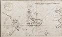
Netto afteekening van de Bay van Ebeltuds Wyk en het eyland Sampsoen in't groot
Denmark Johannes van Keulen
Topographische Karte der Umgegend von Fredericia
1 : 160000 Fredericia (Dánsko) C. Flemming
Kolding nach der Schlacht
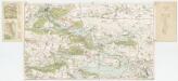
[Kaart], uit: Turistkort Silkeborg og omegn
1 : 40000 Köbenhavn : Geodaetisk Institut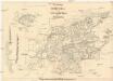
Die Festung Fredericia
1 : 70000 Fredericia (Dánsko) Brüder Bohm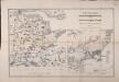
Special-Karte der Gegend zwischen Kolding, Veile, Fredericia in 1:75,000 und Plan der Festung Fredericia mit Umgegend in 1:25,000
1 : 75000 Doemming, F. v. Neumann
Plan der Gegend von Friedericia
1 : 50000 Liebenow, Wilhelm Schropp
Meßtischblatt 16 : Skudstrup, 1880
1 : 250000 Skudstrup. - Aufn. 1878. - 1:25000. - [Berlin]: Reichsamt für Landesaufnahme, 1880. - 1 Kt.
Attaco, e presa di Fredericsodde fatta dal conte Wrangel generale del re di Svetia l'anno 1657 adi 24 ottobre
Fredericia (Dánsko)
Jutland II.
1 : 480000 Berghaus, Heinrich; Flemming, Carl; Sohr, Karl
PARS AVSTRALIOR | IVTIÆ SEPTENTRIONALIS, | in qua DIOECESES | RIPENSIS | et | ARHVSIENSIS.
[Amsterdam : Joan Blaeu]
Jutia Australis, in qua Dioeceses Ripensis et Arhusiensis. [Karte], in: Novus atlas absolutissimus, Bd. 1, S. 140.
1 Karte aus Atlas Janssonius Offizin
Fionia
1 Karte : Kupferdruck ; 34 x 38 cm Mercator; Hondius Henricus Hondius
Composite: 7. Hadersleben. (Germany)
1 : 100000 Reichsamt fur Landesaufnahme
Meßtischblatt 15 : Schottburg, 1880
1 : 250000 Schottburg. - Aufn. 1878. - 1:25000. - [Berlin]: Reichsamt für Landesaufnahme, 1880. - 1 Kt.
7. Hadersleben. (Germany)
1 : 100000 Reichsamt fur Landesaufnahme
Jütland

Composite: Jutland.
1 : 480000 Flemming, Carl
Tabula generalis Iutiae
1 : 470000 Dánsko Homann, Johann Baptist J. B. Homann
Jütland
1 : 480000 Jutský poloostrov (Dánsko a Německo) C. Flemming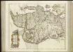
[65][65] Lutiae tabula ..., uit: Atlas sive Descriptio terrarum orbis
Annotatie: Gedigitaliseerde versie. Amsterdam. Heiloo : Picturae (vervaardiger), 2015. tiff-bestand. Gedigitaliseerd: 07-01-2015; Origineel: Universiteitsbibliotheek Vrije Universiteit (XL.05127.-) ; Netherlands; Titelpagina ontbreekt Wit, Frederik de Amsterdam : Frederick de Wit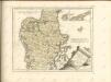


IVTIA, | olim | CIMBRICA | CHERSONESVS.
[Amsterdam : Joan Blaeu]
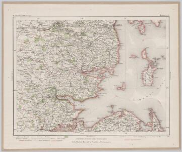
Kongeriget Danmark
1 : 500000 Bornholm (Dánsko) Generalstabens topografiske afdeling
Kongeriget Danmark
1 : 500000 Bornholm (Dánsko) Generalstabens topografiske afdeling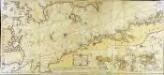
Söe=kaart over Kattegattet
1 Karte auf 2 Blatt : Kupferdruck ; 60 x 135 cm Akeleye; Schmidt s.n.
Denmark.
1 : 630000 Pinkerton, John, 1758-1826
Denmark.
1 : 1800000 Arrowsmith, Aaron; Lewis, Samuel