Maps of Alsace

Alsatia superior cu[m] Suntgoia [et] Brisgoia
1 Karte : Kupferdruck ; 34 x 46 cm Mercator s.n.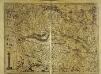
Alsatia superior cu[m] Suntgoia [et] Brisgoia
1 Karte : Kupferdruck ; 34 x 47 cm Hondius; Mercator Jodocus Hondius
Alsatia superior cu[m] Suntgoia [et] Brisgoia
1 Karte : Kupferdruck ; 35 x 46 cm Mercator; Hondius sumptibus Henrici Hondij
Alsatia Superior cum Svntgoia et Brisgoia
1 : 270000 Mollova mapová sbírka Schenk, Pieter Schenk, Peter I
Alsatia Superior cum Svntgoia et Brisgoia
1 : 270000 Mollova mapová sbírka Mercator, Gerhard Janssonius, Johannes I
Alsatia superior cu[m] Suntgoa et Brisgoia
1 Karte : Kupferdruck ; 17 x 24 cm Mercator Cloppenburgh
Alsatia superior cum Suntgoia &. Brisgoia. [Karte], in: Gerardi Mercatoris Atlas, sive, Cosmographicae meditationes de fabrica mundi et fabricati figura, S. 367.
1 Karte aus Atlas Mercator, Gerhard Montanus, Petrus
Alsatia superior cum Suntgoia &. Brisgoia. [Karte], in: Gerardi Mercatoris et I. Hondii Newer Atlas, oder, Grosses Weltbuch, Bd. 1, S. 250.
1 Karte aus Atlas Mercator, Gerhard und Hondius, Jodocus Jansson, Jan
La Haute Alsace, le Suntgow et le Brisgow
1 Blatt : 52 x 38 cm de Fer
Superioris Alsatiae nec non Brisigaviae et Suntgaviae Geographica Tabula
1 : 280000 Mollova mapová sbírka Visscher, Nicolaes Jansz. Schenk, Peter II

Superioris Alsatiæ nec non Brisigaviæ et Suntgaviæ geographica tabula
1 Karte : Kupferdruck ; 45 x 55 cm Visscher; Schenk nunc apud Petrum Schenk jun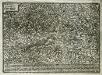
Elsatia svperior
1 Karte : Kupferdruck ; 17 x 27 cm Quad Johannes Bussemacher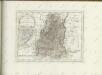

Sequani Latobrigi
1 Karte : Kupferdruck ; 40 x 43 cm Sanson; Robert de Vaugondy; Laleman chés le Sr. Robert geog. du roi quai de l'horloge du Palais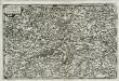
Alsatia svperior
1 Karte : Kupferdruck ; 14 x 22 cm Lambert Andreae
L'Alsazia diuisa nel Langrauiato dell'Alta e della Bassa Alsazia, nella Suntgouia, nell'Ortnauia, e nella Brisgouia
Mollova mapová sbírka Cantelli, Giacomo Donia, Francesco De Rossi, Giovanni Giacomo
Sequani Latobrigi
1 Karte : Kupferdruck ; 40 x 43 cm Sanson; Robert de Vaugondy; Laleman chés le Sr. Robert geog. du roi quai de l'horloge du Palais
Part Septentr. de l'Evesché de Basle et Partie de l'Eveché de Constance. Haute Alsace, Sungow, Brisgow &c.
1 : 240000 Mollova mapová sbírka Sanson, Nicolas Lalleman, N. Sanson, Nicolas
Freiburg
1 : 200000 Herder, Bartholomew
Imp. Caes. Carolo VI. Avgvsto pio victori gentis svae sideri felicissimo chorographiam hanc exhibentem primar. regionvm Habspvrgicar. sitvm positvmq. brevibvs exterarvm ditionvm intervallis vt permistvm et implicatvm ita variis tvrbis expositvm nec non vltimos Imperii Germ. terminos perpetva transitvvm obsidionvm Hibernorvm coactionvm vexatione agitatos antiqvae fidei et invictae testes pietatis svpplexdicat provincia Brisgoia
1 : 42000 Homann, Johann Baptist Ioh. Bapt. Homann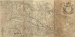
Alsatia Landgraviatus, cum Svntgoia et Brisgoia
1 : 250000 Mollova mapová sbírka Mercator, Gerhard Blaeu, Joan I.
Alsatia tem Svperior, quam Inferior una cum Svndgovia
1 : 120000 Mollova mapová sbírka Homann, Johann Baptist Homann, Johann Baptista - dědici
Ganz neue Vorstellung des Rhein_Stroms von Basel bis Coblenz...
Dept. Du Haut Rhin.
1 : 571000 Levasseur, Victor.
Département du Haut Rhin
1 Karte : Kupferdruck ; 48 x 48 cm Houdan au bureau de l'atlas national rue de la Harpe no. 26, et au depôt de cet atlas rue de la Monnoye no. 5
Carte du chemin de fer de Strasbourg à Bâle
1 : 80000 Lithographie de Ve Levrault

Carte du chemin de fer de Strasbourg à Bâle
1 : 80000 Lithographie de Ve Levrault
![Alsatia superior cu[m] Suntgoia [et] Brisgoia](http://biblio.unibe.ch/web-apps/maps/zoomify.php?pic=Ryh_2611_5.jpg&col=ryh)

