Maps of Haut-Rhin
Dept. Du Haut Rhin.
1 : 571000 Levasseur, Victor.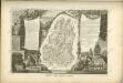

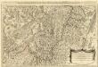
Alsatia tem Svperior, quam Inferior una cum Svndgovia
1 : 120000 Mollova mapová sbírka Homann, Johann Baptist Homann, Johann Baptista - dědici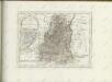

Département du Haut Rhin
1 Karte : Kupferdruck ; 35 x 39 cm Capitaine s.n.
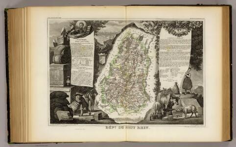
Département du Haut Rhin
1 Karte : Kupferdruck ; 48 x 48 cm Houdan au bureau de l'atlas national rue de la Harpe no. 26, et au depôt de cet atlas rue de la Monnoye no. 5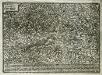
Elsatia svperior
1 Karte : Kupferdruck ; 17 x 27 cm Quad Johannes Bussemacher
La Haute Alsace, le Suntgow et le Brisgow
1 Blatt : 52 x 38 cm de Fer
L'Alsazia diuisa nel Langrauiato dell'Alta e della Bassa Alsazia, nella Suntgouia, nell'Ortnauia, e nella Brisgouia
Mollova mapová sbírka Cantelli, Giacomo Donia, Francesco De Rossi, Giovanni Giacomo
Part Septentr. de l'Evesché de Basle et Partie de l'Eveché de Constance. Haute Alsace, Sungow, Brisgow &c.
1 : 240000 Mollova mapová sbírka Sanson, Nicolas Lalleman, N. Sanson, Nicolas
Sequani Latobrigi
1 Karte : Kupferdruck ; 40 x 43 cm Sanson; Robert de Vaugondy; Laleman chés le Sr. Robert geog. du roi quai de l'horloge du Palais
Alsatia superior cu[m] Suntgoia [et] Brisgoia
1 Karte : Kupferdruck ; 34 x 46 cm Mercator s.n.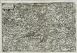
Alsatia svperior
1 Karte : Kupferdruck ; 14 x 22 cm Lambert Andreae
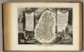
Departement du Haut Rhin
1 Karte : Kupferdruck ; 16 x 14 cm au dépot de l'Atlas national rue de la Monnoye no. 5
Partie de la Haute Alsace le Suntgaw, et le Brisgaw Partie du Canton de Basle et du Cours du Rhein ou sont les Valles de Brisac Fribourg, Colmars Huningue Befort et Basle
1 : 160000 Mollova mapová sbírka Baillieul, Gaspard Bailleul, Gaspard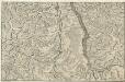
Le Cours du Rhein, depuis Spire jusqu'a Mayence
1 : 180000 Mollova mapová sbírka Fer, Nicolas de Starckman, P. Fer, Nicolas de
Alsatia superior cu[m] Suntgoa et Brisgoia
1 Karte : Kupferdruck ; 17 x 24 cm Mercator Cloppenburgh
Le Theatre de la Guerre Sur le Haut Rhein
1 : 142000 Mollova mapová sbírka Sanson, Guillaume
Sequani Latobrigi
1 Karte : Kupferdruck ; 40 x 43 cm Sanson; Robert de Vaugondy; Laleman chés le Sr. Robert geog. du roi quai de l'horloge du Palais
Alasatia superior et inferior III. tabulis delineata, 1
1 Blatt : 62 x 62 cm s.n.
Colmar 140, uit: Special-Karte von Mittel-Europa / nach amtlichen Quellen bearbeitet von W. Liebenow
1 : 300000 titelvariant: W. Liebenow's Mittel-Europa; Annotatie: Titel boven de bladen: W. Liebenow's Mittel-Europa Johannes Wilhelm Liebenow 1822-1897 Frankfurt a. M. : Ludwig Ravenstein
Freiburg
1 : 200000 Herder, Bartholomew
Colmar 140, uit: [W. Liebenow's Special-Karte von Mittel-Europa]
1 : 300000 titelvariant: W. Liebenow's Mittel-Europa; Annotatie: Titel boven de bladen: W. Liebenow's Mittel-Europa Johannes Wilhelm Liebenow 1822-1897 Hannover : Hermann Oppermann
Carte du chemin de fer de Strasbourg à Bâle
1 : 80000 Lithographie de Ve Levrault
Topographische Karte der Schweiz
1 : 100000 25 Karten vermessen und hrsg. auf Befehl der Eidgenössischen Behörden ; aufgenommen unter der Aufsicht des Generals G.H. Dufour Eidg. Topographisches Bureau, [Genève], [später: Bern]
Le cours du Rhin de Bâle à Hert près Philisbourg contenant l'Alsace et partie du Brisgau, 1
1 Blatt : 76 x 52 cm Le Rouge
Belfort, Basel
1 : 100000 1 Karte par Aug. Jaccard et Alb. Muller [i.e. Müller] [Wurster & Randegger], [Winterthur]
Blatt II: Belfort, Basel, uit: Topographische Karte der Schweiz / vermessen und hrsg. ... unter Aufsicht des Generals G.H. Dufour
1 : 100000 Annotatie: Met plaatsnamenregister (bl. V), bladwijzer (bl. XXI) en hoogteregister (bl. XXV); Voor aanwezige bladen zie overzichtsblad Dufour, G. H. [Bern : Eidg. Topogr. Bureau]
Carte du chemin de fer de Strasbourg à Bâle
1 : 80000 Lithographie de Ve Levrault