Maps of British Isles

Pas-caart van 't Canaal
1 Karte : Kupferdruck ; 44 x 54 cm Doncker bij Hendrick Doncker boekverkooper en graadbooghmaecker inde Nieuwbrughsteegh in 't Stuurmans gereedtschap
Carte générale des Iles Britanniques
1 : 2750000 par A.H. Brué Paris : chez l'auteur [etc.]
Carte de l' Angleterre
1 : 5900000 Velká Británie Delamarche, Francois Alexander
Regno Unito della Gran Brettagna e dell'Irlanda.
1 : 2500000 Picquet, C.
Karte des Brittischen Reichs
1 : 2700000 Irsko Brué, Adrien Hubert bey Artaria et Comp.

Pas-Caart vant Canaal 't Amsterdam. [Karte], in: De Nieuwe Groote Vermeerderde Zee-Atlas ofte Water-Werelt, S. 41.
1 Karte aus Atlas Doncker, Hendrick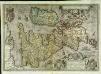
Angliae, Scotiae, et Hiberniæ, sive Britannicar: insularum descriptio
1 Karte : Kupferdruck ; 33 x 47 cm Janssonius excudebat Ioannes Ianssonius
Angliae, Scotiae, et Hiberniae, sive Britannicar: insvlarvm descriptio
1 Karte : Kupferdruck ; 33 x 48 cm Ortelius s.n.
Angliae, Scotiae, et Hiberniae, sive Britannicar: insvlarvm descriptio
1 Karte : Kupferdruck ; 33 x 49 cm Ortelius s.n.
Grossbritannien, Irland.
1 : 2500000 Andree, Richard
Pascaart Vant Canaal Tuẞchen Engelant en Vrancryck [...] [Karte], in: Het vijfde Deel Des Grooten Atlas : Vervatende De Water-Weereld, S. 160.
1 Karte aus Atlas Jansson, Jan Jansson, Jan
Die Britischen Jnseln England, Schotland, Jreland
Stieler's Hand-Atlas Stieler, Adolf bei Justus Perthes
British Isles.
1 : 2500000 Andree, Richard; Times (London, England)
Map of the British Isles.
1 : 3500000 Warner & Beers
British Isles.
1 : 4100000 Cornell, S. S. (Sarah S.)
Iles Britanniques, chemins de fer, canaux.
1 : 2700000 Garnier, F. A., 1803-1863
Iles Britanniques.
1 : 2900000 Garnier, F. A., 1803-1863
British Isles.
1 : 9300000 Fenner, Rest.
Gt. Britain, Ireland.
1 : 1800000 Robert Laurie & James Whittle
A compleat map of the British Isles.
1 : 2200000 Kitchin, Thomas
[Grossbritannien; England, Scotland und Ireland]
Geographischer Atlas über alle Theile der Erde Ziegler, Jakob Melchior Verlag von Dietrich Reimer
Iles Britanniques.
1 : 2470000 Levasseur, E.
Pascaart Vant Canaal [...] Tabula Hydrographica Freti seu Canalis [...] quod est Inter Angliam et Galliam, nec non Hiberniam et Scotiam [...] [Karte], in: Novus atlas absolutissimus, Bd. 9, S. 213.
1 Karte aus Atlas Janssonius Offizin
British Isles railways.
1 : 1800000 Philip, George
Carte des isles Britanniques et de la Manche
1 Karte : Kupferdruck ; 72 x 49 cm Brion de la Tour; Esnault; Rapilly chez Esnauts et Rapilly rue S. Jacques à la ville de Coutances
Grossbritanien und Irrland
Allgemeiner Atlas [Walch, Johannes] im Verlag bei Johannes Walch
Iles Britanniques.
1 : 2500000 Picquet, C.
Die Brittischen Inseln
Schul-Atlas über alle Theile der Erde nach dem neuesten Zustande, und über das Weltgebäude Stieler, Adolf bei Justus Perthes
The British Isles. (with) inset map of the Shetland Islands.
1 : 3801600 Tallis, J. & F.
Great Britain, Ireland.
1 : 5500000 Huntington, Nathaniel G. (Nathaniel Gilbert), 1785-1848
British Isles.
1 : 6200000 Worcester, Joseph E.
Tabula novissima accuratissima regnorum Angliæ, Scotiæ Hiberniæ
1 Karte : Kupferdruck ; 56 x 48 cm Lotter Tobias Konrad Lotter
Tabula novissima accuratissima regnorum Angliæ, Scotiæ Hiberniæ
1 Karte : Kupferdruck ; 57 x 48 cm Seutter Matthäus Seutter
Carte du gouvernement militaire d'Angleterre
1 Karte : Kupferdruck ; 16 x 15 cm, Bildgrösse 35 x 46 cm Châtelain s.n.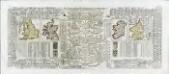
Nouvelle carte pour introduire a la geographie et a la genealogie des rois d'Angleterre et d'Ecosse
4 Karten auf 2 Blättern : Kupferdruck ; Bildgrösse 38 x 92 cm Châtelain s.n.


