Maps of British Isles

Grossbritannien, Irland.
1 : 2500000 Andree, Richard
Carte des isles Britanniques et de la Manche
1 Karte : Kupferdruck ; 72 x 49 cm Brion de la Tour; Esnault; Rapilly chez Esnauts et Rapilly rue S. Jacques à la ville de Coutances
Iles Britanniques.
1 : 2950000 Montemont, A.
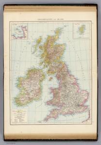
Grossbritannien, Ireland.
1 : 3900000 Radefeld, Carl Christian Franz, 1788-1874
Géographie. croquis n12, Iles britanniques
1 : 2000000 Lambin, Capitaine 18..-.... [Paris] : Service Géographique de l'Armée
Ethnographic, Gt. Brit., Ireland.
1 : 1850000 Kombst, Gustaf
Britain.
1 : 4500000 Cummings, J. A. (Jacob Abbot)
British Isles.
1 : 1680000 Pinkerton, John, 1758-1826
Angleterre, Ecosse, Irelande.
1 : 6000000 Delamarche, Charles Francois; Lattre, Jean
Carte générale des isles britanniques
1 Karte : Kupferdruck ; 76 x 51 cm Hérisson; Perrier; Basset; Basset chez Basset rue St. Jacques no. 670
General=Karte von Grossbritannien und Ireland
1 Karte : Kupferdruck ; 27 x 23 cm Reilly F. J. J. von Reilly
Mappa insularum Britannicarum antiquarum
1 Karte : Kupferdruck ; 32 x 21 cm Bonne; Perrier; André s.n.
Carte des royaumes d'Angleterre, d'Ecosse et d'Irlande
1 Karte : Kupferdruck ; 31 x 21 cm Bonne; Perrier s.n.
Des isles Britanniques
1 Karte : Kupferdruck ; 31 x 29 cm, Bildgrösse 32 x 55 cm Clouet Mondhare
Great Britain and Ireland. Pergamon World Atlas.
1 : 2500000 Polish Army Topography Service
Carte des isles Britanniques qui renferment les royaumes d'Angleterre d'Ecosse [et] d'Irlande
1 Karte : Kupferdruck ; 53 x 59 cm Robert de Vaugondy; Beaublé; Fortin; Kitchin chés Fortin ingénieur du roi pour les globes et sphéres rue de la Harpe près celle du Foin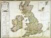
Carte des isles Britanniques qui renferment les royaumes d'Angleterre d'Ecosse [et] d'Irlande
1 Karte : Kupferdruck ; 53 x 59 cm Robert de Vaugondy; Beaublé; Delamarche; Kitchin chez le Sr. Delamarche géographe rue du Foin St. Jacques au collège de m.tre Gervais
Grossbritannien u. Irland.
1 : 2500000 Stein, Christ. Gottfr. Dan.

Pas-caart van 't Canaal
1 Karte : Kupferdruck ; 44 x 54 cm Doncker bij Hendrick Doncker boekverkooper en graadbooghmaecker inde Nieuwbrughsteegh in 't Stuurmans gereedtschap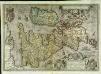
Angliae, Scotiae, et Hiberniæ, sive Britannicar: insularum descriptio
1 Karte : Kupferdruck ; 33 x 47 cm Janssonius excudebat Ioannes Ianssonius
Angliae, Scotiae, et Hiberniae, sive Britannicar: insvlarvm descriptio
1 Karte : Kupferdruck ; 33 x 48 cm Ortelius s.n.
Angliae, Scotiae, et Hiberniae, sive Britannicar: insvlarvm descriptio
1 Karte : Kupferdruck ; 33 x 49 cm Ortelius s.n.
Map of the British Isles.
1 : 3500000 Warner & Beers
British Isles.
1 : 4100000 Cornell, S. S. (Sarah S.)
Iles Britanniques, chemins de fer, canaux.
1 : 2700000 Garnier, F. A., 1803-1863
Iles Britanniques.
1 : 2900000 Garnier, F. A., 1803-1863
British Isles.
1 : 9300000 Fenner, Rest.
Charte der vereinigten Königreiche Grosbritanien und Ireland
1 Karte : Kupferdruck ; 59 x 47 cm Weidner im Verlage des Industrie Comptoirs
Grossbritannien und Irland
1 Karte : Kupferdruck ; 29 x 25 cm Sotzmann; Jättnig s.n.
Gt. Britain, Ireland.
1 : 1800000 Robert Laurie & James Whittle
A compleat map of the British Isles.
1 : 2200000 Kitchin, Thomas
A compleat map of the British Isles or Great Britain and Ireland
1 Karte : Kupferdruck ; 59 x 46 cm Sayer publish'd by Rob.t Sayer no. 53 Fleet Street as the act directs
Carte réduite des isles Britanniques
1 Karte : Kupferdruck ; 85 x 53 cm Bellin; Haussard s.n.