Maps of powiat ostrowski
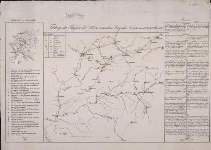
Feldzug der Russen und Polen zwischen Bug und Narew vom 13ten bis 26sten Mai 1831

Warszawa

69. Friedrichshof, uit: Topographische Uebersichtskarte des Deutschen Reiches / herausgegeben v. d. Kartogr. Abt. d. Königl. Preuß. Landesaufnahme
1 : 200000 titelvariant: Topogr. Übersichtskarte des Deutschen Reiches; Annotatie: Titel boven bladen ook: Topogr. Übersichtskarte des Deutschen Reiches; Annotatie geografische gegevens: Op elk blad twee maatstokken: 10 Kilometer = 5,5 cm; 1 geogr. Meile = 3,6 cm; Legenda onder op elk blad Königlich Preußische Landesaufnahme. Kartographische Abtheilung [S.l : Königlich Preußische Landesaufnahme, Kartographische Abtheilung]
Drogiczyn
1 : 75000 Drohiczyn-oblast (Polsko) Herwegg, J. K. u. k. Militärgeographisches Institut
Sraženīe pri Grochově
Polen Grochów Novemberaufstand <1830-1831>
Sraženīe pri Ostrolenkě
Polen Ostrołęka Novemberaufstand <1830-1831>
Sraženīe pri Vavrě
Polen Novemberaufstand <1830-1831>
Schema Pultusskago sraž.
Polen Pułtusk Napoleonische Kriege
Warsaw = Warszawa
1 : 17000 Clarke, W. B Published under the superintendence of the Society for the Diffusion of Useful Knowledge [by] Baldwin & Cradock
Warschau
1 : 200000 Warschau
Varsovie superficie 1,900,000 toises
1 : 12500 Oriented with north toward the lower right. Reproduced from an engraving in the collection of Historic Urban Plans. Indexed for points of interest. Tardieu, P. F. (Pierre François), 1757-1822 Ithaca, N.Y. : Historic Urban Plans
Šturm Pragi
Polen Warschau-Praga Kościuszko-Aufstand <1794> Suvorov, Aleksandr V.
Meßtischblatt 2791 : Flammberg, 1940
1 : 250000 Flammberg. - Aufn. 1910, bericht. 1927. - 1:25000. - [Berlin]: Reichsamt für Landesaufnahme, 1940. - 1 Kt.
Plan de Varsovie
1 : 17000 Rizzi-Zannoni, Giovanni Antonio, 1736-1814 [s.n. ]
Plan de la ville de Varsovie : dedie A. S. Mavgvste III roi de Pologne Electevr de Saxe
1 : 6600 Ricaud de Tiregale, Pierre [s.n. ]
[Warschau]
1 : 350000 Warschau Belagerung, Weltkrieg <1914-1918>
Obwod Białostocki
Białystok-oblast (Polsko)
Sect. 11: Allenstein, uit: Geologische Karte des Deutschen Reichs in 27 Blaettern / [von] Richard Lepsius ; Red. von C. Vogel
1 : 500000 Annotatie: Blad 18 ontbreekt; Een aantal bladen op linnen; Een aantal bladen gereviseerd 1913-1914; Annotatie geografische gegevens: Met schaalstokken o.a. in kilometers; Legenda Carl Vogel 1828-1897 Gotha : Justus Perthes
Warszawa, Brest-Litowsk, Radom, Lublin, Kielze, Tomaszów

Bialystok 41, uit: Special-Karte von Mittel-Europa / nach amtlichen Quellen bearbeitet von W. Liebenow
1 : 300000 titelvariant: W. Liebenow's Mittel-Europa; Annotatie: Titel boven de bladen: W. Liebenow's Mittel-Europa Johannes Wilhelm Liebenow 1822-1897 Frankfurt a. M. : Ludwig Ravenstein
Siedlee 53, uit: Special-Karte von Mittel-Europa / nach amtlichen Quellen bearbeitet von W. Liebenow
1 : 300000 titelvariant: W. Liebenow's Mittel-Europa; Annotatie: Titel boven de bladen: W. Liebenow's Mittel-Europa Johannes Wilhelm Liebenow 1822-1897 Frankfurt a. M. : Ludwig Ravenstein
Neidenburg 40, uit: Special-Karte von Mittel-Europa / nach amtlichen Quellen bearbeitet von W. Liebenow
1 : 300000 titelvariant: W. Liebenow's Mittel-Europa; Annotatie: Titel boven de bladen: W. Liebenow's Mittel-Europa Johannes Wilhelm Liebenow 1822-1897 Frankfurt a. M. : Ludwig Ravenstein

Mapa fizyczna okolic Warszawy
1 : 400000 Varšava-oblast (Polsko) Inst. Wojsk. Geograficznego
Warschau 52, uit: Special-Karte von Mittel-Europa / nach amtlichen Quellen bearbeitet von W. Liebenow
1 : 300000 titelvariant: W. Liebenow's Mittel-Europa; Annotatie: Titel boven de bladen: W. Liebenow's Mittel-Europa Johannes Wilhelm Liebenow 1822-1897 Frankfurt a. M. : Ludwig Ravenstein
[Tykotzin, Białystok, Zabłudowo, Mazowieck, Bielsk, Narew, Ciechanowiec, Bócki, Orla]
1 : 100000 Białystok-oblast (Polsko)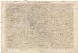
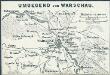
Karte der Umgegend von Warschau
1 : 100000 Varšava-oblast (Polsko) Kartogr. Abteilung des Stellvertretenden Generalstabes des Armee
Die Eroberung von Neu-Georgiewsk. (19. August 1915.)
Nowy Dwór Mazowiecki- Modlin Festung, Eroberung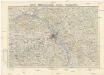
Mapa topograficzna okolic Warszawy
1 : 100000 Varšava-oblast (Polsko) Wojskowy instytut geograficzny