Maps of Podlachian

Obwod Białostocki
Białystok-oblast (Polsko)
Bialystok 41, uit: Special-Karte von Mittel-Europa / nach amtlichen Quellen bearbeitet von W. Liebenow
1 : 300000 titelvariant: W. Liebenow's Mittel-Europa; Annotatie: Titel boven de bladen: W. Liebenow's Mittel-Europa Johannes Wilhelm Liebenow 1822-1897 Frankfurt a. M. : Ludwig Ravenstein
[Tykotzin, Białystok, Zabłudowo, Mazowieck, Bielsk, Narew, Ciechanowiec, Bócki, Orla]
1 : 100000 Białystok-oblast (Polsko)
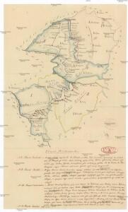
Feldzug der Russen und Polen zwischen Bug und Narew vom 13ten bis 26sten Mai 1831

Brzesc nad Bugiem

Siedlee 53, uit: Special-Karte von Mittel-Europa / nach amtlichen Quellen bearbeitet von W. Liebenow
1 : 300000 titelvariant: W. Liebenow's Mittel-Europa; Annotatie: Titel boven de bladen: W. Liebenow's Mittel-Europa Johannes Wilhelm Liebenow 1822-1897 Frankfurt a. M. : Ludwig Ravenstein
69. Friedrichshof, uit: Topographische Uebersichtskarte des Deutschen Reiches / herausgegeben v. d. Kartogr. Abt. d. Königl. Preuß. Landesaufnahme
1 : 200000 titelvariant: Topogr. Übersichtskarte des Deutschen Reiches; Annotatie: Titel boven bladen ook: Topogr. Übersichtskarte des Deutschen Reiches; Annotatie geografische gegevens: Op elk blad twee maatstokken: 10 Kilometer = 5,5 cm; 1 geogr. Meile = 3,6 cm; Legenda onder op elk blad Königlich Preußische Landesaufnahme. Kartographische Abtheilung [S.l : Königlich Preußische Landesaufnahme, Kartographische Abtheilung]
Germany 1:100,000 , Series GSGS 2739, (Sheet 17E)
This map series of which this is part - Germany 1:100,000 , Series GSGS 2739 - are reproductions of German mapping with English marginalia. Great Britain. General Staff. Geographical Section. [London] : [GSGS, War Office]
170.1. Bialla (202. Gehsen). (Germany)
1 : 100000 Reichsamt fur Landesaufnahme
202.1. (170. Bialla). Gehsen. (Germany)
1 : 100000 Reichsamt fur Landesaufnahme
Composite: 170.1. Bialla (202. Gehsen) (Germany)
1 : 100000 Reichsamt fur Landesaufnahme
Composite: 202.1. (170. Bialla). Gehsen. (Germany)
1 : 100000 Reichsamt fur Landesaufnahme
171. Ostrokollen. (Germany)
1 : 100000 Reichsamt fur Landesaufnahme
170. Bialla (202. Gehsen). (Germany)
1 : 100000 Reichsamt fur Landesaufnahme
Drogiczyn
1 : 75000 Drohiczyn-oblast (Polsko) Herwegg, J. K. u. k. Militärgeographisches Institut
Bez titulu: Staroselcy

Composite: 171. Ostrokollen. (Germany)
1 : 100000 Reichsamt fur Landesaufnahme
202. (170. Bialla). Gehsen. (Germany)
1 : 100000 Reichsamt fur Landesaufnahme
Meßtischblatt 2597 : Gehsen, 1938
1 : 250000 Gehsen. - Hrsg. 1910 ?. - 1:25000. - [Berlin]: Reichsamt für Landesaufnahme, 1938. - 1 Kt.
Meßtischblatt 2595 : Karpa, 1938
1 : 250000 Karpa. - Hrsg. 1910, bericht. 1927. - 1:25000. - [Berlin]: Reichsamt für Landesaufnahme, 1938. - 1 Kt.
Meßtischblatt 2596 : Wondollek, 1938
1 : 250000 Wondollek. - Aufn. 1910, bericht. 1927. - 1:25000. - [Berlin]: Reichsamt für Landesaufnahme, 1938. - 1 Kt.
Meßtischblatt 2498/2598 : Kölmerfelde, 1927
1 : 250000 Kölmerfelde. - Hrsg. 1912, bericht. 1927. - 1:25000. - [Berlin]: Reichsamt für Landesaufnahme, 1927. - 1 Kt.
Meßtischblatt 2497 : Morgen, 1938
1 : 250000 Morgen. - Hrsg. 1912, bericht. 1927, redakt. Änd. 1938. - 1:25000. - [Berlin]: Reichsamt für Landesaufnahme, 1938. - 1 Kt.
Meßtischblatt 2495 : Mittenheide, 1938
1 : 250000 Mittenheide. - Hrsg. 1921, einz. Nachtr. 1927, redakt. Änd. 193. - 1:25000. - [Berlin]: Reichsamt für Landesaufnahme, 1938. - 1 Kt.
Meßtischblatt 2499 : Schwiddern, 1938
1 : 250000 Schwiddern. - Hrsg. 1910, redakt. Änd. 1938. - 1:25000. - [Berlin]: Reichsamt für Landesaufnahme, 1938. - 1 Kt.
Meßtischblatt 2496 : Mittel- Pogauen, 1929
1 : 250000 Mittel- Pogauen. - Hrsg. 1921, einz. Nachtr. 1929. - 1:25000. - [Berlin]: Reichsamt für Landesaufnahme, 1929. - 1 Kt.
Meßtischblatt 23100 : Prostken, 1938
1 : 250000 Prostken. - Aufn. 1911, bericht. 1925, redakt. Änd. 1938. - 1:25000. - [Berlin]: Reichsamt für Landesaufnahme, 1938. - 1 Kt.
Meßtischblatt 2398 : Gehlenburg, 1938
1 : 250000 Gehlenburg. - Aufn. 1912, bericht. 1927, redakt. Änd. 1938. - 1:25000. - [Berlin]: Reichsamt für Landesaufnahme, 1938. - 1 Kt.
Meßtischblatt 2397 : Gr. Kessel, 1938
1 : 250000 Gr. Kessel. - Aufn. 1912, bericht. 1927, einz. Nachtr. 1938. - 1:25000. - [Berlin]: Reichsamt für Landesaufnahme, 1938. - 1 Kt.