Maps of Distretto di Lugano

Agno TI bis Porto Ceresio (Italien): Westlicher Teil des Luganersees; Grundriss
Ohne Datumsangabe.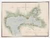
Agno TI bis Porto Ceresio (Italien): Westlicher Teil des Luganersees; Grundriss
Mit Legende.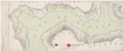
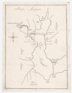
Strittige Grenze zwischen der Schweiz und dem Herzogtum Mailand beim Luganersee; Grundriss
1 : 8000 Mit 2 Siegeln. Portigliotti, Gaudenzo, Ingenieur; Caresana, Giuseppe, Ingenieur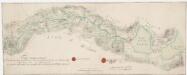
Strittige Grenze zwischen der Schweiz und dem Herzogtum Mailand bei Monteggio, Castel Rotto, Caslano, Cremenaga, Viconago und Lavena; Grundriss
1 : 8000 Mit 2 Siegeln. Portigliotti, Gaudenzo, Ingenieur; Caresana, Giuseppe, Ingenieur
Strittige Grenze zwischen der Schweiz und dem Herzogtum Mailand bei Brusino, Arsizio, Merete, Arzo, Besazio, Porto, Besano, Saltrio und Clivio; Grundriss
1 : 8000 Mit Legende und 2 Siegeln. Portigliotti, Gaudenzo, Ingenieur; Caresana, Giuseppe, Ingenieur
Lugano e dintorni
1 : 25000 Annotatie: Riporto 1897; Annotatie geografische gegevens: Met schaalstok: meter Ufficio topogr. federale, Bern [Bern : Ufficio topogr. federale] / (Berna : Fratelli Kümmerly)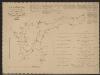
Carta delle profondità del Ceresio o lago di Lugano
1 : 40000 Lavizzari, Luigi [Tip. e Lit. Cantonale]
Pianta della città di Lugano e comuni limitrofi
1 : 5000 Gabriele Chiattone
Bellinzona TI bis Lugano TI: Strasse von Bellinzona nach Lugano sowie von Lugano nach Ponte Tresa und Fornasette; Grundriss
Mit Legende. Fossati, Giuseppe
Die schweizerischen Landvogteyen Lauis und Mendris nebst den Grentzen von Bellenz, Luggaris und mayländischen Gebiet
1 Karte : Kupferdruck ; 46 x 37 cm Finsler; Clausner s.n.
[Comer See und Umgebung]
1 : 256000 Alpy italské (pohoří)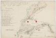
Strittige Grenze zwischen der Schweiz und dem Herzogtum Mailand bei Novazzano, Genestrerio, Stabio, Ligornetto, Bizzarone, Rodero, Ligurno und Clivio; Grundriss
1 : 8000 Mit Legende und 2 Siegeln. Portigliotti, Gaudenzo, Ingenieur; Caresana, Giuseppe, Ingenieur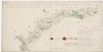
Strittige Grenze zwischen der Schweiz und dem Herzogtum Mailand bei Astano, Sessa, Monteggio, Dumenzo und Luvino; Grundriss
1 : 8000 Mit Legende und 2 Siegeln. Portigliotti, Gaudenzo, Ingenieur; Caresana, Giuseppe, Ingenieur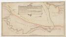
Grenze zwischen der Schweiz und dem Herzogtum Mailand bei Stabio und Clivio; Grundriss
1 : 6000 Mit Legende.
Generalkarte der Gotthardbahn
1 : 100000 Südblatt im Verlag von Orell Füssli & Co.
Gotthardbahn: Airolo - Chiasso
1 : 25000 [s.n.]
<<Die>> schweizerischen Landvogteyen Lauis und Mendris nebst den Grentzen von Bellenz, Luggaris und mayländischen Gebiet
1 : 90000 1 Karte dessta di G. Conr. Finsler ; gravé par [Jakob Joseph] Clausner [Ludwig von Meiss], [Erscheinungsort nicht ermittelbar]
Parte alpeste dello stato di Milano
Mollova mapová sbírka
Topographische Karte der Schweiz
1 : 100000 25 Karten vermessen und hrsg. auf Befehl der Eidgenössischen Behörden ; aufgenommen unter der Aufsicht des Generals G.H. Dufour Eidg. Topographisches Bureau, [Genève], [später: Bern]
Blatt XXIV: Lugano, Como, uit: Topographische Karte der Schweiz / vermessen und hrsg. ... unter Aufsicht des Generals G.H. Dufour
1 : 100000 Annotatie: Met plaatsnamenregister (bl. V), bladwijzer (bl. XXI) en hoogteregister (bl. XXV); Voor aanwezige bladen zie overzichtsblad Dufour, G. H. [Bern : Eidg. Topogr. Bureau]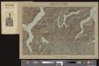
Lugano
1 Vogelschaukarte Orell Füssli, Zürich
Taschen-Atlas der Schweiz
1 Atlas (25 S., 20 Taf.) gezeichnet und gestochen von Emil Wagner = Atlas de poche de la Suisse : 26 cartes en couleurs / dessinées et gravées par Émile Wagner Eggimann, Genf
Stehende Gewässer
Atlas der Hydrographie Berghaus, Hermann Justus Perthes
Der Canton Ticino
1 : 22200 Ticino (Švýcarsko) Keller, H. Ghiringelli, Paolo
Nuova carta topografica dei tre laghi Maggiore, di Lugano e di Como
1 : 180000 Como, jezero (Itálie) Ostinelli, Carlo Antonio C. A. Ostinelli
<<Der>> Canton Ticino
1 : 350000 1 Karte gezeichnet v. H. Keller nach Paolo Ghiringelli ; gest. von J.J. Scheurmann [Orell Füssli & Comp.], [Zürich]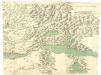
Carta dello Stato di Milano e Piemonte
Mollova mapová sbírka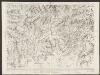
Majeure partie des cantons de Bellinzona et de Lugano et les frontières de la République Italienne
1 : 108000 Weiss, Johann Heinrich ; Guérin, Christophe ; Meyer, Johann Rudolf J. R. Meyer
Oberitalienischen Seen und ihr Excursionsgebiet
1 : 150000 Becker, Fridolin Alfred Arnold