Maps of Como

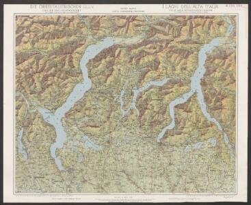
Oberitalienischen Seen und ihr Excursionsgebiet
1 : 150000 Becker, Fridolin Alfred Arnold
<<Die>> Oberitalienischen Seen und ihr Excursionsgebiet
1 : 150000 1 Karte von F. Becker ; Stich der topogr. Anstalt J. Schlumpf, Winterthur Alfred Arnold, Lugano
Nuova carta topografica dei tre laghi Maggiore, di Lugano e di Como
1 : 180000 Como, jezero (Itálie) Ostinelli, Carlo Antonio C. A. Ostinelli
Parte Alpestre dello Stato di Milano
1 : 340000 Mollova mapová sbírka Valk, Gerhard Schenk, Peter I
Stehende Gewässer
Atlas der Hydrographie Berghaus, Hermann Justus Perthes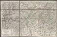
Viaggio ai tre laghi
1 : 188000 Stucchi
Carta di viaggio da Milano ai tre laghi Maggiore di Lugano e di Como e nelle loro vicinanze
1 : 170000 Como, jezero (Itálie)
Atlas Suisse
1 : 120000 16 Karten levé et dessiné par J.H. Weiss [et Joachim Eugen Müller] aux frais de J.R. Meyer à Aarau dans les années 1786 à 1802 ; gravée [sic] par [Christophe] Guérin, [Matthias Gottfried] Eichler et [Johann Jakob] Scheurmann [Johann Rudolf Meyer], Aarau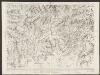
Majeure partie des cantons de Bellinzona et de Lugano et les frontières de la République Italienne
1 : 108000 Weiss, Johann Heinrich ; Guérin, Christophe ; Meyer, Johann Rudolf J. R. Meyer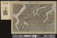
Lugano
1 Vogelschaukarte Orell Füssli, Zürich

Carta del Cantone di Ticino
1 : 250000 Keller, Heinrich ; Hardmeier, C. ; Grimminger, Adolf Enrico Füssli & Co.
Canton Ticino
1 : 350000 Keller, Heinrich ; Scheuermann, Johann Jakob Orell, Füssli & Cp.
Blatt XXIV: Lugano, Como, uit: Topographische Karte der Schweiz / vermessen und hrsg. ... unter Aufsicht des Generals G.H. Dufour
1 : 100000 Annotatie: Met plaatsnamenregister (bl. V), bladwijzer (bl. XXI) en hoogteregister (bl. XXV); Voor aanwezige bladen zie overzichtsblad Dufour, G. H. [Bern : Eidg. Topogr. Bureau]
Topographische Karte der Schweiz
1 : 100000 25 Karten vermessen und hrsg. auf Befehl der Eidgenössischen Behörden ; aufgenommen unter der Aufsicht des Generals G.H. Dufour Eidg. Topographisches Bureau, [Genève], [später: Bern]
<<Die>> schweizerischen Landvogteyen Lauis und Mendris nebst den Grentzen von Bellenz, Luggaris und mayländischen Gebiet
1 : 90000 1 Karte dessta di G. Conr. Finsler ; gravé par [Jakob Joseph] Clausner [Ludwig von Meiss], [Erscheinungsort nicht ermittelbar]
Generalkarte der Gotthardbahn
1 : 100000 Südblatt im Verlag von Orell Füssli & Co.
Parte alpeste dello stato di Milano
Mollova mapová sbírka
[Comer See und Umgebung]
1 : 256000 Alpy italské (pohoří)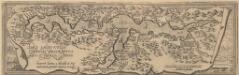
Larii Lacus Culgo Comensis Descirptio [Karte], in: Theatrum orbis terrarum, S. 309.
1 Karte aus Atlas Ortelius, Abraham Vrients, Jan Baptista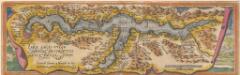
Larii Lacus Culgo Comensis Descirptio [Karte], in: Theatrum orbis terrarum, S. 214.
1 Karte aus Atlas Ortelius, Abraham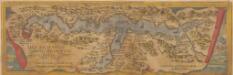
Larii Lacus Vulgo Comensis Descriptio [Karte], in: Theatrum orbis terrarum, S. 85.
1 Karte aus Atlas Ortelius, Abraham
[Lago Maggiore und Umgebung]
1 : 250000 Alpy italské (pohoří) Wagner & Debes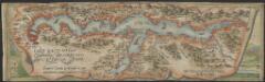
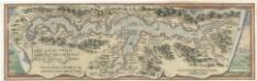
Larii Lacus vulgo Comensis descriptio : excurrit Larius a Meridie in Septentrionem, pronior tamen in Oriente
1 : 150000 auct. Paulo Jovio [S.l.] : [s.n.]
<<Der>> Canton Ticino
1 : 350000 1 Karte gezeichnet v. H. Keller nach Paolo Ghiringelli ; gest. von J.J. Scheurmann [Orell Füssli & Comp.], [Zürich]
Taschen-Atlas der Schweiz
1 Atlas (25 S., 20 Taf.) gezeichnet und gestochen von Emil Wagner = Atlas de poche de la Suisse : 26 cartes en couleurs / dessinées et gravées par Émile Wagner Eggimann, Genf
Der Canton Ticino
1 : 22200 Ticino (Švýcarsko) Keller, H. Ghiringelli, Paolo
Gotthardbahn: Airolo - Chiasso
1 : 25000 [s.n.]
Carte delle prealpi di Lecco
1 : 100000 Grassi