Maps of Zofingen

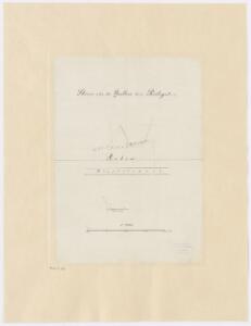
Unterstrass: Wasserquellen beim Rösli-Gut; Grundriss
1 : 1000
Situationsplan von Oftringen u. Umgebung im Cant. Aargau
1 : 25000 J. Wurster u. Comp.
Situationsplan von Oftringen u. Umgebung im Cant. Aargau
1 : 25000 1 Karte bearbeitet nach der aarg. Karte von O. Zschokke J. Wurster u. Comp., Winterthur
Topographische Karte des Kantons Luzern
1 : 25000 Blatt 1 H. Müllhaupt u. Sohn H. Müllhaupt u. Sohn
Topographische Karte des eidgenössischen Kantons Aargau im Auftrag der Staatsbehörden (Michaelis-Karte): Blatt 1
1 : 25000 Mit Titel, Erklärung der Zeichen und Nebenkarte mit Übersicht der 11 Bezirke des Freistaates. Mit zwei Sammelprofilen. Michaelis, Ernst Heinrich (1794-1873), Ingenieurhauptmann und Kartograf, von Preussen Kupferstich: Delsol, Théodore (1819-1870), von Frankreich Schrift: Hacq, J. M.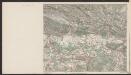
Führer und Exkursions-Karte für Solothurn und Umgebung
1 : 100000 1:100 000 Verkehrs- und Verschönerungs-Verein Solothurn Verkehrs- und Verschönerungs-Verein Solothurn
Topographische Karte des eidgenössischen Kantons Aargau
1 : 50000 1 Karte auf 4 Bl. im Auftrage der Staatsbehörden nach dem Massstabe von 1:25 000 in den Jahren 1837 bis 1843 aufgenommen und 1844/45 in den Massstab von 1:50 000 übertragen durch Ernst Heinrich Michaelis ; den Kupferstich besorgte 1845 bis 1848 Th. Delsol ; die Schrift J.M. Hacq Rud. Foppert, Zürich
Wandkarte von Basel und Umgebung
1 : 50000 1 Karte in 4 Teilen bearbeitet von J. Randegger Carl Detloff, Basel
Atlas novus Reipublicae Helveticae
1 Atlas ([40] Bl., 97 S.) bey Orell, Gessner und Compagnie, Zürich
Canton Basel sive Pagus Helvetiae Basileensis cum confinibus recenter
1 : 70000 Mollova mapová sbírka Walser, Gabriel Homann, Johann Baptista - dědici

Karte vom Canton Basel
1 : 50000 1 Karte auf 4 Bl. entworfen von Andreas Kündig im Verlag von C. Detloff in Basel ; geologisch aufgenommen u. dargestellt von Albr. Müller in Basel 1862 Wurster & Cie., Winterthur
Canton Solothurn Sive Pagus Helvetiae Solodurensis cum Confinibus recenter delineatus
1 : 110000 Mollova mapová sbírka Walser, Gabriel Homann, Johann Baptista - dědici

Karte der Kantone Baselland und Baselstadt
1 : 100000 1 Karte von J.S. Gerster ; auf Anordnung der h. Erziehungsdirection von Baselland ; Zeichnung, Stich u. Druck von Wurster, Randegger & Cie. in Winterthur Wurster, Randegger & Cie., Winterthur
Der Canton Basel mit den angränzenden Bezirken
1 : 79000 Basilej-oblast (Švýcarsko) Diewald, Johann Nepomuk Bruckner bey Homanns Erben
Canton Solothurn sive pagus Helvetiae Solodurensis cum confinibus
1 : 134500 Solothurn (Švýcarsko : kanton) Walser, Gabriel edentibus Homann. Heredib[us]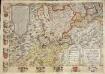
Inclitae Bernatum urbis, cum omni ditionis suae agro et provinciis delineatio chorographica, 13/14
2 Blätter : Adelbert Saueracher
Canton Solothurn sive pagus Helvetiae Solodurensis cum confinibus
1 Karte : Kupferdruck ; 46 x 55 cm Walser Homann. Heredibus
Canton Solothurn sive pagus Helvetiae Solodurensis cum confinibus
1 Karte : Kupferdruck ; 46 x 55 cm Walser Homann. Heredibus
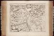
Canton Lucern sive illustris helvetiorum respublica Lucernensis cum subditis suis et confinibus
1 Karte : Kupferdruck ; 46 x 55 cm Walser edentibus Homannianis Heredibus
Canton Lucern sive illustris helvetiorum respublica Lucernensis cum subditis suis et confinibus
1 Karte : Kupferdruck ; 46 x 55 cm Walser edentibus Homannianis Heredibus
Das undere Argaw mit seinen anstossenden Gränzen
1 Manuskriptkarte : 43 x 74 cm Bodmer s.n.
Canton Solothurn sive pagus Helvetiae Solodurensis cum confinibus
1 Karte : Kupferdruck ; 23 x 25 cm Walser Homännische Erben
Nova descriptio ditionis Tigurinae regionumque finitimarum
1 : 95000 1 Karte auf 6 Bl. Joh. Conradus Gygerus, P. delineavit ; Joh. Georgius Gygerus, F. in aes incidi ; curavit per Johannem Meyerum Ao. 1685
Carte von dem Canton Aargau
1 : 120000 Scheuermann, Johann Jakob Scheurmann
Geographica Provinciarum Sveviae Descriptio =
Mollova mapová sbírka Hurter, Johann Christoph Bodenehr, Gabriel
Archäologische Karte des Kantons Solothurn
1 : 100000 Heierli, Jakob Petri
Canton inter catholicos primaria, sive illustris Helvetiorum respublica Lucernensis cum subditis suis et confinibus
1 Karte : Kupferdruck ; 48 x 56 cm Walser; Seutter Albrecht Carl Seutter