Maps of Lucerne


Canton Lucern sive illustris helvetiorum respublica Lucernensis cum subditis suis et confinibus
1 Karte : Kupferdruck ; 46 x 55 cm Walser edentibus Homannianis Heredibus
Canton Lucern sive illustris helvetiorum respublica Lucernensis cum subditis suis et confinibus
1 Karte : Kupferdruck ; 46 x 55 cm Walser edentibus Homannianis Heredibus
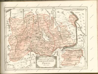
Canton Inter Catholicos primaria, Sive Illustris Helvetiorum Respublica Lucernensis cum Subditis suis et confinibus recenter et accurate delineata
1 : 100000 Mollova mapová sbírka Walser, Gabriel Seutter, Albrecht Carl
Canton Lucern sive Illustris Helvetiorum Respublica Lucernensis cum Subditis suis cum Subditis suis et Confinibus denuo correcta
1 : 100000 Mollova mapová sbírka Walser, Gabriel Homann, Johann Baptista - dědici
Canton Lucern sive Illustris Helvetiorum Respublica Lucernensis cum Subditis suis cum Subditis suis et Confinibus denuo correcta
1 : 100000 Mollova mapová sbírka Walser, Gabriel Homann, Johann Baptista - dědici
Canton inter catholicos primaria, sive illustris Helvetiorum respublica Lucernensis cum subditis suis et confinibus
1 Karte : Kupferdruck ; 48 x 56 cm Walser; Seutter Albrecht Carl Seutter
Karte vom Kanton Luzern
1 : 150000 1 Karte entworfen mit Benutzung ungedruckter Materialien u. Zeichnungen nach der Natur [von] F. Dula ; gez. von H. Keller, Sohn ; hrsg. von H. Keller [Vater] Keller, Zürich
Canton Lucern sive illustris helvetiorum respublica Lucernensis
1 Karte : Kupferdruck ; 23 x 25 cm Walser Homännische Erben
Karte des Kantons Luzern
1 : 200000 Müllhaupt, Fritz Schiffmann
Nova descriptio ditionis Tigurinae regionumque finitimarum
1 : 95000 1 Karte auf 6 Bl. Joh. Conradus Gygerus, P. delineavit ; Joh. Georgius Gygerus, F. in aes incidi ; curavit per Johannem Meyerum Ao. 1685
Nova descriptio ditionis Tigurinae regionumque finitimarum
1 : 95000 1 Karte auf 6 Bl. Joh. Conradus Gygerus, P. delineavit ; Joh. Georgius Gygerus, F. in aes incidi ; curavit per Johannem Meyerum Ao. 1685
Uebersichtskarte der Eisenbahn von Huttwil nach Wohlhusen
1 : 100000 Kümmerly
Karte des Kantons Luzern
1 : 50000 1 Karte in 6 Blättern von J.S. Gerster J.J. Hofer, Zürich
Topographische Karte des eidgenössischen Kantons Aargau
1 : 50000 1 Karte auf 4 Bl. im Auftrage der Staatsbehörden nach dem Massstabe von 1:25 000 in den Jahren 1837 bis 1843 aufgenommen und 1844/45 in den Massstab von 1:50 000 übertragen durch Ernst Heinrich Michaelis ; den Kupferstich besorgte 1845 bis 1848 Th. Delsol ; die Schrift J.M. Hacq Rud. Foppert, Zürich
Topographische Karte des eidgenössischen Kantons Aargau im Auftrag der Staatsbehörden (Michaelis-Karte): Blatt 2
1 : 25000 Mit Sammelprofil. Michaelis, Ernst Heinrich (1794-1873), Ingenieurhauptmann und Kartograf, von Preussen Kupferstich: Delsol, Théodore (1819-1870), von Frankreich Schrift: Hacq, J. M.
Topographische Karte des Kantons Luzern
1 : 25000 Blatt 3 H. Müllhaupt u. Sohn H. Müllhaupt u. Sohn
Topographische Karte des Kantons Luzern
1 : 25000 Blatt 2 H. Müllhaupt u. Sohn H. Müllhaupt u. Sohn
Topographische Karte des Kantons Luzern
1 : 25000 Blatt 1 H. Müllhaupt u. Sohn H. Müllhaupt u. Sohn
Hans Konrad Gyger's Züricher-Cantons-Carte 1667
1 : 32000 1 Karte in 56 Teilen Hans Konrad Gyger
Hans Konrad Gyger's Züricher-Cantons-Carte 1667
1 : 32000 1 Karte in 56 Teilen Hans Konrad Gyger
Hans Konrad Gyger's Züricher-Cantons-Carte 1667
1 : 32000 1 Karte in 56 Teilen Hans Konrad Gyger
Hans Konrad Gyger's Züricher-Cantons-Carte 1667
1 : 32000 1 Karte in 56 Teilen Hans Konrad Gyger
Karte von Luzern und Umgebung
1 : 25000 Luzern (Švýcarsko) Verschönerungsverein der Stadt Luzern
Kanton Zürich: Staats-, Gemeinde- und Genossenschaftswaldungen: Blatt 13: Gegend bei Kappel am Albis, Maschwanden, Mettmenstetten und Aeugst am Albis; Situationsplan
1 : 25000 Auf Ausgangskarten angebrachte farbige Eintragungen und Einzeichnungen. Ohne Erstellungsdatumsangabe. Ausgangskarten: Blätter 173 (Merenschwand), 176 (Mettmenstetten), 187 (Hochdorf) und 190 (Cham) des Topographischen Atlasses der Schweiz (Siegfried-Karte). Hartmann, Karl, Forstadjunkt im Zürcher Oberforstamt, von Aarau, in Unterstrass
Hans Konrad Gyger's Züricher-Cantons-Carte
1 : 32000 Blatt 55 Gyger, Hans Conrad ; Zeller-Werdmüller, Heinrich Hofer & Burger
Grosse Landtafel des Zürcher Gebiets: Blatt 55: Ermensee und Umgebung
Möglicherweise: Wagner, Johann (1675-1714)
Topographische Karte des Kantons Luzern
1 : 25000 Blatt 5 H. Müllhaupt u. Sohn H. Müllhaupt u. Sohn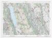
Landeskarte der Schweiz 1 : 25000: Den Kanton Zürich betreffende Blätter: Blatt 1110: Hitzkirch LU
1 : 25000 Erstausgabe 1953; Nachführungen 1963, 1970, 1976, 1982, 1988, 1994, 2000. Bundesamt für Landestopografie swisstopo, in Köniz-Wabern