Maps of Usingen

Meßtischblatt 3276 : Usingen, 1877
1 : 250000 Usingen. - Aufn. 1868. - 1:25000. - [Berlin]: Kgl. Min. f. Handel, 1877. - 1 Kt.
Die Umgebung von Homburg = The environs of Homburg
1 : 75000 gez[eichnet] von Fritz Schick Bad Homburg : Louis Schick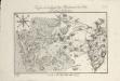
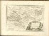
Karte von der Gegend bey Homburg vor der Höhe und dasigen Gebürgen
1 : 90000 Coentgen, Heinrich Hugo
[26] Sect. Wetzlar, uit: Geologische Karte der Rheinprovinz und der Provinz Westphalen / ausgeführt durch H. von Dechen
1 : 80000 titelvariant: Dechen's geologische Karte vom Rheinland und Westphalen; Annotatie: Titel op bladoverzicht; Incompleet Heinrich von Dechen Berlin : Schropp
Le Flambeau de la Guerre Allumee au Rhin
Mollova mapová sbírka Delisle, Guillaume Schenk, Peter II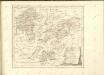
Strategische Situation am: 26. Juni, 4. Juli (Abends), 10. Juli (9 Uhr Morgens), 14. Juli Machmittags nach dem Gefecht von Aschaffenburg, 21. Juli, 26. Juli (Morges)
Hesensko (Německo)
139. Frankfurt a. M., uit: Topographische Uebersichtskarte des Deutschen Reiches / herausgegeben v. d. Kartogr. Abt. d. Königl. Preuß. Landesaufnahme
1 : 200000 titelvariant: Topogr. Übersichtskarte des Deutschen Reiches; Annotatie: Titel boven bladen ook: Topogr. Übersichtskarte des Deutschen Reiches; Annotatie geografische gegevens: Op elk blad twee maatstokken: 10 Kilometer = 5,5 cm; 1 geogr. Meile = 3,6 cm; Legenda onder op elk blad Königlich Preußische Landesaufnahme. Kartographische Abtheilung [S.l : Königlich Preußische Landesaufnahme, Kartographische Abtheilung]
Wetteravia
1 : 75000 Mollova mapová sbírka Merian, Matthaeus Merian, Matthäus - dědici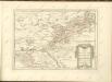

Les Environs De La Lahne depuis Marbvrg iusqu' à Ems avec les pais adiacents
1 : 200000
Nassovia Principatus
1 : 170000 Mollova mapová sbírka Stetter, Johann Jakob Schenk, Peter II
Wetteravia
1 : 210000 Mollova mapová sbírka Valk, Gerhard Schenk, Peter I
Pars Vederoviae plvrimas ditiones princ. et com. Nassovicor. imprimis verô regionem Schwalbacensem acidulis claram exhibens accurate distincta
Hesensko (Německo) Homann, Johann Baptist J. B. Homann
Wetteravia
1 : 170000 Mollova mapová sbírka Seutter, Matthäus Seutter, Matthäus
Wetteravia
1 : 170000 Mollova mapová sbírka Seutter, Matthäus Seutter, Matthäus
Pars Vederoviae Plurimas Ditiones Princ. et Com. Nassovicor. imprimis verô Regionem Schwalbacensem Acidulis claram
1 : 170000 Mollova mapová sbírka Homann, Johann Baptist Homann, Johann Baptista
Wetteraviae
1 : 170000 Mollova mapová sbírka Stetter, Johann Jakob Stridbeck, Johann Baur, Johann
Wetteravia die Wetteraw
1 : 210000 Mollova mapová sbírka Pitt, Moses
Mappa geographica exhibens principatum Nassoviae
1 : 172000 Nasavsko Lotter, Tobias Conrad Lotter, Georg F. sumptibus et curis Tobiae Conradi Lotter
Hassiae Svperioris et Wetterav. Partis Delineatio
1 : 170000 Mollova mapová sbírka Bronner, Christian Maximilian Homann, Johann Baptista - dědici
Nassovia principatus, cum omnibus ei pertinentibus comitatibus dominiiis, ac praefecturis, ut et confiniis intrá Lahnum, Rhenum et Moenum flumina
1 : 1500000 ad situm verum exacte delineatus â Joh. Jac. Stetter [...] excudit Nic. Visscheri vidua Amstelodami : nunc apud Petrum Schenk Iunior
Wetteravia cum omnibus inclusis principatibus, comitatibus, dominiis et praefecturis, et confinibus provinciis accuratissime designata et juxta limites determinata
1 : 176000 Wetterau (Německo) Seutter, Matthäus sumtibus Matthaei Seutteri
S. R. Imp. comitatus Hanau
1 : 190000 Büdingen (Německo) Zollmann, Friedrich Homann, Johann Baptist J. B. Homann
S. R. Imp. comitatus Hanau
1 : 190000 Büdingen (Německo) Zollmann, Friedrich Homann, Johann Baptist J. B. Homann
WETTERAVIA. | Vulgo | Die Wetteraw
[Amsterdam : Joan Blaeu]
S. R. Imp. Comitatus Hanau proprie sic dictus, cum singulis suis Praefecturis, ut et Comitatus Solms Budingen et Nidda cumreliqua Wetteravia et vicinis Regionibus
1 : 230000 Mollova mapová sbírka Zollmann, Friedrich Homann, Johann Baptista - dědici
Wetteravia die Wetteraw.
1 : 210000 Walther, Johann Georg Walther
Section Weilburg, uit: Charte von dem Grossherzogtum Hessen und dem Herzogtum Nassau / trigonometrisch aufgenommen und hrsg. von C.L.P. Eckhardt
1 : 200000 titelvariant: Karte von Hessen und Nassau Eckhardt, C. L. P Darmstadt : Joh. Wilh. Heyer