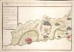
Maps of Wetteraukreis

Wetteravia
1 : 75000 Mollova mapová sbírka Merian, Matthaeus Merian, Matthäus - dědici
Wetteravia die Wetteraw
1 : 210000 Mollova mapová sbírka Pitt, Moses
Wetteraviae
1 : 170000 Mollova mapová sbírka Stetter, Johann Jakob Stridbeck, Johann Baur, Johann
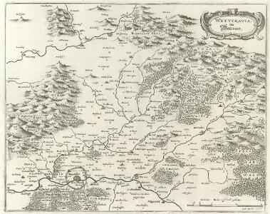
WETTERAVIA. | Vulgo | Die Wetteraw
[Amsterdam : Joan Blaeu]
Wetteravia die Wetteraw.
1 : 210000 Walther, Johann Georg Walther
Wetteravia. die Wetteraw. [Karte], in: Novus atlas absolutissimus, Bd. 2, S. 186.
1 Karte aus Atlas Janssonius Offizin
Wetteraviae Hanc Cum Confiniis Delineationem Serenissimo Principi Ac Domino, D[omi]no Ernesto Ludovico, Hassiae Landgravio, Principi Hersfeldiae, Comiti In Cattimeliboco, Decia, Ziegenhaina, Nidda, Schaumburg, Isemburgo Et Budinga, Etc. Domino suo clementißimo humilimè offert Ioh. Iacob Stetter, I. U. L.
Stetter, Johann Jakob; Stridbeck, Johann Hutter
Wetteravia cum omnibus inclusis principatibus, comitatibus, dominiis et praefecturis, et confinibus provinciis accuratissime designata et juxta limites determinata
1 : 176000 Wetterau (Německo) Seutter, Matthäus sumtibus Matthaei Seutteri
Hassiae Svperioris et Wetterav. Partis Delineatio
1 : 170000 Mollova mapová sbírka Bronner, Christian Maximilian Homann, Johann Baptista - dědici
S. R. Imp. Comitatus Hanau proprie sic dictus, cum singulis suis Praefecturis, ut et Comitatus Solms Budingen et Nidda cumreliqua Wetteravia et vicinis Regionibus
1 : 230000 Mollova mapová sbírka Zollmann, Friedrich Homann, Johann Baptista - dědici
Wetteravia
1 : 210000 Mollova mapová sbírka Valk, Gerhard Schenk, Peter I
S. R. Imp. comitatus Hanau
1 : 190000 Büdingen (Německo) Zollmann, Friedrich Homann, Johann Baptist J. B. Homann
S. R. Imp. comitatus Hanau
1 : 190000 Büdingen (Německo) Zollmann, Friedrich Homann, Johann Baptist J. B. Homann
Wetteravia
1 : 170000 Mollova mapová sbírka Seutter, Matthäus Seutter, Matthäus
Wetteravia
1 : 170000 Mollova mapová sbírka Seutter, Matthäus Seutter, Matthäus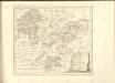

139. Frankfurt a. M., uit: Topographische Uebersichtskarte des Deutschen Reiches / herausgegeben v. d. Kartogr. Abt. d. Königl. Preuß. Landesaufnahme
1 : 200000 titelvariant: Topogr. Übersichtskarte des Deutschen Reiches; Annotatie: Titel boven bladen ook: Topogr. Übersichtskarte des Deutschen Reiches; Annotatie geografische gegevens: Op elk blad twee maatstokken: 10 Kilometer = 5,5 cm; 1 geogr. Meile = 3,6 cm; Legenda onder op elk blad Königlich Preußische Landesaufnahme. Kartographische Abtheilung [S.l : Königlich Preußische Landesaufnahme, Kartographische Abtheilung]
Le Flambeau de la Guerre Allumee au Rhin
Mollova mapová sbírka Delisle, Guillaume Schenk, Peter II
Section Giessen, uit: Charte von dem Grossherzogtum Hessen und dem Herzogtum Nassau / trigonometrisch aufgenommen und hrsg. von C.L.P. Eckhardt
1 : 200000 titelvariant: Karte von Hessen und Nassau Eckhardt, C. L. P Darmstadt : Joh. Wilh. Heyer
162 Giessen, uit: Topographische Special-Karte von Deutschland (von Central-Europa) / begründet von D.G. Reymann ; [entworfen und gezeichn. von Heinrich Berghaus... [et al.]]
1 : 200000 Annotatie: Lit.: Daniel Gottlob Reymann und die "Topographische Special-Karte von Deutschland" / von Wolfgang Scharfe, in: Kartographische Nachrichten, 39 (1989), Heft I, p. 1-10; Handgeschreven titel: Reymann's Deutschland : 24 Sectionen: Jena, Penig, Dresden, Zittau, Hirschberg, Breslau, Brieg, Andernach, Coblenz, Giessen, Fulda, Schleusingen, Plauen, Zwickau, Teplitz, Jung Bunzlau, Hohenelbe, Glatz, Neisse, Simmern, Prag, Luxemburg, Birkenfeld; Aanwezig: 23 bladen Reymann, Daniel Gottlob; Berghaus, Heinrich [Berlin : 2. Departement des Kriegsministeriums, Bureau für Plan- und Kartenzeichnung]
[26] Sect. Wetzlar, uit: Geologische Karte der Rheinprovinz und der Provinz Westphalen / ausgeführt durch H. von Dechen
1 : 80000 titelvariant: Dechen's geologische Karte vom Rheinland und Westphalen; Annotatie: Titel op bladoverzicht; Incompleet Heinrich von Dechen Berlin : Schropp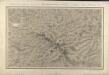
Section Ullrichstein
Eckhardt, Christian Leonhard Philipp; Haas, Johann Heinrich; Meister, G.; Stoltz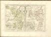
Les Environs de Giesen et de Wetzlar

Die Umgebung von Homburg = The environs of Homburg
1 : 75000 gez[eichnet] von Fritz Schick Bad Homburg : Louis Schick
Le Flambeau de la Guerre Allumee au Rhin
Mollova mapová sbírka Delisle, Guillaume Schenk, Peter II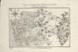
Karte von der Gegend bey Homburg vor der Höhe und dasigen Gebürgen
1 : 90000 Coentgen, Heinrich Hugo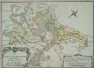
Plan des Hoch. Fvrst-Hess[isch] Darmstattischen Oberamts Giesen
1 : 60000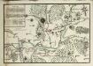
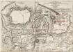
Plan Von der Stellung der Alliirten Armée unter Commando des Herzogs Ferdinand von Braunschweig, und des Französischen Generals Herzogs von Broglio ohnfern Giesen, vom 18. Septr. 1759. bis den 4. Jan. 1760
Ludwig Wilhelm (Hessen-Homburg, Landgraf)