Maps of Maryland

A Chart of the Chesapeake And Delaware Bays
1 : 354816 Lucas, Fielding Jr.
A map of Virginia and Maryland
1 : 1150000 Speed, John Basset, Thomas
A Chart of the Chesapeake And Delaware Bays.
1 : 354816 Lucas, Fielding Jr.
Strategic War Points of the United States no.3: the country round the Chesapeake and the Potomac to Washington
Strategic War points of the United States no.3: the country round the Chesapeake and the Potomac to Washington J. Wyld
Composite: New Map Of The Peninsula Embracing Delaware And The Eastern Shores Of Maryland And Virginia
1 : 346480 MacCormac, Walter S.
Map of part of Virginia, Maryland and Delaware from the best authorities
1 : 400000 Heyne, Charles E. & G.W. Blunt (Firm)
Virginia & Maryland.
1 : 1150000 Bowen, Emanuel
Delaware and Mary-Land / By David H. Burr, New-York; engd. & printed by Illman & Pilbrow.
from Parts David H. Burr; Illman & Pilbrow,
Maryland.
1 : 1774080 Scott, Joseph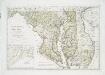
Maryland und Delaware / entworfen von D.F. Sotzmann ; W. Sander, sculp.
from Charts and maps
Maryland and Delaware.; The cerographic atlas of the United States. By Sidney E. Morse, A.M., and Samuel Breese, A.M.
from Supplement to the New York observer. Morse, Sidney E. (Sidney Edwards); Breese, Samuel,
Maryland und Delaware
1 : 500000 Sotzmann, D. F Bey Carl Ernst Bohn
States of Maryland and Delaware.
1 : 800000 Winterbotham, W.
A map of Virginia : formed from actual surveys and the latest as well as the most accurate observations / by James Madison ; drawn by Wm. Davis ; with extensive additions and corrections to the year 1818.
from Charts and maps
The states of Maryland and Delaware, from the latest surveys
1 : 800000 Wayland, Reid & Smith
Bird's-eye view of the Seat of War
Bird's-eye view of the Seat of War, arranged after the latest Surveys. This Bird’s Eye View of the Seat of War, published by Prang, displays the region around the Chesapeake Bay and Potomac River, showing Washington, D.C., Baltimore, Harper’s Ferry, Richmond, Manassas Junction (Bull Run), Fort Monroe and Norfolk Harbour. The map also details railroad lines. It is possible to see a drawing of the Capitol building where Washington, D.C. is labelled. L. Prang & Co.
Maryland, Delaware.
1 : 1300000 Cram, George Franklin; Davis, Ellis Arthur
Maryland, Delaware and District of Columbia
1 : 900000 Baltimore (Maryland : oblast) National Geographic Society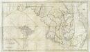
Map of the state of Maryland : laid down from an actual survey of all the principal waters, public roads, and divisions of the counties therein : describing the situation of the cities, towns, villages, houses of worship and other public buildings, furna
from Maryland
Maryland.
1 : 1380000 Tanner, Henry S.
Maryland and Delaware.
Rand McNally and Company
Virginia and Maryland.
1 : 1340000 Moll, Herman, d. 1732
Delaware and Maryland.
1 : 2000000 Colton, G.W.
A map of Virginia : formed from actual surveys, and the latest as well as most accurate observations / by James Madison, D.D., president of Wm. & Mary College. ; drawn by Wm. Davis ; engraved by Fred. Bossler, Richmd.
From Charts and maps
Maryland. Delaware.
1 : 874643 Hammond, C.S.
Maryland.
1 : 1385000 Finley, Anthony
Maryland, Washington D.C., and Delaware.
1 : 697000 Rand McNally and Company
Martenet's Map of Maryland, Atlas Edition.
1 : 950400 Martenet, Simon J.
New railroad map of the states of Maryland, Delaware, & District of Columbia.
1 : 633600 Gray, Frank Arnold


