Maps of Ludwigslust-Land

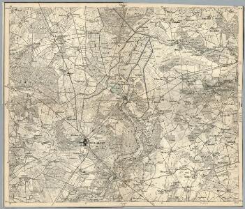
Composite: 181. Ludwigslust. (Germany)
1 : 100000 Reichsamt fur Landesaufnahme
Meßtischblatt 2635 : Neustadt bei Ludwigslust, 1951
1 : 250000 Neustadt bei Ludwigslust. - Bericht. 1904, letzte Nachtr. 1919, Ausgabe 1951. - 1:25000. - [S.l.]: Deutsche Wertpapier-Druckerei VEB, 1951. - 1 Kt.
Meßtischblatt 2634 : Ludwigslust, 1952
1 : 250000 Ludwigslust. - Hrsg. 1881, Ausg. 1911, gedr. 1936. - 1:25000. - [S.l.]: Landesregierung Sachsen-Anhalt, Min. des Innern. Abt. Vermessung, 1952. - 1 Kt.
Meßtischblatt 2535 : Hohewisch, 1924
1 : 250000 Hohewisch. - Hrsg. 1881, bericht. 1904, letzte Nachtr. 1924. - 1:25000. - [Berlin]: Reichsamt für Landesaufnahme, 1924. - 1 Kt.
Meßtischblatt 2534 : Lüblow, 1951
1 : 250000 Lüblow. - Hrsg. 1881, Ausgabe 1904. - 1:25000. - [S.l.]: Landesregierung Sachsen-Anhalt, Anstalt für Kartographie und Kartendruck, 1951. - 1 Kt.
Meßtischblatt 2636 : Karenzin, 1881
1 : 250000 Karenzin. - Aufn. 1879. - 1:25000. - [Berlin]: Reichsamt für Landesaufnahme, 1881. - 1 Kt.
Meßtischblatt 2536 : Spornitz, 1953
1 : 250000 Spornitz. - Hrsg. 1879, letzte Nachtr. 1924. - 1:25000. - [S.l.]: M.D.I., 1953. - 1 Kt.
A colored "Plan von Ludwigslust"
A colored manuscript Plan von Ludwigslust in Germany, showing architectural and engineering works.
181. Ludwigslust. (Germany)
1 : 100000 Reichsamt fur Landesaufnahme
Meßtischblatt 2735 : Grabow a. d. Elde, 1924
1 : 250000 Grabow a. d. Elde. - Hersg. 1881, letzte Nachtr. 1924. - 1:25000. - [Berlin]: Reichsamt für Landesaufnahme, 1924. - 1 Kt.
Meßtischblatt 2734 : Eldena, 1957
1 : 250000 Eldena. - Hrsg. 1881, Ausg. 1919, gedr. [19]37. - 1:25000. - [S.l.]: VD Nord, 1957. - 1 Kt.
Meßtischblatt 2736 : Balow, 1952
1 : 250000 Balow. - Hrsg. 1879, letzte Nachtr. 1924, Ausgabe 1952. - 1:25000. - [S.l.]: Deutsche Wertpapier-Druckerei VEB, 1952. - 1 Kt.
Germany/Central Europe 1:100,000, Schwerin
Germany / Central Europe 1:100,000, Series GSGS 4416. Great Britain. War Office. [London] : Ordnance Survey
59. Ludwigslust, uit: Topographische Uebersichtskarte des Deutschen Reiches / herausgegeben v. d. Kartogr. Abt. d. Königl. Preuß. Landesaufnahme
1 : 200000 titelvariant: Topogr. Übersichtskarte des Deutschen Reiches; Annotatie: Titel boven bladen ook: Topogr. Übersichtskarte des Deutschen Reiches; Annotatie geografische gegevens: Op elk blad twee maatstokken: 10 Kilometer = 5,5 cm; 1 geogr. Meile = 3,6 cm; Legenda onder op elk blad Königlich Preußische Landesaufnahme. Kartographische Abtheilung [S.l : Königlich Preußische Landesaufnahme, Kartographische Abtheilung]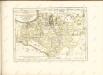

Mappa Ducatus Megalopolitani Nova :
1 : 190000 Mollova mapová sbírka
Schwerin 34, uit: Special-Karte von Mittel-Europa / nach amtlichen Quellen bearbeitet von W. Liebenow
1 : 300000 titelvariant: W. Liebenow's Mittel-Europa; Annotatie: Titel boven de bladen: W. Liebenow's Mittel-Europa Johannes Wilhelm Liebenow 1822-1897 Frankfurt a. M. : Ludwig Ravenstein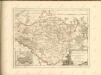

Composite: 212. Lenzen. (Germany)
1 : 100000 Reichsamt fur Landesaufnahme
212. Lenzen. (Germany)
1 : 100000 Reichsamt fur Landesaufnahme
Meßtischblatt 2434 : Sülstorf, 1881
1 : 250000 Sülstorf. - Aufn. 1879. - 1:25000. - [Berlin]: Reichsamt für Landesaufnahme, 1881. - 1 Kt.
Meßtischblatt 2435 : Crivitz, 1935
1 : 250000 Crivitz. - Hrsg. 1881, ber. 1904, einz. Nachtr. 1919. - 1:25000. - [Berlin]: Reichsamt für Landesaufnahme, 1935. - 1 Kt.
MARCHIONATUS | BRANDENBURGICI | PARTES DUÆ, | RUPPIN | Comitatus | & | PRIGNITS | Regiuncula
Auct. Olao Iohannis Gotho, Gustavo Magno Cosm. [Amsterdam : Joan Blaeu]
Ducatus Luneburgicus cum comitatu Dannebergensi
1 : 336000 Lüneburg (Německo) Seutter, Matthäus Matth. Seutter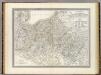
Mecklenburg-Schwerin, Mecklenburg-Strelitz.
1 : 360000 Weiland, C. F. (Carl Ferdinand), d. 1847
Marchia Vetus, Vulgo Alte Marck in March: Brandenburgico. [Karte], in: Novus atlas absolutissimus, Bd. 2, S. 57.
1 Karte aus Atlas Janssonius Offizin

Meklenbvrg Dvcatvs
1 : 520000 Mollova mapová sbírka Lauremberg, Johann Schenk, Peter I
Meklenbvrg Dvcatvs
1 : 520000 Mollova mapová sbírka Lauremberg, Johann Janssonius, Johannes I