Maps of Ludwigslust-Land

181. Ludwigslust. (Germany)
1 : 100000 Reichsamt fur Landesaufnahme
Composite: 181. Ludwigslust. (Germany)
1 : 100000 Reichsamt fur Landesaufnahme
Meßtischblatt 2736 : Balow, 1952
1 : 250000 Balow. - Hrsg. 1879, letzte Nachtr. 1924, Ausgabe 1952. - 1:25000. - [S.l.]: Deutsche Wertpapier-Druckerei VEB, 1952. - 1 Kt.
Meßtischblatt 2735 : Grabow a. d. Elde, 1924
1 : 250000 Grabow a. d. Elde. - Hersg. 1881, letzte Nachtr. 1924. - 1:25000. - [Berlin]: Reichsamt für Landesaufnahme, 1924. - 1 Kt.
Meßtischblatt 2734 : Eldena, 1957
1 : 250000 Eldena. - Hrsg. 1881, Ausg. 1919, gedr. [19]37. - 1:25000. - [S.l.]: VD Nord, 1957. - 1 Kt.
Meßtischblatt 2636 : Karenzin, 1881
1 : 250000 Karenzin. - Aufn. 1879. - 1:25000. - [Berlin]: Reichsamt für Landesaufnahme, 1881. - 1 Kt.
Meßtischblatt 2635 : Neustadt bei Ludwigslust, 1951
1 : 250000 Neustadt bei Ludwigslust. - Bericht. 1904, letzte Nachtr. 1919, Ausgabe 1951. - 1:25000. - [S.l.]: Deutsche Wertpapier-Druckerei VEB, 1951. - 1 Kt.
Meßtischblatt 2634 : Ludwigslust, 1952
1 : 250000 Ludwigslust. - Hrsg. 1881, Ausg. 1911, gedr. 1936. - 1:25000. - [S.l.]: Landesregierung Sachsen-Anhalt, Min. des Innern. Abt. Vermessung, 1952. - 1 Kt.
Meßtischblatt 2536 : Spornitz, 1953
1 : 250000 Spornitz. - Hrsg. 1879, letzte Nachtr. 1924. - 1:25000. - [S.l.]: M.D.I., 1953. - 1 Kt.
Meßtischblatt 2535 : Hohewisch, 1924
1 : 250000 Hohewisch. - Hrsg. 1881, bericht. 1904, letzte Nachtr. 1924. - 1:25000. - [Berlin]: Reichsamt für Landesaufnahme, 1924. - 1 Kt.
Meßtischblatt 2534 : Lüblow, 1951
1 : 250000 Lüblow. - Hrsg. 1881, Ausgabe 1904. - 1:25000. - [S.l.]: Landesregierung Sachsen-Anhalt, Anstalt für Kartographie und Kartendruck, 1951. - 1 Kt.
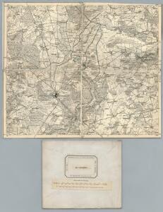
A colored "Plan von Ludwigslust"
A colored manuscript Plan von Ludwigslust in Germany, showing architectural and engineering works.
Meßtischblatt 2737 : Hülsebeck, 1936
1 : 250000 Hülsebeck. - Hrsg. 1881, kl. Nachtr. 1924, gedr. [19]36. - 1:25000. - [Berlin]: Reichsamt für Landesaufnahme, 1936. - 1 Kt.
Meßtischblatt 2637 : Marnitz, 1919
1 : 250000 Marnitz. - Hrsg. 1881 ?. - 1:25000. - [Berlin]: Reichsamt für Landesaufnahme, 1919. - 1 Kt.
Meßtischblatt 2537 : Parchim, 1919
1 : 250000 Parchim. - Hrsg. 1881, letzte Nachtr. 1919. - 1:25000. - [Berlin]: Reichsamt für Landesaufnahme, 1919. - 1 Kt.
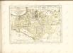
59. Ludwigslust, uit: Topographische Uebersichtskarte des Deutschen Reiches / herausgegeben v. d. Kartogr. Abt. d. Königl. Preuß. Landesaufnahme
1 : 200000 titelvariant: Topogr. Übersichtskarte des Deutschen Reiches; Annotatie: Titel boven bladen ook: Topogr. Übersichtskarte des Deutschen Reiches; Annotatie geografische gegevens: Op elk blad twee maatstokken: 10 Kilometer = 5,5 cm; 1 geogr. Meile = 3,6 cm; Legenda onder op elk blad Königlich Preußische Landesaufnahme. Kartographische Abtheilung [S.l : Königlich Preußische Landesaufnahme, Kartographische Abtheilung]
Germany/Central Europe 1:100,000, Schwerin
Germany / Central Europe 1:100,000, Series GSGS 4416. Great Britain. War Office. [London] : Ordnance Survey
Composite: 212. Lenzen. (Germany)
1 : 100000 Reichsamt fur Landesaufnahme
212. Lenzen. (Germany)
1 : 100000 Reichsamt fur Landesaufnahme
Composite: 182. Parchim. (Germany)
1 : 100000 Reichsamt fur Landesaufnahme
182. Parchim. (Germany)
1 : 100000 Reichsamt fur Landesaufnahme
Meßtischblatt 2434 : Sülstorf, 1881
1 : 250000 Sülstorf. - Aufn. 1879. - 1:25000. - [Berlin]: Reichsamt für Landesaufnahme, 1881. - 1 Kt.
Meßtischblatt 2435 : Crivitz, 1935
1 : 250000 Crivitz. - Hrsg. 1881, ber. 1904, einz. Nachtr. 1919. - 1:25000. - [Berlin]: Reichsamt für Landesaufnahme, 1935. - 1 Kt.
Meßtischblatt 2436 : Frauenmark, 1951
1 : 250000 Frauenmark. - Hrsg. 1881. - 1:25000. - [Berlin]: Landesregierung Sachsen, Abt. Vermessungswesen, 1951. - 1 Kt.
Meßtischblatt 2733 : Leussow, 1939
1 : 250000 Leussow. - Hrsg. 1881, ber. 1906, einz. Nachtr. 1939. - 1:25000. - [Berlin]: Reichsamt für Landesaufnahme, 1939. - 1 Kt.
Meßtischblatt 2633 : Redefin, 1952
1 : 250000 Redefin. - Hrsg. 1881, Ausgabe 1938. - 1:25000. - [S.l.]: Vermessungsdienst des Landes Sachsen-Anhalt, 1952. - 1 Kt.
Meßtischblatt 2533 : Hagenow, 1950
1 : 250000 Hagenow. - Hrsg. 1881, Ausgabe 1918. - 1:25000. - [S.l.]: Landesregierung Sachsen-Anhalt, Anstalt für Kartographie und Kartendruck, 1950. - 1 Kt.
Meßtischblatt 2437 : Herzberg, 1935
1 : 250000 Herzberg i. Mecklenburg. - Hrsg. 1881 ?. - 1:25000. - [Berlin]: Reichsamt für Landesaufnahme, 1935. - 1 Kt.