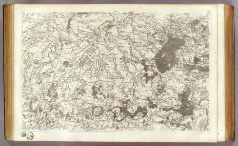
Maps of Bohain-en-Vermandois
42 Cambrai.
1 : 86400 Cassini family; Cassini, Cesar-Francois, 1714-1784
Defence of Hindenburg line no.1
1 : 20000 First World War map of defence of Hindenburg line. German artillery positions. From captured German maps dated 10-2-17. Sheet titled Joncourt. Parts of 62c NE and 62b NW. War Office
Zusammendruck Hermann-Nord
1 : 25000 Pikardie (Francie) Vermessungs-Abteilung 26
Enemy organisation 6-9-17. Nauroy 2nd ed.
1 : 20000 First World War map. Enemy organisation 6-9-17. Nauroy 2nd ed. Special sheet. War Office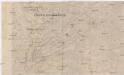
Hermann-Stellung
Francie severní Gendarmerie-Korps-Kommando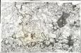
[Cambray]
1 Blatt : 60 x 91 cm Seguin; Desbruslins s.n.
Nervii. Diocese de l'Archevesché De Cambray
1 : 240000 Mollova mapová sbírka Sanson, Nicolas Sanson, Nicolas II
Ravensteins Kriegskarte Nr. 42 für das Gebiet zwischen Charleroi - Maubeuge ...

Nervii
1 Karte : Kupferdruck ; 40 x 53 cm Sanson; Robert de Vaugondy chés le Sr. Robert g. o. du roi quai de l'horloge
Département de l'Aisne
1 Karte : Kupferdruck ; 55 x 40 cm Houdan au bureau de l'atlas national rue de la Harpe no. 26 et au dépôt de cet atlas placé au cabinet bibliographique rue de la Monnoye no. 5
Dept. De L'Aisne.
1 : 512000 Levasseur, Victor.
L'Archevesche de Cambray [Karte], in: Gerardi Mercatoris et I. Hondii Newer Atlas, oder, Grosses Weltbuch, Bd. 2, S. 26.
1 Karte aus Atlas Mercator, Gerhard und Hondius, Jodocus Jansson, Jan
Archiepiscopatus Cameracensis. Archebesché de Cambray. [Karte], in: Novus Atlas, das ist, Weltbeschreibung, Bd. 2, S. 26.
1 Karte aus Atlas Blaeu, Joan Blaeu, Willem Janszoon

[20], uit: Hydro-Oro und Chorographische General Karte des Koenigreichs der Niederlande und der angrenzenden Länder bis Paris : mit der Angabe der Kunst und Heer-Strassen und der Entfernung der Poststationen / ... zusammengetragen und reducirt von ... Wilhelm Müller
1 : 400000 titelvariant: Generalkarte des Koenigreichs Hannover; Annotatie: 1e supplement bij: Generalkarte des Koenigreichs Hannover (1818) Müller, Wilhelm (fl. 1818) [Hannover : Wilhelm Müller]
Le Comté De Haynaut, Divisé En Chatellenies, Balliages, Prevostés, &c. [Karte], in: Atlas nouveau, contenant toutes les parties du monde [...], Bd. 2, S. 64.
1 Karte aus Atlas Sanson, Nicolas Jaillot, Alexis Hubert und Mortier, Pieter
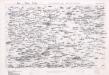
Map of water supply: St Quentin and part of Amiens
1 : 100000 Series of maps on water supplies. St Quentin and part of Amiens. War Office
Archiepiscopatus Cameracensis. Archevesché de Cambray. [Karte], in: Theatrum orbis terrarum, sive, Atlas novus, Bd. 2, S. 41.
1 Karte aus Atlas Blaeu, Joan Blaeu, Willem Janszoon
Archiepiscopatus Cameracensis. Archevesché de Cambray. [Karte], in: Le théâtre du monde, ou, Nouvel atlas contenant les chartes et descriptions de tous les païs de la terre, Bd. 2, S. 26.
1 Karte aus Atlas Blaeu, Willem Janszoon und Blaeu, Joan Blaeu, Willem Janszoon
Carte du département du Nord ou les provinces de Flandre du Hainaut et du Cambresis, 2
1 Blatt : 47 x 59 cm s.n.
Accurata delineat. comitatus Hanoniae Belgii austriaci provinc. in dition. et praefect. suas singulari studio distincti
1 : 210000 quam aeri incidit et excud. Matthaeus Seutter S. C. M. geogr. Aug. Vind. Aug[ustae] Vind[elicorum] : Matthaeus Seutter
Correctissima descriptio Hannoniae comitatus in quo castellaniarum balliviatuum praefecturarum ac territoriorum distincta divisio nec non urbium munitarum vera ostenditur delineatio
1 : 200000 per F. de Witt Amstelodami Amstelodami : per F. de Witt
Comitatus Hannoniae Tabula
1 : 208000 Mollova mapová sbírka Penez, Alexander Schenk, Peter II
Comitatus Hannoniae in suas quasque Castellanias Balliviatus praefecturas et territoria accurate divisi descriptio
1 : 435000 Belgie Homann, Johann Baptist exhibita a Ioh. Bapt. Homanno
Comitatus Hannoniae in suas quasque castellanias balliviatvs praefecturas et territoria accurate divisi descriptio
1 : 440000 Belgie Homann, Johann Baptist a Ioh. Bapt. Homanno
Veromandvorvm comitatvs
1 Karte : Kupferdruck ; 14 x 18 cm Lambert Andreae
Valenciennes 96, uit: Special-Karte von Mittel-Europa / nach amtlichen Quellen bearbeitet von W. Liebenow
1 : 300000 titelvariant: W. Liebenow's Mittel-Europa; Annotatie: Titel boven de bladen: W. Liebenow's Mittel-Europa Johannes Wilhelm Liebenow 1822-1897 Frankfurt a. M. : Ludwig Ravenstein
Le Comté de Haynaut, Diviséen Chatellenies, Balliages, Prevostés, &c.
Mollova mapová sbírka Jaillot, Alexis-Hubert Jaillot, Alexis Hubert