Maps of Aisne

Département de l'Aisne
1 Karte : Kupferdruck ; 55 x 40 cm Houdan au bureau de l'atlas national rue de la Harpe no. 26 et au dépôt de cet atlas placé au cabinet bibliographique rue de la Monnoye no. 5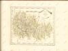

Département de l'Aisne
1 Karte : Kupferdruck ; 55 x 40 cm Houdan au bureau de l'atlas national rue de la Harpe no. 26 et au dépôt de cet atlas placé au cabinet bibliographique rue de la Monnoye no. 5
Carte géologique du département de l'Aisne
1 : 160000 Alsasko (Francie) Archiac, d' d'Archiac
Dept. De L'Aisne.
1 : 512000 Levasseur, Victor.
Département de l'Aisne
1 Karte : Kupferdruck ; 42 x 35 cm Capitaine s.n.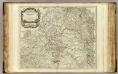
Champagne partie septentrionale.
1 : 315000 Robert de Vaugondy, Gilles, 1688-1766
Suessones populi belgicæ secundæ
1 Karte : Kupferdruck ; 40 x 47 cm Sanson; Robert de Vaugondy chés le Sr. Robert geographe ord. du roi quai de l'Horloge du Palais
[23], uit: Hydro-Oro und Chorographische General Karte des Koenigreichs der Niederlande und der angrenzenden Länder bis Paris : mit der Angabe der Kunst und Heer-Strassen und der Entfernung der Poststationen / ... zusammengetragen und reducirt von ... Wilhelm Müller
1 : 400000 titelvariant: Generalkarte des Koenigreichs Hannover; Annotatie: 1e supplement bij: Generalkarte des Koenigreichs Hannover (1818) Müller, Wilhelm (fl. 1818) [Hannover : Wilhelm Müller]
Map illustrating described itinerary in Aisne-Marne region
1 : 200000 Shows troop movements in the Aisne and Marne River areas including roads and towns from July 18th to October 12th."7426." United States. Army. Engineer Reproduction Plant. Washington, D.C. : Engineer Reproduction Plant, U.S. Army.
Evesché de Laon
1 Karte : Kupferdruck ; 40 x 45 cm Sanson; Robert de Vaugondy chés le Sr. Robert geog. ordinaire du roi quai de l'horloge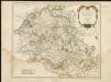
Suessones : Evesche de Soissons : où sont les Balliages et eslections de Soissons, Chasteau Thierry, et Crespy en Valois &c.
1 : 222000
Map of water supply: St Quentin
1 : 100000 Series of maps on water supplies. St Quentin. War Office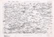
Map of water supply: St Quentin and part of Amiens
1 : 100000 Series of maps on water supplies. St Quentin and part of Amiens. War Office
Reims 110, uit: [W. Liebenow's Special-Karte von Mittel-Europa]
1 : 300000 titelvariant: W. Liebenow's Mittel-Europa; Annotatie: Titel boven de bladen: W. Liebenow's Mittel-Europa Johannes Wilhelm Liebenow 1822-1897 Hannover : Hermann Oppermann
Reims 110, uit: Special-Karte von Mittel-Europa / nach amtlichen Quellen bearbeitet von W. Liebenow
1 : 300000 titelvariant: W. Liebenow's Mittel-Europa; Annotatie: Titel boven de bladen: W. Liebenow's Mittel-Europa Johannes Wilhelm Liebenow 1822-1897 Frankfurt a. M. : Ludwig Ravenstein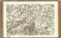
43 Laon, Noyon.
1 : 86400 Cassini family; Cassini, Cesar-Francois, 1714-1784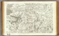
44 Soissons.
1 : 86400 Cassini family; Cassini, Cesar-Francois, 1714-1784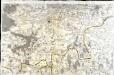
[Soissons]
1 Blatt : 60 x 91 cm s.n.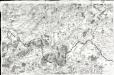
[Laon - Noyon]
1 Blatt : 60 x 91 cm s.n.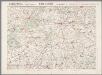
L'Aisne et la Marne, uit: Le conflict mondial : front occidental
1 : 170000 Annotatie: Ontbreekt: no. 1 en 5-8 Gand : Th. de Graeve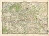
Soissons

Descriptio Veromandvorvm
2 Karten auf 1 Blatt : Kupferdruck ; je 38 x 25 cm Janssonius; Surhon; Surhon; Petit Joannes Janssonius
Descriptio Veromandvorvm
2 Karten auf 1 Blatt : Kupferdruck ; je 38 x 25 cm Valck; Schenk; Surhon; Surhon; Petit apud G. Valk et P. Schenk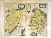
Descriptio Veromandvorvm
2 Karten auf 1 Blatt : Kupferdruck ; je 38 x 25 cm Blaeu; Blaeu; Surhon; Surhon; Petit apud Guiljelmum et Joannem Blaeuw
Veromandvorvm eorvm qve confinivm exactissima descriptio
1 Karte : Kupferdruck ; 34 x 21 cm Ortelius; Surhon; Surhon s.n.
Veromandvorvm eorvm qve confinivm exactissima descriptio
1 Karte : Kupferdruck ; 34 x 21 cm Ortelius; Surhon; Surhon s.n.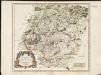
Evesché de Laon, ou sont les Duché, et Pairrie de Laon, Balliages de Laon, et Ribemont, Eslections de Laon, et de Guise etc.
1 : 211000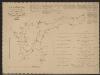
Vermandois [Karte], in: Gerardi Mercatoris et I. Hondii Newer Atlas, oder, Grosses Weltbuch, Bd. 2, S. 32.
1 Karte aus Atlas Mercator, Gerhard und Hondius, Jodocus Jansson, Jan


