Maps of Sangatte

21 Ambleteuse.
1 : 86400 Cassini family; Cassini, Cesar-Francois, 1714-1784
[Ambleteuse - Calais - Pas-de-Calais]
1 Blatt : 60 x 47 cm Brunet s.n.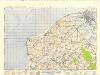
France and Belgium 1:50,000, Calais
This topographic sheet, France and Belgium 1:50 000, Series GSGS 4040 [Defences], contains standard topographic informaation including contours. Great Britain. Army. Royal Engineers. Map Reproduction Section, 18th. [S.l.] : [s.n.]
Dover A (Outline) - OS One-Inch Revised New Series
1 : 63360 Topographic maps Ordnance Survey Ordnance Survey
Dover A (Hills) - OS One-Inch Revised New Series
1 : 63360 Topographic maps Ordnance Survey Ordnance Survey
TR34 & Parts of TR33 - OS 1:25,000 Provisional Series Map
1 : 25000 Topographic maps Ordnance Survey Ordnance Survey
Calais : ville forte en Picardie ...
1 : 15000 Annotatie geografische gegevens: Zuid boven [S.l. : s.n.]
Les costes du Boulenois et le Pas de Calais
1 : 110000 Anglie jižní Fricx, Eugene Henry Harrewyn, Jacques chez Eugene Henry Fricx
Carte Particuliere d'une Partie d'Angleterre
1 : 250000 Mollova mapová sbírka Seutter, Matthäus Lotter, Tobias Conrad Seutter, Matthäus
Carte Particulière d'une partie d'Angleterre
1 : 116600 Mollova mapová sbírka Fricx, Eugène Henry Deur, Abraham Janszoon Covens, Johannes I
Les Costes du Boulenois et le Pas de Calais
1 : 116600 Mollova mapová sbírka Fricx, Eugène Henry Harrewyn, Jacques Fricx, Eugené Henry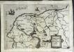
Caletense terr
1 Karte : Kupferdruck ; 14 x 21 cm Lambert Andreae
2. Carte Particuliere Partie d'Angleterre
1 : 250000 Mollova mapová sbírka Seutter, Matthäus Seutter, Matthäus
LE GOUVERNEMENT | DE CALAIS | & PAYS RECONQUIS.
[Amsterdam : Joan Blaeu]
Kent LXXVI.2 - 25 Inch Map
1 : 2500 Topographic maps Ordnance Survey Ordnance Survey
Kent LXXVI.2 - 25 Inch Map
1 : 2500 Topographic maps Ordnance Survey Ordnance Survey
Kent LXXVI.2 - 25 Inch Map
1 : 2500 Topographic maps Ordnance Survey Ordnance Survey
Kent LXXVI.1 & 2 (includes: Dover) - 25 Inch Map
1 : 2500 Topographic maps Ordnance Survey Ordnance Survey
The platt of the Lowe Countrye att Calleys
This is a map of Calais, Franceand the surrounding area from the sea. It was drawn in October 1545 by Thomas Petit. Although not formally appointed as Surveyor of the works at Calais until February 1546 Petit was in the post by October 1545 after his predecessor John Burgate died, probably of plague. The map shows the environs of Calais, recording waterways and fortifications of the area. The town of Calais is shown with the castle to the right. The Rysebank tower with its distinctive triangular bastion is also depicted. The enlargement of the fort at Rysebank was one of the main areas of work during the building programme of the 1540’s. Newneham bridge is also shown. This controlled the causeway across the marches to the west of Calais and its sluice gates could be used to dam the Hammes River and flood the low country around the town .It was therefore a vital part of the defences. Petit, Thomas
Comitatuum Boloniae et Guines Descriptio. [Karte], in: Novus Atlas, das ist, Weltbeschreibung, Bd. 2, S. 23.
1 Karte aus Atlas Blaeu, Joan Blaeu, Willem Janszoon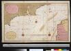
Een gedeelte van het Kanaal van de Hoofden tot den hoek van Bevesier als meede een gedeelte van de cust van Vrankrijk
English Channel Gerard van Keulen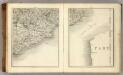
Sheets 17-18. (Cary's England, Wales, and Scotland).
1 : 360000 Cary, John, ca. 1754-1835
Caletensium Et Bononiensium Ditionis Accurata Delineatio. [Karte], in: Theatrum orbis terrarum, S. 136.
1 Karte aus Atlas Ortelius, Abraham Vrients, Jan Baptista
Oromansaci, et Gesoriacus pagus in Morinis
1 Karte : Kupferdruck ; 41 x 54 cm Sanson; Robert de Vaugondy; Cordier ches le Sr. Robert g. du r. quai de l'Horloge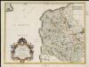
Oromansaci, et Gesoriacus Pagus in Morinis, evesché de Boulogne ou sont les Comté et seneschaussée de Boulenois : Balliage de Calais dans le Pays Reconquis : Souveraineté d'Ardres, etc.
1 : 211000
Der Kanal
1 : 150000 Dover (Anglie) Reichs-Marine-Amt
[Paskaert vande Zeeuse Vlaemse en Engelse Kusten [...]] [nordwestlicher Küstenabschnitt mit Teil der südöstlichen englischen Küste] [Karte], in: De Nieuwe Groote Vermeerderde Zee-Atlas ofte Water-Werelt, S. 37.
1 Karte aus Atlas Doncker, Hendrick
Comitatuum Boloniae et Guines Descriptio. [Karte], in: Theatrum orbis terrarum, sive, Atlas novus, Bd. 2, S. 38.
1 Karte aus Atlas Blaeu, Joan Blaeu, Willem Janszoon
Comitatuum Boloniae et Guines Descriptio. [Karte], in: Le théâtre du monde, ou, Nouvel atlas contenant les chartes et descriptions de tous les païs de la terre, Bd. 2, S. 23.
1 Karte aus Atlas Blaeu, Willem Janszoon und Blaeu, Joan Blaeu, Willem Janszoon


