Maps of Calais
Caletense terr
1 Karte : Kupferdruck ; 14 x 21 cm Lambert Andreae
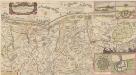
LE GOUVERNEMENT | DE CALAIS | & PAYS RECONQUIS.
[Amsterdam : Joan Blaeu]
Le Gouvernement De Calais & Pais Reconquis. [Karte], in: Novus atlas absolutissimus, Bd. 4, S. 53.
1 Karte aus Atlas Janssonius Offizin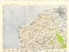
France and Belgium 1:50,000, Calais
This topographic sheet, France and Belgium 1:50 000, Series GSGS 4040 [Defences], contains standard topographic informaation including contours. Great Britain. Army. Royal Engineers. Map Reproduction Section, 18th. [S.l.] : [s.n.]
The platt of the Lowe Countrye att Calleys
This is a map of Calais, Franceand the surrounding area from the sea. It was drawn in October 1545 by Thomas Petit. Although not formally appointed as Surveyor of the works at Calais until February 1546 Petit was in the post by October 1545 after his predecessor John Burgate died, probably of plague. The map shows the environs of Calais, recording waterways and fortifications of the area. The town of Calais is shown with the castle to the right. The Rysebank tower with its distinctive triangular bastion is also depicted. The enlargement of the fort at Rysebank was one of the main areas of work during the building programme of the 1540’s. Newneham bridge is also shown. This controlled the causeway across the marches to the west of Calais and its sluice gates could be used to dam the Hammes River and flood the low country around the town .It was therefore a vital part of the defences. Petit, Thomas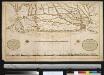
De kust van Vlaanderen van Grevelingen tot Calais int groot
France Gerard van Keulen
SIEGE DE GRAVELINES
Faict par le Sr. de Langres Ingenieur des armes de sa Majesté [Amsterdam : Joan Blaeu]
Carte du gouuernement des forts de Rebus et d'Hennuin
1 Plan : Kupferdruck ; 11 x 15 cm s.n.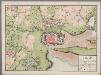
Calais : ville forte en Picardie ...
1 : 15000 Annotatie geografische gegevens: Zuid boven [S.l. : s.n.]
GRAVELINGA | Gallis | GRAVELINES | Dicta
[Amsterdam : Joan Blaeu]
Pianta della piazza di Bovrbvrg
1 : 20000 Bourbourg (Francie) Seutter, Matthäus Müller, Franz
BROVCBVRGVS vulgo BROVCBVRCH : [plan and view]
[Amsterdam : Joan Blaeu]
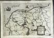
Caletensivm et Bononiensivm ditionis accvrata delineatio
1 Karte : Kupferdruck ; 34 x 24 cm Ortelius; Nicolay s.n.
Caletensivm et Bononiensivm ditionis accvrata delineatio
1 Karte : Kupferdruck ; 34 x 24 cm Ortelius; Nicolay s.n.
Bolonia [et] Gvines comitatus
1 Karte : Kupferdruck ; 31 x 24 cm Mercator; Hondius Henricus Hondius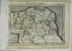
Bolonia [et] Gvines comitatus
1 Karte : Kupferdruck ; 17 x 24 cm Mercator; Keere Cloppenburgh
Bolonia [et] Gvines comitatus
1 Karte : Kupferdruck ; 31 x 23 cm Mercator; Hondius Jodocus Hondius
Bolonia [et] Gvines comitatus
1 Karte : Kupferdruck ; 31 x 24 cm Mercator s.n.

Comitatvvm Boloniæ et Gvines descriptio
1 Karte : Kupferdruck ; 37 x 48 cm Blaeu Guilielmus Blaeu excud
Bolonia [et] Gvines comitatus
1 Karte : Kupferdruck ; 36 x 48 cm Hondius; Hondius Judocus Hondius excudit
Carte des Pais Bas :
1 : 200000 Mollova mapová sbírka Le Rouge, Georges-Louis Le Rouge, Georges-Louis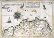
Capitainerie garde-coste d'Estaples et partie de celle de Sangatte et du Crotoy
1 Karte : 22 x 33 cm de Fer
Carte Partic. des environs de Dunkerque, Bergues, Furnes, Gravelines, Calais, et Autres
1 : 250000 Mollova mapová sbírka Seutter, Matthäus Seutter, Matthäus
Carte particuliere des environs de Dunkerque, Bergues, Furnes, Gravelines, Calais, et autres
1 Karte : Kupferdruck ; 40 x 55 cm Fricx; Harrewijn chez Eugene Henry Fricx ruë de la Madelen
Carte Particuliere des environs de Dunkerque, Bergues, Furnes, Gravelines, Calais, et Autres
1 : 116600 Mollova mapová sbírka Fricx, Eugène Henry Harrewyn, Jacques Fricx, Eugené Henry
Carte particuliere des environs de Dunkerque, Bergues, Furnes, Gravelines, Calais, et autres
1 : 110000 Belgie Fricx, Eugene Henry Harrewyn, Jacques chez Eugene Henry Fricx
Perfecte kaerte van t' Berger en Broucborger Ambacht, mitsgaders de Wateringen ende vier dycken
1 : 60000 nieulijkx verb. en uytg. door Nicolaus Visscher [Amsterdam] : nunc apud Petrum Schenk Junior
21 Ambleteuse.
1 : 86400 Cassini family; Cassini, Cesar-Francois, 1714-1784