Maps of Allegheny Plat.
A Map of the British Empire in America. (Sheet 6).
1 : 2000000 Popple, Henry
This map of Upper and Lower Canada and United States.
1 : 3700000 Tardieu, P.F.
Bowles's new one-sheet map of the independent states of Virginia, Maryland, Delaware, Pensylvania, New Jersey, New York, Connecticut, Rhode Island, &c. : comprehending also the habitations & hunting countries of the confederate Indians.
from Bowles's universal atlas. ...
Map of the Canadas.
1 : 1267200 Taylor, David
Map New York Central Lines.
1 : 4200000 New York Central Railroad Company
A New Map Of The Seat Of War.
1 : 2534400 Lewis, Samuel
A new and general map of the middle dominions belonging to the United States of America: viz. Virginia, Maryland, the Delaware-counties, Pennsylvania, New Jersey &c. with the addition of New York, & of the greatest part of New England &c as also of the bordering parts of the British possessions in Canada.
from Parts Published by Laurie & Whittle, No. 53 Fleet Street ...: London; Robert Laurie and James Whittle,
Lehigh Valley line.
1 : 4754200 Lehigh Valley Railroad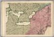
A Map of the British Empire in America. (Sheet 6).
1 : 2000000 Popple, Henry
Middle British colonies in America
from Parts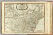
Middle dominions U.S.
1 : 2200000 Robert Laurie & James Whittle
Vereinigte Staaten von Nord-Amerika in 6 blattern, bl. 3

Nordoststaaten der Nordamerikanischen Union
1 : 3000000 New York (New York) Mielisch, H. Umbreit, E.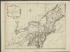
Nieuwe en nauwkeurige kaart van een gedeelte van Noord America, behelzende Nieuw England, New York, Pensylvania, New Jersey, Connecticut, Rhode Island, een stuck van Virginia, Kanda en Halifax, ter opheldering der reizen van den Heer P. Kalm
1 : 2000000 C.J. de Huyser direx. P. Mol geletterdt Te Utrecht : by de boekverkopers J. v. Schoonhoven & Comp. en G. v. d. Brink jz.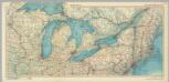
United States of America - Great Lakes. Pergamon World Atlas.
1 : 2500000 Polish Army Topography Service
Map of the Vermont Central Rail Road and its connections from Smith's map of the United States.
from Parts
Map of the northern parts of the United States of America / by Abraham Bradley.
from Parts Abraham Bradley,
A new and general map of the middle dominions belonging to the United States of America, viz. Virginia, Maryland, the Delaware-counties, Pennsylvania, New Jersey &c. with the addition of New York & of the greatest part of New England

PARTIE OCCIDENTALE de la NOUVELLE FRANCE ou du CANADA
1 : 3600000 Velká kanadská jezera (Kanada a Spojené státy americké) Bellin, Jacques-Nicolas par le Heritiers de Homan
PARTIE OCCIDENTALE de la NOUVELLE FRANCE ou du CANADA
1 : 3600000 Velká kanadská jezera (Kanada a Spojené státy americké) Bellin, Jacques-Nicolas par les Heritiers de Homan
PARTIE OCCIDENTALE de la NOUVELLE FRANCE ou du CANADA
1 : 3600000 Velká kanadská jezera (Kanada a Spojené státy americké) Bellin, Jacques-Nicolas par les Heritiers de Homan
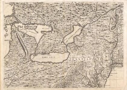
A GENERAL MAP OF THE MIDDLE BRITISH COLONIES IN AMERICA
1 : 2000000 Delaware Pownall, Thomas
United States ... North Eastern States.
1 : 2851200 Fullarton, A. & Co.
Lay's map of the United States / compiled from the latest and best authorities and actual surveys by Amos Lay, geographer and map publisher ; engraved by O.H. & D.S. Throop & Wm. Chapin.
From Whole
Carte pour servir à l'itinéraire pittoresque du fleuve Hudson et des parties latérales de l'Amerique du Nord
1 : 4200000 Milbert, Jacques Gérard Gaugain, Henri
Brooklyn V. 2, Double Page Plate No. 54 [Map bounded by Ryerson St., Myrtle Ave., Vanderbilt Ave., Flushing Ave.]
From Atlas 66. Vol. 2, 1887.
Bowles's new pocket map of the following independent states of North America: viz. Virginia, Maryland, Delaware, Pensylvania, New Jersey, New York, Connecticut & Rhode Island: comprehending also the habitations & hunting countries of the confederate Indians / by Lewis Evans.
from Charts and maps Lewis Evans,
Cours de l'Ohio, Nlle. Angleterre, Nlle. York, Pensylvanie, Virginie, Caroline.
1 : 2900000 Robert de Vaugondy, Gilles, 1688-1766
United States.
1 : 3380000 Sharpe, J.