Maps of Great Lakes
Brooklyn V. 2, Double Page Plate No. 54 [Map bounded by Ryerson St., Myrtle Ave., Vanderbilt Ave., Flushing Ave.]
From Atlas 66. Vol. 2, 1887.
Canada West (Upper).
1 : 2000000 Tanner, Henry S.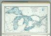
Great Lakes including Canals and Tributary Navigable Streams.
1 : 3353000 Hammond, C.S.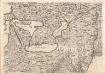
A Map of the British Empire in America. (Sheet 6).
1 : 2000000 Popple, Henry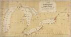
A Chart exhibiting the Light Houses, on the Lake Coasts of the United States of America
A Chart exhibiting the Light Houses, on the Lake Coasts of the United States of America.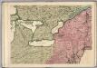
A Map of the British Empire in America. (Sheet 6).
1 : 2000000 Popple, Henry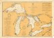
General Chart of the Northern and Northwestern Lakes
1 : 1200000 Chart showing all of the Great Lakes: Lake Superior, Lake Michigan, Lake Huron, Lake Erie, and Lake Ontario and canals, rivers and cities that border the lakes. The map also includes tables of United States and Canadian canals, annual water levels, dry docks, and marine railways. War Department, Corps of Engineers U.S. Lake Survey Office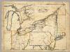
A New Map Of The Seat Of War.
1 : 2534400 Lewis, Samuel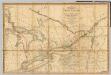
A Map of the Province of Upper Canada.
1 : 1420000 Smyth, David William
A Map of the Province of Upper Canada.
1 : 1420000 Smyth, David William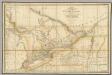
A Map of the Province of Upper Canada.
1 : 1420000 Wyld, James, 1812-1887
Ontario, Quebec.
1 : 2217600 Stanford, Edward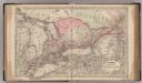
Canada West or Upper Canada.
1 : 1500000 Colton, G.W.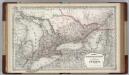
Canada. Ontario.
1 : 1500000 Colton, G.W.
Lehigh Valley line.
1 : 4754200 Lehigh Valley Railroad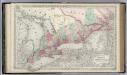
Canada West or Upper Canada.
1 : 1500000 Colton, G.W.
Dominion of Canada. Province of Ontario.
1 : 1550000 Colton, G.W.
Central Canada.
1 : 2065500 Johnston, Alexander Keith
Map Of Canada West In Counties.
1 : 2550000 Mitchell, Samuel Augustus
Canada West.
1 : 2112000 Tanner, Henry S.
Upper Canada.
1 : 2112000 Tanner, Henry S.
Haut Canada, Michigan. Amer. Sep. 42.
1 : 1641836 Vandermaelen, Philippe, 1795-1869
Canada West (Upper).
1 : 1980000 Mitchell, Samuel Augustus
Canada West (Upper).
1 : 1980000 Mitchell, Samuel Augustus
Upper Canada.
1 : 1950000 Colton, G.W.
Ontario.
1 : 2500000 Mitchell, Samuel Augustus
Ontario.
1 : 2500000 Mitchell, Samuel Augustus
Ontario.
1 : 2500000 Mitchell, Samuel Augustus Jr.
Ontario.
1 : 2600000 Mitchell, Samuel Augustus
![Brooklyn V. 2, Double Page Plate No. 54 [Map bounded by Ryerson St., Myrtle Ave., Vanderbilt Ave., Flushing Ave.]](https://images-2.georeferencer.com/images/iiif/865787875761/full/,300/0/native.jpg)

